Property Record
3515 Cincinnati Ave, Rocklin, CA 95765


Save to a Folder
{{folder.Name}}
{{folder.ListingIds.length}} Properties
{{folder.ListingIds.length}} Property
Create a New Folder
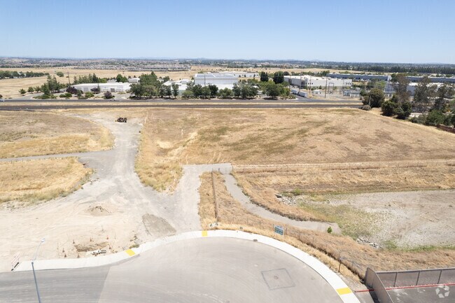
Property Detail
3515 Cincinnati Ave
Sacramento-Roseville-Folsom, CA
4.0 AC POR LOT 4 EE-37 & RES PAR 1 MBR 2022-073549
495-030-007
PLACER
Industrialacreage
California
B and X Area of moderate flood hazard, usually the area between the limits of the 100-year and 500-year floods.
4
2025
4 AC
2026
Roseville/Rocklin
021328
Sacramento
NEARBY LISTINGS FOR SALE OR LEASE
DEMOGRAPHICS near 3515 Cincinnati Ave
1 mile
3 mile
5 mile
2025 Total Population
1,699
72,542
197,306
2030 Population
1,840
76,622
208,036
Pop Growth 2025-2030
+ 8.30%
+ 5.62%
+ 5.44%
Average Age
33
38
42
2025 Total Households
447
24,048
71,994
HH Growth 2025-2030
+ 8.72%
+ 5.39%
+ 5.25%
Median Household Inc
$167,268
$129,743
$116,640
Avg Household Size
3.60
2.90
2.70
2025 Avg HH Vehicles
2.00
2.00
2.00
Median Home Value
$769,396
$733,464
$716,100
Median Year Built
2011
2005
2002
Nearby Places
Map Layers
Map Styles
 Street
 Aerial
Layers
 Traffic
 Biking
Places
Listings with unknown addresses are not visible on the map
- Restaurants
- Banks
- Shops
- Fitness
- Groceries
PUBLIC TRANSPORTATION
COMMUTER RAIL
Rocklin (Capitol Corridor - Capitol Corridor Joint Powers Authority)
Drive
Walk
Distance
Rocklin (Capitol Corridor - Capitol Corridor Joint Powers Authority)
13 min
6.0 mi
Roseville Amtrak (California Zephyr - Capitol Corridor Joint Powers Authority, Capitol Corridor - Capitol Corridor Joint Powers Authority)
Drive
Walk
Distance
Roseville Amtrak (California Zephyr - Capitol Corridor Joint Powers Authority, Capitol Corridor - Capitol Corridor Joint Powers Authority)
13 min
6.3 mi
AIRPORT
Sacramento International
Drive
Walk
Distance
Sacramento International
44 min
32.3 mi
Freight Ports
Port of Stockton
Drive
Walk
Distance
Port of Stockton
87 min
72.5 mi
SALE & LEASE HISTORY
LISTING DATE
SALE/LEASE

Oct 31, 2017
For Lease
Oct 31, 2017
For Sale
Nearby Properties
Address
Land Use
TOTAL SIZE
Lot Size
Zoning
Address
Land Use
TOTAL SIZE
Lot Size
Zoning
471,741 SF
15.14 AC
Address
Land Use
TOTAL SIZE
Lot Size
Zoning
401,656 SF
28 AC
Address
Land Use
TOTAL SIZE
Lot Size
Zoning
130,228 SF
11.10 AC
Address
Land Use
TOTAL SIZE
Lot Size
Zoning
Address
Land Use
TOTAL SIZE
Lot Size
Zoning
1,032,692 SF
81.30 AC
INPDC
Address
Land Use
TOTAL SIZE
Lot Size
Zoning
243,765 SF
14.24 AC
Address
Land Use
TOTAL SIZE
Lot Size
Zoning
144,760 SF
26.70 AC
Address
Land Use
TOTAL SIZE
Lot Size
Zoning
769,698 SF
50.39 AC
Address
Land Use
TOTAL SIZE
Lot Size
Zoning
411,344 SF
41.50 AC
Address
Land Use
TOTAL SIZE
Lot Size
Zoning
244,077 SF
8.70 AC
Address
Land Use
TOTAL SIZE
Lot Size
Zoning
162,800 SF
11.70 AC
Address
Land Use
TOTAL SIZE
Lot Size
Zoning
193,126 SF
75.84 AC
Address
Land Use
TOTAL SIZE
Lot Size
Zoning
217,756 SF
8.90 AC
Address
Land Use
TOTAL SIZE
Lot Size
Zoning
401,175 SF
19.80 AC
Address
Land Use
TOTAL SIZE
Lot Size
Zoning
191,820 SF
12.40 AC
Address
Land Use
TOTAL SIZE
Lot Size
Zoning
12,176 SF
22.70 AC
Address
Land Use
TOTAL SIZE
Lot Size
Zoning
198,530 SF
11.50 AC
Address
Land Use
TOTAL SIZE
Lot Size
Zoning
314,360 SF
18.90 AC
Address
Land Use
TOTAL SIZE
Lot Size
Zoning
222,453 SF
27.60 AC
Address
Land Use
TOTAL SIZE
Lot Size
Zoning
198,824 SF
29.66 AC
Address
Land Use
TOTAL SIZE
Lot Size
Zoning
198,824 SF
29.90 AC
Address
Land Use
TOTAL SIZE
Lot Size
Zoning
96,413 SF
7.65 AC
Address
Land Use
TOTAL SIZE
Lot Size
Zoning
118,199 SF
5.50 AC
Address
Land Use
TOTAL SIZE
Lot Size
Zoning
159,069 SF
6.09 AC
Address
Land Use
TOTAL SIZE
Lot Size
Zoning
154,420 SF
26.50 AC
Address
Land Use
TOTAL SIZE
Lot Size
Zoning
93,992 SF
6.90 AC
The World's #1 Commercial Real Estate Marketplace
Connect with us
© 2026 CoStar Group
The information above has been obtained from sources believed reliable. While we do not doubt its accuracy we have not verified it and make no guarantee, warranty or representation about it. It is your responsibility to independently confirm its accuracy and completeness. Any projections, opinions, assumptions, or estimates used are for example only and do not represent the current or future performance of the property. The value of this transaction to you depends on tax and other factors which should be evaluated by your tax, financial, and legal advisors. You and your advisors should conduct a careful, independent investigation of the property to determine to your satisfaction the suitability of the property for your needs.