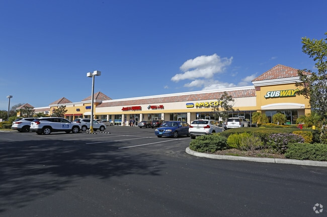
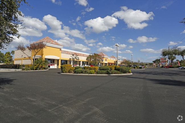
Property Record
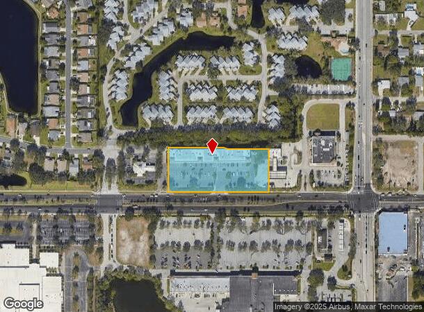
3517 53Rd Ave W, Bradenton, FL 34210
NEARBY LISTINGS FOR SALE OR LEASE
Property Detail
3517 53Rd Ave W
51885-1240-9
West Glenn Sub
Storemultistory
COM AT THE SE COR OF SEC 9, TWN 35S, RNG 17E, RUN N 00 DEG 27 MIN 39 SEC E, ALG THE E LN OF SD SEC 9, A DIST OF 34.00 FT; TH N 89 DEG 32 MIN 57 SEC W, ALG THE NLY R/W LN OF 53RD
X
Manatee
12081C0303F
Florida
2024
2.53 AC
2025
Manatee
001105
Tampa/St Petersburg
26,400 SF
North Port-Bradenton-Sarasota, FL
DEMOGRAPHICS near 3517 53Rd Ave W
1 mile
3 mile
5 mile
2024 Total Population
13,158
108,629
179,463
2029 Population
15,333
126,934
209,697
Pop Growth 2024-2029
+ 16.53%
+ 16.85%
+ 16.85%
Average Age
42
45
45
2024 Total Households
5,897
47,585
76,122
HH Growth 2024-2029
+ 15.74%
+ 16.13%
+ 16.22%
Median Household Inc
$47,622
$46,542
$51,102
Avg Household Size
2.20
2.20
2.20
2024 Avg HH Vehicles
1.00
1.00
2.00
Median Home Value
$211,615
$169,955
$221,470
Median Year Built
1982
1977
1977
Nearby Places
Map Layers
Map Styles
 Street
 Aerial
Transit
 Traffic
 Biking
Places
Listings with unknown addresses are not visible on the map
- Restaurants
- Banks
- Shops
- Fitness
- Groceries
PUBLIC TRANSPORTATION
AIRPORT
Sarasota/Bradenton International
Drive
Walk
Distance
Sarasota/Bradenton International
12 min
5.7 mi
Freight Ports
Port Manatee
Drive
Walk
Distance
Port Manatee
30 min
16.5 mi
Nearby Properties
Address
Land Use
TOTAL SIZE
Lot Size
Zoning
Address
Land Use
TOTAL SIZE
Lot Size
Zoning
623,436 SF
88.25 AC
PD-R,MP-I
Address
Land Use
TOTAL SIZE
Lot Size
Zoning
422,640 SF
12.10 AC
PD-R
Address
Land Use
TOTAL SIZE
Lot Size
Zoning
508,298 SF
18.71 AC
P
Address
Land Use
TOTAL SIZE
Lot Size
Zoning
437,460 SF
46.14 AC
PD-R
Address
Land Use
TOTAL SIZE
Lot Size
Zoning
356,808 SF
24.25 AC
RMF-9 MULT
Address
Land Use
TOTAL SIZE
Lot Size
Zoning
456,263 SF
28.02 AC
BR_R-3
Address
Land Use
TOTAL SIZE
Lot Size
Zoning
314,018 SF
28.20 AC
BR_R-3
Address
Land Use
TOTAL SIZE
Lot Size
Zoning
645,805 SF
91.21 AC
PD-PI
Address
Land Use
TOTAL SIZE
Lot Size
Zoning
279,545 SF
19.41 AC
BR_R-1
Address
Land Use
TOTAL SIZE
Lot Size
Zoning
395,543 SF
29.18 AC
BR_R-3
Address
Land Use
TOTAL SIZE
Lot Size
Zoning
507,194 SF
8.49 AC
Address
Land Use
TOTAL SIZE
Lot Size
Zoning
247,280 SF
17.72 AC
PD-R
Address
Land Use
TOTAL SIZE
Lot Size
Zoning
294,609 SF
19.15 AC
RMF9
Address
Land Use
TOTAL SIZE
Lot Size
Zoning
235,443 SF
14.75 AC
RMF-9 MULT
Address
Land Use
TOTAL SIZE
Lot Size
Zoning
117,547 SF
11.64 AC
MP-I
Address
Land Use
TOTAL SIZE
Lot Size
Zoning
153,663 SF
110.35 AC
MP-I
Address
Land Use
TOTAL SIZE
Lot Size
Zoning
214,906 SF
20.71 AC
BR_R-1
Address
Land Use
TOTAL SIZE
Lot Size
Zoning
500,923 SF
47.91 AC
Address
Land Use
TOTAL SIZE
Lot Size
Zoning
223,974 SF
17.41 AC
BR_R-2
Address
Land Use
TOTAL SIZE
Lot Size
Zoning
397,863 SF
21.60 AC
GC GENERA
Address
Land Use
TOTAL SIZE
Lot Size
Zoning
335,019 SF
32.58 AC
BR_R-3
Address
Land Use
TOTAL SIZE
Lot Size
Zoning
247,592 SF
13.39 AC
GC,RMF-6
Address
Land Use
TOTAL SIZE
Lot Size
Zoning
7,785 SF
75.25 AC
Address
Land Use
TOTAL SIZE
Lot Size
Zoning
7,772 SF
58.52 AC
RSMH-6
Address
Land Use
TOTAL SIZE
Lot Size
Zoning
198,036 SF
8.32 AC
GC GENERA
Address
Land Use
TOTAL SIZE
Lot Size
Zoning
163,868 SF
12.60 AC
BR_R-3
Address
Land Use
TOTAL SIZE
Lot Size
Zoning
162,027 SF
14.21 AC
BR_R-2
Address
Land Use
TOTAL SIZE
Lot Size
Zoning
331,144 SF
40.48 AC
PD-PI
Address
Land Use
TOTAL SIZE
Lot Size
Zoning
159,960 SF
11.30 AC
RMF-9 MULT
Address
Land Use
TOTAL SIZE
Lot Size
Zoning
583,480 SF
16.52 AC
BR_R-3
The World's #1 Commercial Real Estate Marketplace
Connect with us
© 2026 CoStar Group
The information above has been obtained from sources believed reliable. While we do not doubt its accuracy we have not verified it and make no guarantee, warranty or representation about it. It is your responsibility to independently confirm its accuracy and completeness. Any projections, opinions, assumptions, or estimates used are for example only and do not represent the current or future performance of the property. The value of this transaction to you depends on tax and other factors which should be evaluated by your tax, financial, and legal advisors. You and your advisors should conduct a careful, independent investigation of the property to determine to your satisfaction the suitability of the property for your needs.