Property Record
3517 Catclaw Dr, Abilene, TX 79606
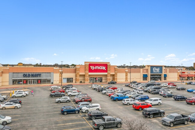

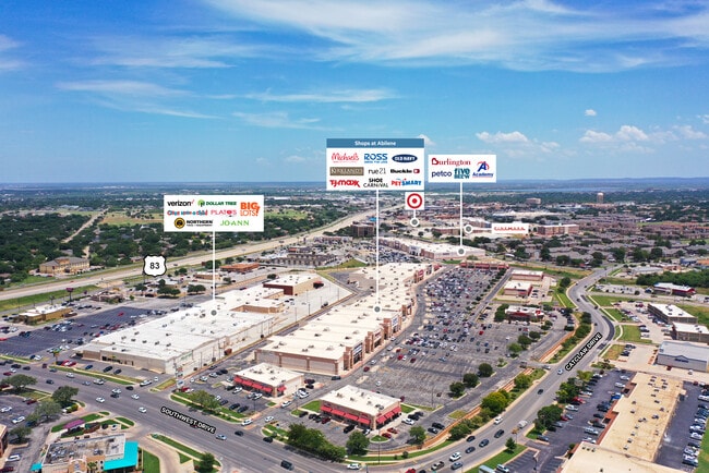
Property Detail
3517 Catclaw Dr
Abilene, TX
SHOPS AT ABILENE ADDN, BLOCK A, LOT 106 REP, ACRES 14.705
969244
TAYLOR
Multipleuses
Texas
AE The base floodplain where base flood elevations are provided. AE Zones are now used on new format FIRMs instead of A1-A30 Zones.
106
2024
14.71 AC
2025
Abilene
012802
Other Market Areas
166,901 SF
NEARBY LISTINGS FOR SALE OR LEASE
DEMOGRAPHICS near 3517 Catclaw Dr
1 mile
3 mile
5 mile
2025 Total Population
7,751
57,075
108,245
2030 Population
7,882
58,906
112,626
Pop Growth 2025-2030
+ 1.69%
+ 3.21%
+ 4.05%
Average Age
37
37
37
2025 Total Households
3,639
23,017
41,864
HH Growth 2025-2030
+ 1.84%
+ 3.27%
+ 4.19%
Median Household Inc
$61,126
$62,951
$63,419
Avg Household Size
2.10
2.40
2.40
2025 Avg HH Vehicles
1.00
2.00
2.00
Median Home Value
$226,244
$196,671
$191,932
Median Year Built
1979
1973
1974
Nearby Places
Map Layers
Map Styles
 Street
 Aerial
Transit
 Traffic
 Biking
Places
Listings with unknown addresses are not visible on the map
- Restaurants
- Banks
- Shops
- Fitness
- Groceries
PUBLIC TRANSPORTATION
AIRPORT
Abilene Regional
Drive
Walk
Distance
Abilene Regional
16 min
9.8 mi
Freight Ports
Calhoun Port
Drive
Walk
Distance
Calhoun Port
434 min
372.8 mi
SALE & LEASE HISTORY
LISTING DATE
SALE/LEASE

Mar 23, 2018
For Lease
Jun 23, 2017
For Lease
Feb 27, 2024
For Sale
Nearby Properties
Address
Land Use
TOTAL SIZE
Lot Size
Zoning
Address
Land Use
TOTAL SIZE
Lot Size
Zoning
227.42 AC
Address
Land Use
TOTAL SIZE
Lot Size
Zoning
600,001 SF
39.40 AC
Address
Land Use
TOTAL SIZE
Lot Size
Zoning
183,321 SF
11.67 AC
Address
Land Use
TOTAL SIZE
Lot Size
Zoning
234,028 SF
65.80 AC
Address
Land Use
TOTAL SIZE
Lot Size
Zoning
256,877 SF
11.04 AC
Address
Land Use
TOTAL SIZE
Lot Size
Zoning
129,462 SF
69.58 AC
Address
Land Use
TOTAL SIZE
Lot Size
Zoning
421,730 SF
30.12 AC
Address
Land Use
TOTAL SIZE
Lot Size
Zoning
117,207 SF
17.41 AC
Address
Land Use
TOTAL SIZE
Lot Size
Zoning
320,276 SF
50.74 AC
Address
Land Use
TOTAL SIZE
Lot Size
Zoning
162,480 SF
9.88 AC
Address
Land Use
TOTAL SIZE
Lot Size
Zoning
180,936 SF
31.23 AC
Address
Land Use
TOTAL SIZE
Lot Size
Zoning
143,845 SF
11.47 AC
Address
Land Use
TOTAL SIZE
Lot Size
Zoning
195,960 SF
11.07 AC
Address
Land Use
TOTAL SIZE
Lot Size
Zoning
182,328 SF
10.93 AC
Address
Land Use
TOTAL SIZE
Lot Size
Zoning
152,468 SF
18.04 AC
Address
Land Use
TOTAL SIZE
Lot Size
Zoning
159,335 SF
15.04 AC
Address
Land Use
TOTAL SIZE
Lot Size
Zoning
187,944 SF
8.69 AC
Address
Land Use
TOTAL SIZE
Lot Size
Zoning
200,648 SF
8.98 AC
Address
Land Use
TOTAL SIZE
Lot Size
Zoning
6.55 AC
Address
Land Use
TOTAL SIZE
Lot Size
Zoning
41,808 SF
3.76 AC
Address
Land Use
TOTAL SIZE
Lot Size
Zoning
195,544 SF
11 AC
Address
Land Use
TOTAL SIZE
Lot Size
Zoning
73,947 SF
9.89 AC
Address
Land Use
TOTAL SIZE
Lot Size
Zoning
71,515 SF
9.94 AC
Address
Land Use
TOTAL SIZE
Lot Size
Zoning
79,879 SF
2.86 AC
Address
Land Use
TOTAL SIZE
Lot Size
Zoning
80,574 SF
4.20 AC
Address
Land Use
TOTAL SIZE
Lot Size
Zoning
121,816 SF
3.06 AC
Address
Land Use
TOTAL SIZE
Lot Size
Zoning
146,819 SF
9.75 AC
Address
Land Use
TOTAL SIZE
Lot Size
Zoning
9.55 AC
Address
Land Use
TOTAL SIZE
Lot Size
Zoning
150,552 SF
9.72 AC
The World's #1 Commercial Real Estate Marketplace
Connect with us
© 2026 CoStar Group
The information above has been obtained from sources believed reliable. While we do not doubt its accuracy we have not verified it and make no guarantee, warranty or representation about it. It is your responsibility to independently confirm its accuracy and completeness. Any projections, opinions, assumptions, or estimates used are for example only and do not represent the current or future performance of the property. The value of this transaction to you depends on tax and other factors which should be evaluated by your tax, financial, and legal advisors. You and your advisors should conduct a careful, independent investigation of the property to determine to your satisfaction the suitability of the property for your needs.