Property Record
3519 Easter Stanley Ct, Tallahassee, FL 32308
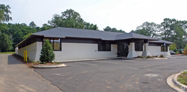


Property Detail
3519 Easter Stanley Ct
11-28-20-010-000.2
SEC 28 1N 1E OR 4967/2287 PART OF LOT 2 PER TECHNICAL AMENDMENT OR 5321/2017(TA) OR 3884/679(TA) 5303/262(TA) 5314/1951(TA)
Officebuilding
Leon
PUD
Florida
B and X Area of moderate flood hazard, usually the area between the limits of the 100-year and 500-year floods.
2
2025
0.34 AC
2025
NE Tallahassee
000907
Tallahassee
8,317 SF
Tallahassee, FL
NEARBY LISTINGS FOR SALE OR LEASE
DEMOGRAPHICS near 3519 Easter Stanley Ct
1 mile
3 mile
5 mile
2025 Total Population
8,295
57,751
148,529
2030 Population
8,517
59,021
150,646
Pop Growth 2025-2030
+ 2.68%
+ 2.20%
+ 1.43%
Average Age
40
40
37
2025 Total Households
3,913
27,182
63,387
HH Growth 2025-2030
+ 2.81%
+ 2.42%
+ 1.64%
Median Household Inc
$71,249
$72,780
$65,880
Avg Household Size
2.00
2.00
2.10
2025 Avg HH Vehicles
1.00
2.00
2.00
Median Home Value
$272,489
$328,489
$334,561
Median Year Built
1994
1986
1986
Nearby Places
Map Layers
Map Styles
 Street
 Aerial
Transit
 Traffic
 Biking
Places
Listings with unknown addresses are not visible on the map
- Restaurants
- Banks
- Shops
- Fitness
- Groceries
PUBLIC TRANSPORTATION
AIRPORT
Tallahassee International
Drive
Walk
Distance
Tallahassee International
22 min
11.3 mi
Nearby Properties
Address
Land Use
TOTAL SIZE
Lot Size
Zoning
Address
Land Use
TOTAL SIZE
Lot Size
Zoning
3,882,850 SF
22.64 AC
CM
Address
Land Use
TOTAL SIZE
Lot Size
Zoning
1,906,594 SF
112.75 AC
PUD
Address
Land Use
TOTAL SIZE
Lot Size
Zoning
361,804 SF
14.17 AC
CM
Address
Land Use
TOTAL SIZE
Lot Size
Zoning
577,345 SF
30.63 AC
Address
Land Use
TOTAL SIZE
Lot Size
Zoning
846,072 SF
166.39 AC
R1
Address
Land Use
TOTAL SIZE
Lot Size
Zoning
545,485 SF
14.01 AC
Address
Land Use
TOTAL SIZE
Lot Size
Zoning
756,294 SF
20.19 AC
OR3
Address
Land Use
TOTAL SIZE
Lot Size
Zoning
456,149 SF
22.50 AC
OR3
Address
Land Use
TOTAL SIZE
Lot Size
Zoning
775,087 SF
18.34 AC
Address
Land Use
TOTAL SIZE
Lot Size
Zoning
708,504 SF
50.44 AC
PUD
Address
Land Use
TOTAL SIZE
Lot Size
Zoning
380,000 SF
21.78 AC
PUD
Address
Land Use
TOTAL SIZE
Lot Size
Zoning
376,746 SF
12.92 AC
OR2
Address
Land Use
TOTAL SIZE
Lot Size
Zoning
473,339 SF
51.93 AC
PUD
Address
Land Use
TOTAL SIZE
Lot Size
Zoning
543,726 SF
13.13 AC
PUD
Address
Land Use
TOTAL SIZE
Lot Size
Zoning
338,790 SF
16 AC
PUD
Address
Land Use
TOTAL SIZE
Lot Size
Zoning
619,964 SF
6.47 AC
OR3
Address
Land Use
TOTAL SIZE
Lot Size
Zoning
338,619 SF
107.89 AC
GO1
Address
Land Use
TOTAL SIZE
Lot Size
Zoning
606,101 SF
19.01 AC
MR1
Address
Land Use
TOTAL SIZE
Lot Size
Zoning
312,935 SF
11.74 AC
MR1
Address
Land Use
TOTAL SIZE
Lot Size
Zoning
312,935 SF
12.82 AC
MR1
Address
Land Use
TOTAL SIZE
Lot Size
Zoning
456,212 SF
117.40 AC
MR1
Address
Land Use
TOTAL SIZE
Lot Size
Zoning
312,392 SF
14.52 AC
MR1
Address
Land Use
TOTAL SIZE
Lot Size
Zoning
534,652 SF
57.35 AC
MR1
Address
Land Use
TOTAL SIZE
Lot Size
Zoning
247,794 SF
17.24 AC
CP
Address
Land Use
TOTAL SIZE
Lot Size
Zoning
196,912 SF
17.25 AC
CP
Address
Land Use
TOTAL SIZE
Lot Size
Zoning
449,952 SF
13.18 AC
AC
Address
Land Use
TOTAL SIZE
Lot Size
Zoning
500,986 SF
19.26 AC
RP2
Address
Land Use
TOTAL SIZE
Lot Size
Zoning
131,893 SF
11.01 AC
PUD
Address
Land Use
TOTAL SIZE
Lot Size
Zoning
605,124 SF
15.72 AC
AC
Address
Land Use
TOTAL SIZE
Lot Size
Zoning
116,870 SF
7.23 AC
C2
The World's #1 Commercial Real Estate Marketplace
Connect with us
© 2026 CoStar Group
The information above has been obtained from sources believed reliable. While we do not doubt its accuracy we have not verified it and make no guarantee, warranty or representation about it. It is your responsibility to independently confirm its accuracy and completeness. Any projections, opinions, assumptions, or estimates used are for example only and do not represent the current or future performance of the property. The value of this transaction to you depends on tax and other factors which should be evaluated by your tax, financial, and legal advisors. You and your advisors should conduct a careful, independent investigation of the property to determine to your satisfaction the suitability of the property for your needs.