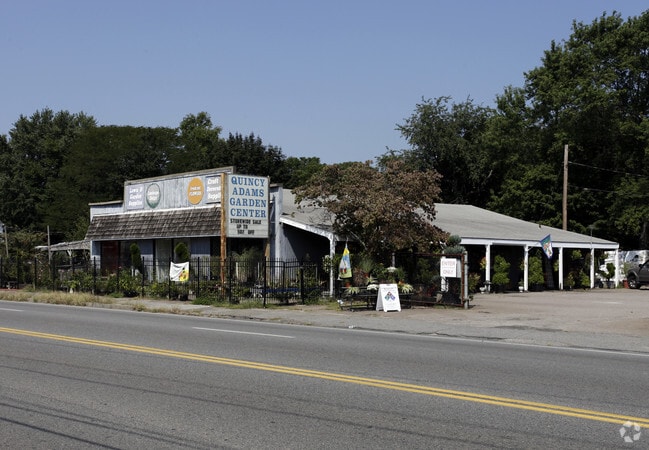
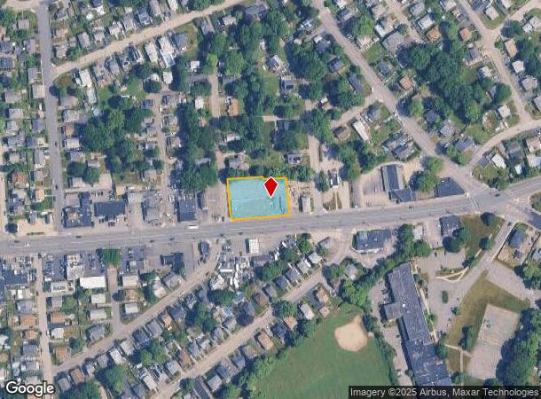
Property Record
352 Bridge St, North Weymouth, MA 02191

NEARBY LISTINGS FOR SALE OR LEASE
Property Detail
352 Bridge St
WEYM-000007-000092-000005
Norfolk
Commercialacreage
Massachusetts
X
5
25021C0227G
0.57 AC
2025
Route 3 Corridor
2025
Boston
422800
Boston-Cambridge-Newton, MA-NH
3,984 SF
DEMOGRAPHICS near 352 Bridge St
1 Mile
3 Mile
5 Mile
2024 Total Population
9,284
95,641
208,668
2029 Population
9,210
95,212
207,941
Pop Growth 2024-2029
(0.80%)
(0.45%)
(0.35%)
Average Age
43
42
42
2024 Total Households
3,776
40,982
87,101
HH Growth 2024-2029
(0.77%)
(0.40%)
(0.30%)
Median Household Inc
$91,740
$91,859
$97,878
Avg Household Size
2.40
2.30
2.30
2024 Avg HH Vehicles
2.00
2.00
2.00
Median Home Value
$454,400
$530,431
$604,127
Median Year Built
1949
1959
1958
Nearby Places
Map Layers
Map Styles
 Street
 Aerial
- Restaurants
- Banks
- Shops
- Fitness
- Groceries
PUBLIC TRANSPORTATION
COMMUTER RAIL
DRIVE
WALK
Distance
6 min
2.8 mi
West Hingham (Greenbush Line - Massachusetts Bay Transportation Authority Commuter Rail (Purple Line))
DRIVE
WALK
Distance
West Hingham (Greenbush Line - Massachusetts Bay Transportation Authority Commuter Rail (Purple Line))
7 min
3.0 mi
AIRPORT
General Edward Lawrence Logan International
DRIVE
WALK
Distance
General Edward Lawrence Logan International
26 min
14.1 mi
Freight Ports
Port of Boston
DRIVE
WALK
Distance
Port of Boston
24 min
11.9 mi
SALE & LEASE HISTORY
LISTING DATE
SALE/LEASE

Oct 02, 2019
For Sale
Nearby Properties
Address
Land Use
TOTAL SIZE
Lot Size
Zoning
Address
Land Use
TOTAL SIZE
Lot Size
Zoning
148,456 SF
0.43 AC
Address
Land Use
TOTAL SIZE
Lot Size
Zoning
3.31 AC
BUSC
Address
Land Use
TOTAL SIZE
Lot Size
Zoning
236,154 SF
1.41 AC
BUSC
Address
Land Use
TOTAL SIZE
Lot Size
Zoning
33.81 AC
A3
Address
Land Use
TOTAL SIZE
Lot Size
Zoning
9.10 AC
RESC
Address
Land Use
TOTAL SIZE
Lot Size
Zoning
202,858 SF
2.30 AC
Address
Land Use
TOTAL SIZE
Lot Size
Zoning
5.06 AC
BUSC
Address
Land Use
TOTAL SIZE
Lot Size
Zoning
233,488 SF
9.82 AC
Address
Land Use
TOTAL SIZE
Lot Size
Zoning
132,997 SF
1.45 AC
Address
Land Use
TOTAL SIZE
Lot Size
Zoning
147,611 SF
0.62 AC
BUSC
Address
Land Use
TOTAL SIZE
Lot Size
Zoning
11.90 AC
PUD
Address
Land Use
TOTAL SIZE
Lot Size
Zoning
229,928 SF
3.79 AC
Address
Land Use
TOTAL SIZE
Lot Size
Zoning
124,274 SF
0.62 AC
Address
Land Use
TOTAL SIZE
Lot Size
Zoning
233,530 SF
6.70 AC
PUD
Address
Land Use
TOTAL SIZE
Lot Size
Zoning
134,342 SF
1.03 AC
BUSC
Address
Land Use
TOTAL SIZE
Lot Size
Zoning
172,027 SF
3.73 AC
100
Address
Land Use
TOTAL SIZE
Lot Size
Zoning
617,116 SF
79.59 AC
INDB
Address
Land Use
TOTAL SIZE
Lot Size
Zoning
204,944 SF
3.83 AC
Address
Land Use
TOTAL SIZE
Lot Size
Zoning
9.94 AC
Address
Land Use
TOTAL SIZE
Lot Size
Zoning
3,375 SF
12.03 AC
PUD
Address
Land Use
TOTAL SIZE
Lot Size
Zoning
10.04 AC
PUD
Address
Land Use
TOTAL SIZE
Lot Size
Zoning
244,796 SF
2.42 AC
Address
Land Use
TOTAL SIZE
Lot Size
Zoning
11.39 AC
100
Address
Land Use
TOTAL SIZE
Lot Size
Zoning
111,871 SF
4.72 AC
RESC
Address
Land Use
TOTAL SIZE
Lot Size
Zoning
122,808 SF
3.41 AC
Address
Land Use
TOTAL SIZE
Lot Size
Zoning
1.36 AC
BUSC
Address
Land Use
TOTAL SIZE
Lot Size
Zoning
5.03 AC
Address
Land Use
TOTAL SIZE
Lot Size
Zoning
5.59 AC
PUD
Address
Land Use
TOTAL SIZE
Lot Size
Zoning
83.36 AC
BUSB
Address
Land Use
TOTAL SIZE
Lot Size
Zoning
132,194 SF
4 AC
RESC
The World's #1 Commercial Real Estate Marketplace
Connect with us
© 2025 CoStar Group
The information above has been obtained from sources believed reliable. While we do not doubt its accuracy we have not verified it and make no guarantee, warranty or representation about it. It is your responsibility to independently confirm its accuracy and completeness. Any projections, opinions, assumptions, or estimates used are for example only and do not represent the current or future performance of the property. The value of this transaction to you depends on tax and other factors which should be evaluated by your tax, financial, and legal advisors. You and your advisors should conduct a careful, independent investigation of the property to determine to your satisfaction the suitability of the property for your needs.