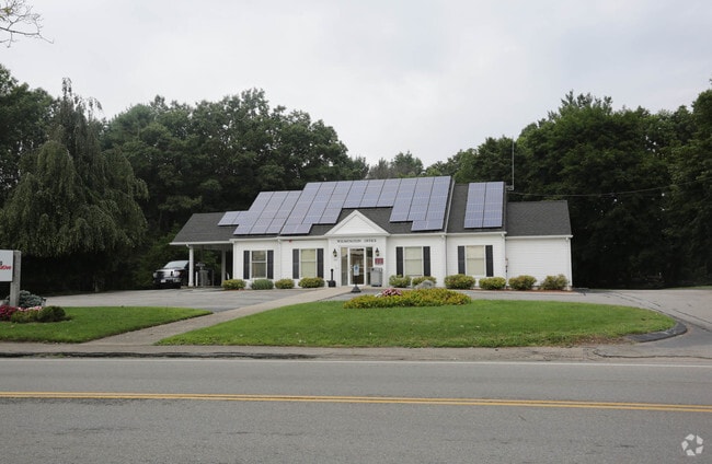
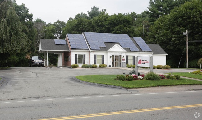
Property Record
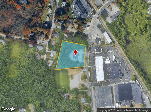
352 Middlesex Ave, Wilmington, MA 01887
NEARBY LISTINGS FOR SALE OR LEASE
Property Detail
352 Middlesex Ave
Financialbuilding
Middlesex
X
Massachusetts
25017C0283G
2.10 AC
2025
Wilmington/Reading
2025
Boston
331101
Boston-Cambridge-Newton, MA-NH
3,787 SF
WILM-000079-000000-000000-000010
DEMOGRAPHICS near 352 Middlesex Ave
1 mile
3 mile
5 mile
2024 Total Population
5,543
41,952
131,245
2029 Population
5,438
41,474
130,071
Pop Growth 2024-2029
(1.89%)
(1.14%)
(0.89%)
Average Age
42
42
42
2024 Total Households
1,945
14,924
47,515
HH Growth 2024-2029
(2.06%)
(1.23%)
(0.92%)
Median Household Inc
$154,005
$131,698
$132,296
Avg Household Size
2.80
2.70
2.70
2024 Avg HH Vehicles
2.00
2.00
2.00
Median Home Value
$634,816
$631,670
$660,051
Median Year Built
1968
1974
1972
Nearby Places
Map Layers
Map Styles
 Street
 Aerial
Transit
 Traffic
 Biking
Places
Listings with unknown addresses are not visible on the map
- Restaurants
- Banks
- Shops
- Fitness
- Groceries
PUBLIC TRANSPORTATION
COMMUTER RAIL
North Wilmington (Haverhill Line - Massachusetts Bay Transportation Authority Commuter Rail (Purple Line))
Drive
Walk
Distance
North Wilmington (Haverhill Line - Massachusetts Bay Transportation Authority Commuter Rail (Purple Line))
0 min
3 min
0.2 mi
Wilmington (Lowell Line - Massachusetts Bay Transportation Authority Commuter Rail (Purple Line))
Drive
Walk
Distance
Wilmington (Lowell Line - Massachusetts Bay Transportation Authority Commuter Rail (Purple Line))
3 min
1.8 mi
AIRPORT
General Edward Lawrence Logan International
Drive
Walk
Distance
General Edward Lawrence Logan International
28 min
19.1 mi
Manchester Boston Regional
Drive
Walk
Distance
Manchester Boston Regional
50 min
35.2 mi
Freight Ports
Port of Boston
Drive
Walk
Distance
Port of Boston
28 min
18.9 mi
Nearby Properties
Address
Land Use
TOTAL SIZE
Lot Size
Zoning
Address
Land Use
TOTAL SIZE
Lot Size
Zoning
196,098 SF
22.41 AC
R20
Address
Land Use
TOTAL SIZE
Lot Size
Zoning
502,199 SF
47.78 AC
IO
Address
Land Use
TOTAL SIZE
Lot Size
Zoning
275,751 SF
41.30 AC
R20
Address
Land Use
TOTAL SIZE
Lot Size
Zoning
272,632 SF
22.49 AC
IND
Address
Land Use
TOTAL SIZE
Lot Size
Zoning
341,215 SF
16.94 AC
IND
Address
Land Use
TOTAL SIZE
Lot Size
Zoning
591,906 SF
153.43 AC
IA
Address
Land Use
TOTAL SIZE
Lot Size
Zoning
304,672 SF
58.97 AC
HB
Address
Land Use
TOTAL SIZE
Lot Size
Zoning
368,748 SF
40.10 AC
IND
Address
Land Use
TOTAL SIZE
Lot Size
Zoning
398,140 SF
39.50 AC
GI
Address
Land Use
TOTAL SIZE
Lot Size
Zoning
141,968 SF
11.28 AC
R20
Address
Land Use
TOTAL SIZE
Lot Size
Zoning
343,105 SF
60.18 AC
IND
Address
Land Use
TOTAL SIZE
Lot Size
Zoning
264,976 SF
34.74 AC
Address
Land Use
TOTAL SIZE
Lot Size
Zoning
78,384 SF
34.20 AC
IO
Address
Land Use
TOTAL SIZE
Lot Size
Zoning
221,927 SF
27.88 AC
IND
Address
Land Use
TOTAL SIZE
Lot Size
Zoning
161,736 SF
13.91 AC
Address
Land Use
TOTAL SIZE
Lot Size
Zoning
193.30 AC
IA
Address
Land Use
TOTAL SIZE
Lot Size
Zoning
145,745 SF
11.54 AC
GI
Address
Land Use
TOTAL SIZE
Lot Size
Zoning
175,682 SF
20.80 AC
IB
Address
Land Use
TOTAL SIZE
Lot Size
Zoning
238,042 SF
28 AC
IND
Address
Land Use
TOTAL SIZE
Lot Size
Zoning
127,016 SF
11.01 AC
IB
Address
Land Use
TOTAL SIZE
Lot Size
Zoning
150,335 SF
23.33 AC
COM
Address
Land Use
TOTAL SIZE
Lot Size
Zoning
272,896 SF
28.60 AC
IND
Address
Land Use
TOTAL SIZE
Lot Size
Zoning
206,905 SF
13.31 AC
IND
Address
Land Use
TOTAL SIZE
Lot Size
Zoning
290,370 SF
21.37 AC
IND
Address
Land Use
TOTAL SIZE
Lot Size
Zoning
124,741 SF
13.35 AC
HB
Address
Land Use
TOTAL SIZE
Lot Size
Zoning
166,800 SF
13.25 AC
GI
Address
Land Use
TOTAL SIZE
Lot Size
Zoning
148,284 SF
8.16 AC
IB
Address
Land Use
TOTAL SIZE
Lot Size
Zoning
72,280 SF
4.57 AC
GI
Address
Land Use
TOTAL SIZE
Lot Size
Zoning
119,992 SF
9.60 AC
S20
Address
Land Use
TOTAL SIZE
Lot Size
Zoning
122,112 SF
15.78 AC
S20
The World's #1 Commercial Real Estate Marketplace
Connect with us
© 2026 CoStar Group
The information above has been obtained from sources believed reliable. While we do not doubt its accuracy we have not verified it and make no guarantee, warranty or representation about it. It is your responsibility to independently confirm its accuracy and completeness. Any projections, opinions, assumptions, or estimates used are for example only and do not represent the current or future performance of the property. The value of this transaction to you depends on tax and other factors which should be evaluated by your tax, financial, and legal advisors. You and your advisors should conduct a careful, independent investigation of the property to determine to your satisfaction the suitability of the property for your needs.