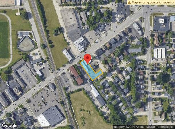
Property Record
352 N Main St, Plymouth, MI 48170

Current Lease Availabilities
NEARBY LISTINGS FOR SALE OR LEASE
Property Detail
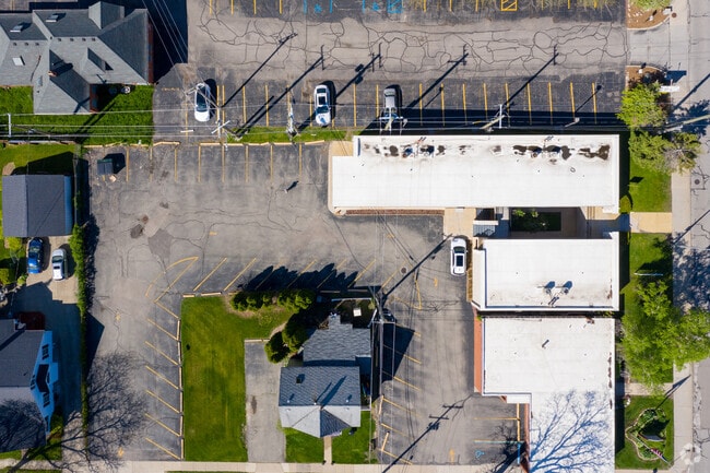
352 N Main St
Detroit-Warren-Dearborn, MI
Assessors Plymouth Plat No 14
49-005-01-0375-000
26E375 376 LOTS 375 AND 376 ASSESSORS PLYMOUTH PLAT NO 14 TIS R8E L66 P80 WCR
Officebuilding
Wayne
X
Michigan
26163C0039E
375-376
2025
0.40 AC
2025
Southern I-275 Corridor
562500
Detroit
6,600 SF
DEMOGRAPHICS near 352 N Main St
1 Mile
3 Mile
5 Mile
2024 Total Population
8,982
64,065
175,288
2029 Population
8,681
61,350
168,260
Pop Growth 2024-2029
(3.35%)
(4.24%)
(4.01%)
Average Age
43
44
43
2024 Total Households
4,426
27,172
72,841
HH Growth 2024-2029
(3.28%)
(4.13%)
(3.93%)
Median Household Inc
$90,898
$103,643
$98,216
Avg Household Size
2.00
2.30
2.40
2024 Avg HH Vehicles
2.00
2.00
2.00
Median Home Value
$359,490
$314,993
$304,984
Median Year Built
1960
1974
1977
Nearby Places
Map Layers
Map Styles
 Street
 Aerial
- Restaurants
- Banks
- Shops
- Fitness
- Groceries
PUBLIC TRANSPORTATION
AIRPORT
Detroit Metro Wayne County
DRIVE
WALK
Distance
Detroit Metro Wayne County
30 min
19.6 mi
Windsor International
DRIVE
WALK
Distance
Windsor International
53 min
34.2 mi
Freight Ports
DRIVE
WALK
Distance
75 min
60.1 mi
Nearby Properties
Address
Land Use
TOTAL SIZE
Lot Size
Zoning
Address
Land Use
TOTAL SIZE
Lot Size
Zoning
1,005,040 SF
Address
Land Use
TOTAL SIZE
Lot Size
Zoning
234,403 SF
74.21 AC
OS
Address
Land Use
TOTAL SIZE
Lot Size
Zoning
250,699 SF
16.89 AC
SH
Address
Land Use
TOTAL SIZE
Lot Size
Zoning
37.30 AC
MR
Address
Land Use
TOTAL SIZE
Lot Size
Zoning
517,265 SF
116.72 AC
Address
Land Use
TOTAL SIZE
Lot Size
Zoning
192,478 SF
IND
Address
Land Use
TOTAL SIZE
Lot Size
Zoning
408,122 SF
23.31 AC
MR
Address
Land Use
TOTAL SIZE
Lot Size
Zoning
21.71 AC
MR
Address
Land Use
TOTAL SIZE
Lot Size
Zoning
334,346 SF
55.65 AC
TAR
Address
Land Use
TOTAL SIZE
Lot Size
Zoning
114,894 SF
4.94 AC
ARC
Address
Land Use
TOTAL SIZE
Lot Size
Zoning
361,807 SF
18.77 AC
M-2
Address
Land Use
TOTAL SIZE
Lot Size
Zoning
225,164 SF
25.66 AC
IND
Address
Land Use
TOTAL SIZE
Lot Size
Zoning
283,710 SF
IND
Address
Land Use
TOTAL SIZE
Lot Size
Zoning
221,508 SF
26.03 AC
IND
Address
Land Use
TOTAL SIZE
Lot Size
Zoning
113,292 SF
15.79 AC
IND
Address
Land Use
TOTAL SIZE
Lot Size
Zoning
99,826 SF
ORT
Address
Land Use
TOTAL SIZE
Lot Size
Zoning
123,225 SF
9 AC
CJ/ARC
Address
Land Use
TOTAL SIZE
Lot Size
Zoning
954,882 SF
47.92 AC
LI-2
Address
Land Use
TOTAL SIZE
Lot Size
Zoning
46.60 AC
R-3
Address
Land Use
TOTAL SIZE
Lot Size
Zoning
78,164 SF
5.51 AC
PUD
Address
Land Use
TOTAL SIZE
Lot Size
Zoning
103,075 SF
8.15 AC
PUD
Address
Land Use
TOTAL SIZE
Lot Size
Zoning
172,094 SF
11.84 AC
M-2
Address
Land Use
TOTAL SIZE
Lot Size
Zoning
243,371 SF
16.04 AC
Address
Land Use
TOTAL SIZE
Lot Size
Zoning
135,586 SF
8.08 AC
IND
Address
Land Use
TOTAL SIZE
Lot Size
Zoning
191,759 SF
26.11 AC
ORT
Address
Land Use
TOTAL SIZE
Lot Size
Zoning
14,023 SF
17.32 AC
RM-1
Address
Land Use
TOTAL SIZE
Lot Size
Zoning
484,535 SF
30.20 AC
IND
Address
Land Use
TOTAL SIZE
Lot Size
Zoning
127,811 SF
6.95 AC
M-2
Address
Land Use
TOTAL SIZE
Lot Size
Zoning
122,116 SF
4.99 AC
PUD
Address
Land Use
TOTAL SIZE
Lot Size
Zoning
145,232 SF
7.16 AC
M-2
The World's #1 Commercial Real Estate Marketplace
Connect with us
© 2026 CoStar Group
The information above has been obtained from sources believed reliable. While we do not doubt its accuracy we have not verified it and make no guarantee, warranty or representation about it. It is your responsibility to independently confirm its accuracy and completeness. Any projections, opinions, assumptions, or estimates used are for example only and do not represent the current or future performance of the property. The value of this transaction to you depends on tax and other factors which should be evaluated by your tax, financial, and legal advisors. You and your advisors should conduct a careful, independent investigation of the property to determine to your satisfaction the suitability of the property for your needs.