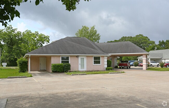
Property Record
3520 E 15Th St, Panama City, FL 32404


NEARBY LISTINGS FOR SALE OR LEASE
Property Detail
3520 E 15Th St
Panama City, FL
Springfield Farms
15088-010-000
SPRINGFIELD FARMS COM AT NW COR OF SEC TH E 270 S 20 TO NW COR OF LOT 1 BLK 3 TH CONT S 9.26 TO S R/W LINE OF HWY 98 TH E 119.99 TO POB TH CONT E 120 TO E LINE OF LOT 1 S 250 W 120 N 250 TO POB ORB 3932 P 1351
Officebuilding
Bay
X
Florida
12005C0361J
1
2023
0.69 AC
2024
Panama City
001100
Other Market Areas
3,130 SF
DEMOGRAPHICS near 3520 E 15Th St
1 Mile
3 Mile
5 Mile
2024 Total Population
4,238
32,589
69,895
2029 Population
4,552
34,963
74,513
Pop Growth 2024-2029
+ 7.41%
+ 7.28%
+ 6.61%
Average Age
37
38
39
2024 Total Households
1,517
12,013
26,820
HH Growth 2024-2029
+ 7.91%
+ 7.77%
+ 7.10%
Median Household Inc
$50,022
$48,545
$55,777
Avg Household Size
2.60
2.60
2.50
2024 Avg HH Vehicles
2.00
2.00
2.00
Median Home Value
$168,074
$147,809
$188,646
Median Year Built
1985
1983
1986
Nearby Places
Map Layers
Map Styles
 Street
 Aerial
- Restaurants
- Banks
- Shops
- Fitness
- Groceries
PUBLIC TRANSPORTATION
AIRPORT
Northwest Florida Beaches International
DRIVE
WALK
Distance
Northwest Florida Beaches International
38 min
24.7 mi
SALE & LEASE HISTORY
LISTING DATE
SALE/LEASE

Jun 15, 2017
For Lease
Jun 15, 2017
For Sale
Nearby Properties
Address
Land Use
TOTAL SIZE
Lot Size
Zoning
Address
Land Use
TOTAL SIZE
Lot Size
Zoning
764,032 SF
12.80 AC
PC14
Address
Land Use
TOTAL SIZE
Lot Size
Zoning
226,068 SF
12.80 AC
Address
Land Use
TOTAL SIZE
Lot Size
Zoning
263,872 SF
41.43 AC
PC12
Address
Land Use
TOTAL SIZE
Lot Size
Zoning
415,651 SF
266 AC
BC13
Address
Land Use
TOTAL SIZE
Lot Size
Zoning
Address
Land Use
TOTAL SIZE
Lot Size
Zoning
122,813 SF
9.58 AC
PC09
Address
Land Use
TOTAL SIZE
Lot Size
Zoning
424,813 SF
30 AC
Address
Land Use
TOTAL SIZE
Lot Size
Zoning
Address
Land Use
TOTAL SIZE
Lot Size
Zoning
115,472 SF
9.10 AC
Address
Land Use
TOTAL SIZE
Lot Size
Zoning
118,302 SF
8 AC
PC05
Address
Land Use
TOTAL SIZE
Lot Size
Zoning
126,234 SF
20.02 AC
PI
Address
Land Use
TOTAL SIZE
Lot Size
Zoning
113,514 SF
14.51 AC
UND
Address
Land Use
TOTAL SIZE
Lot Size
Zoning
101,092 SF
10.27 AC
PC09
Address
Land Use
TOTAL SIZE
Lot Size
Zoning
60,670 SF
15 AC
Address
Land Use
TOTAL SIZE
Lot Size
Zoning
46,706 SF
2.18 AC
PC09
Address
Land Use
TOTAL SIZE
Lot Size
Zoning
189,909 SF
27.77 AC
PC14
Address
Land Use
TOTAL SIZE
Lot Size
Zoning
93,125 SF
12.05 AC
PI
Address
Land Use
TOTAL SIZE
Lot Size
Zoning
56,928 SF
6.80 AC
PC09
Address
Land Use
TOTAL SIZE
Lot Size
Zoning
100,512 SF
11.84 AC
PC09
Address
Land Use
TOTAL SIZE
Lot Size
Zoning
34,664 SF
19.20 AC
PC09
Address
Land Use
TOTAL SIZE
Lot Size
Zoning
254,729 SF
24.39 AC
PC09
Address
Land Use
TOTAL SIZE
Lot Size
Zoning
46,176 SF
1.36 AC
PC09
Address
Land Use
TOTAL SIZE
Lot Size
Zoning
107,778 SF
10 AC
Address
Land Use
TOTAL SIZE
Lot Size
Zoning
67,236 SF
0.40 AC
PC14
Address
Land Use
TOTAL SIZE
Lot Size
Zoning
29,545 SF
3.17 AC
PC09
Address
Land Use
TOTAL SIZE
Lot Size
Zoning
55,325 SF
3.25 AC
PC09
Address
Land Use
TOTAL SIZE
Lot Size
Zoning
38,860 SF
4.32 AC
Address
Land Use
TOTAL SIZE
Lot Size
Zoning
54,334 SF
2.13 AC
PC09
Address
Land Use
TOTAL SIZE
Lot Size
Zoning
74,914 SF
14.23 AC
BC02
Address
Land Use
TOTAL SIZE
Lot Size
Zoning
181,571 SF
22.29 AC
CLWY04
The World's #1 Commercial Real Estate Marketplace
Connect with us
© 2025 CoStar Group
The information above has been obtained from sources believed reliable. While we do not doubt its accuracy we have not verified it and make no guarantee, warranty or representation about it. It is your responsibility to independently confirm its accuracy and completeness. Any projections, opinions, assumptions, or estimates used are for example only and do not represent the current or future performance of the property. The value of this transaction to you depends on tax and other factors which should be evaluated by your tax, financial, and legal advisors. You and your advisors should conduct a careful, independent investigation of the property to determine to your satisfaction the suitability of the property for your needs.