Property Record
3520 N Stockton Hill Rd, Kingman, AZ 86409
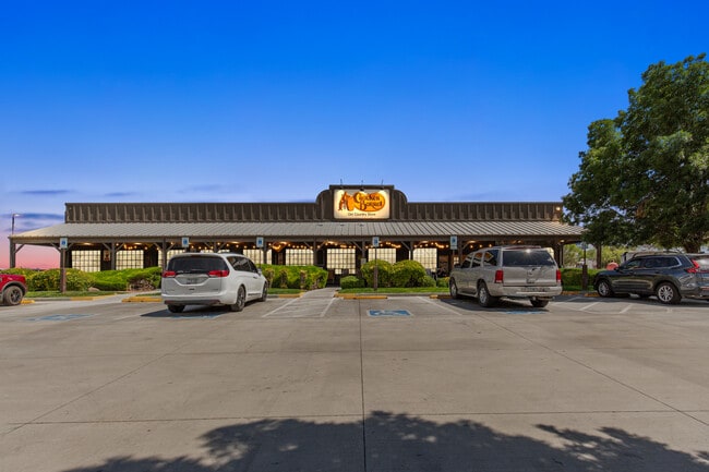
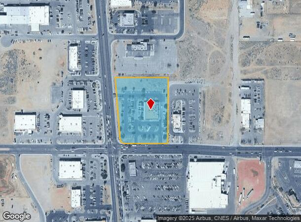
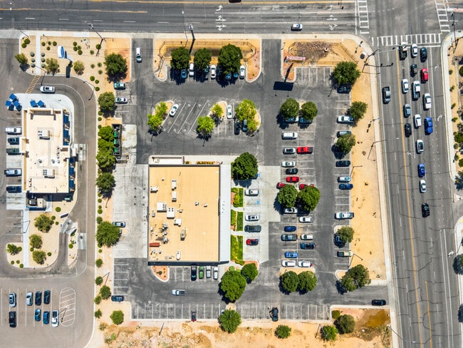
This Property Is For Sale
NEARBY LISTINGS FOR SALE OR LEASE
Property Detail
3520 N Stockton Hill Rd
Lake Havasu City-Kingman, AZ
Stockton Hill
320-03-193
THOSE PORS GOVT LOT 18 LYING ELY OF ELY R/W LN OF STOCKTON HILL RD 100.00 WIDE (DKT 139/ 286) AND N OF AIRWAY AVE DESC AS FOLL: COMM AT THE SE COR OF LOT 18; TH WLY ALONG THE S LN OF SEC 6 N89 DEG 4903 W 752.53 TO A PT ON ELY R/W STOCKTON HILL RD; TH
Restaurantbuilding
Mohave
X
Arizona
04015C4556H
18
2024
3.16 AC
2026
Prescott & Sedona
953901
Other Market Areas
9,898 SF
DEMOGRAPHICS near 3520 N Stockton Hill Rd
1 Mile
3 Mile
5 Mile
2024 Total Population
7,194
34,829
49,993
2029 Population
7,768
37,578
54,282
Pop Growth 2024-2029
+ 7.98%
+ 7.89%
+ 8.58%
Average Age
45
44
44
2024 Total Households
3,091
14,152
20,393
HH Growth 2024-2029
+ 8.77%
+ 8.64%
+ 9.36%
Median Household Inc
$46,028
$43,253
$45,762
Avg Household Size
2.20
2.40
2.40
2024 Avg HH Vehicles
2.00
2.00
2.00
Median Home Value
$185,524
$168,025
$181,889
Median Year Built
1993
1989
1992
Nearby Places
- Restaurants
- Banks
- Shops
- Fitness
- Groceries
PUBLIC TRANSPORTATION
COMMUTER RAIL
Kingman (Southwest Chief - Amtrak)
DRIVE
WALK
Distance
Kingman (Southwest Chief - Amtrak)
6 min
3.7 mi
AIRPORT
Laughlin/Bullhead International
DRIVE
WALK
Distance
Laughlin/Bullhead International
52 min
37.2 mi
Freight Ports
Port of San Diego
DRIVE
WALK
Distance
Port of San Diego
415 min
364.5 mi
Nearby Properties
Address
Land Use
TOTAL SIZE
Lot Size
Zoning
Address
Land Use
TOTAL SIZE
Lot Size
Zoning
1,005,590 SF
26.14 AC
Address
Land Use
TOTAL SIZE
Lot Size
Zoning
180,008 SF
16.14 AC
Address
Land Use
TOTAL SIZE
Lot Size
Zoning
225,678 SF
60.23 AC
Address
Land Use
TOTAL SIZE
Lot Size
Zoning
644,364 SF
21.56 AC
Address
Land Use
TOTAL SIZE
Lot Size
Zoning
94,623 SF
4.79 AC
Address
Land Use
TOTAL SIZE
Lot Size
Zoning
141,529 SF
33.48 AC
Address
Land Use
TOTAL SIZE
Lot Size
Zoning
117,905 SF
9.83 AC
Address
Land Use
TOTAL SIZE
Lot Size
Zoning
55,166 SF
2.34 AC
Address
Land Use
TOTAL SIZE
Lot Size
Zoning
124,168 SF
8.70 AC
Address
Land Use
TOTAL SIZE
Lot Size
Zoning
34,658 SF
10.73 AC
Address
Land Use
TOTAL SIZE
Lot Size
Zoning
79,417 SF
19.64 AC
Address
Land Use
TOTAL SIZE
Lot Size
Zoning
48,720 SF
2.24 AC
Address
Land Use
TOTAL SIZE
Lot Size
Zoning
59,688 SF
2.24 AC
Address
Land Use
TOTAL SIZE
Lot Size
Zoning
40,837 SF
4.55 AC
Address
Land Use
TOTAL SIZE
Lot Size
Zoning
97,756 SF
9.98 AC
Address
Land Use
TOTAL SIZE
Lot Size
Zoning
60,000 SF
3.90 AC
Address
Land Use
TOTAL SIZE
Lot Size
Zoning
41,167 SF
8.42 AC
Address
Land Use
TOTAL SIZE
Lot Size
Zoning
80,602 SF
6.57 AC
Address
Land Use
TOTAL SIZE
Lot Size
Zoning
65,458 SF
1.82 AC
Address
Land Use
TOTAL SIZE
Lot Size
Zoning
104,032 SF
11.47 AC
Address
Land Use
TOTAL SIZE
Lot Size
Zoning
44,253 SF
4.76 AC
Address
Land Use
TOTAL SIZE
Lot Size
Zoning
22,994 SF
9.76 AC
Address
Land Use
TOTAL SIZE
Lot Size
Zoning
109,899 SF
10.83 AC
Address
Land Use
TOTAL SIZE
Lot Size
Zoning
36,554 SF
3.45 AC
Address
Land Use
TOTAL SIZE
Lot Size
Zoning
46,449 SF
1.47 AC
Address
Land Use
TOTAL SIZE
Lot Size
Zoning
69,452 SF
6.63 AC
Address
Land Use
TOTAL SIZE
Lot Size
Zoning
34,109 SF
3.73 AC
Address
Land Use
TOTAL SIZE
Lot Size
Zoning
31,550 SF
6.06 AC
Address
Land Use
TOTAL SIZE
Lot Size
Zoning
53,642 SF
1.48 AC
Address
Land Use
TOTAL SIZE
Lot Size
Zoning
49,436 SF
4.35 AC
The World's #1 Commercial Real Estate Marketplace
Connect with us
© 2025 CoStar Group
The information above has been obtained from sources believed reliable. While we do not doubt its accuracy we have not verified it and make no guarantee, warranty or representation about it. It is your responsibility to independently confirm its accuracy and completeness. Any projections, opinions, assumptions, or estimates used are for example only and do not represent the current or future performance of the property. The value of this transaction to you depends on tax and other factors which should be evaluated by your tax, financial, and legal advisors. You and your advisors should conduct a careful, independent investigation of the property to determine to your satisfaction the suitability of the property for your needs.