Property Record
3522 Sam Rayburn Hwy, Melissa, TX 75454
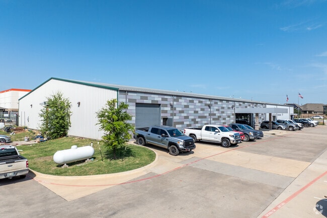
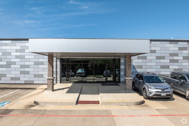
Property Detail
3522 Sam Rayburn Hwy
Dallas-Fort Worth-Arlington, TX
MELISSA INDUSTRIAL PARK, LOT 1B; * REPLAT *
R-4656-000-001A-1
COLLIN
Industrialgeneral
Texas
B and X Area of moderate flood hazard, usually the area between the limits of the 100-year and 500-year floods.
1b
2025
1.73 AC
2025
Outlying Collin Cnty
030201
Dallas/Ft Worth
20,000 SF
NEARBY LISTINGS FOR SALE OR LEASE
-
-
View all Melissa listings for sale on LoopNet.com
DEMOGRAPHICS near 3522 Sam Rayburn Hwy
1 mile
3 mile
5 mile
2025 Total Population
7,014
30,901
59,525
2030 Population
8,329
36,702
70,767
Pop Growth 2025-2030
+ 18.75%
+ 18.77%
+ 18.89%
Average Age
35
36
36
2025 Total Households
2,133
9,742
19,142
HH Growth 2025-2030
+ 18.99%
+ 19.06%
+ 19.18%
Median Household Inc
$131,199
$130,792
$124,697
Avg Household Size
3.30
3.20
3.10
2025 Avg HH Vehicles
2.00
2.00
2.00
Median Home Value
$560,126
$497,168
$474,256
Median Year Built
2011
2011
2011
Nearby Places
Map Layers
Map Styles
 Street
 Aerial
Transit
 Traffic
 Biking
Places
Listings with unknown addresses are not visible on the map
- Restaurants
- Banks
- Shops
- Fitness
- Groceries
PUBLIC TRANSPORTATION
AIRPORT
Dallas Love Field
Drive
Walk
Distance
Dallas Love Field
53 min
43.0 mi
Dallas-Fort Worth International
Drive
Walk
Distance
Dallas-Fort Worth International
52 min
45.3 mi
SALE & LEASE HISTORY
LISTING DATE
SALE/LEASE

Jun 14, 2017
For Sale
Nearby Properties
Address
Land Use
TOTAL SIZE
Lot Size
Zoning
Address
Land Use
TOTAL SIZE
Lot Size
Zoning
244,746 SF
34.90 AC
Address
Land Use
TOTAL SIZE
Lot Size
Zoning
334,535 SF
75.25 AC
Address
Land Use
TOTAL SIZE
Lot Size
Zoning
226,096 SF
51.58 AC
Address
Land Use
TOTAL SIZE
Lot Size
Zoning
298,586 SF
13.37 AC
PD
Address
Land Use
TOTAL SIZE
Lot Size
Zoning
322,580 SF
12.40 AC
Address
Land Use
TOTAL SIZE
Lot Size
Zoning
241,750 SF
18.95 AC
Address
Land Use
TOTAL SIZE
Lot Size
Zoning
285,566 SF
8.26 AC
PD
Address
Land Use
TOTAL SIZE
Lot Size
Zoning
219,188 SF
3.35 AC
AG
Address
Land Use
TOTAL SIZE
Lot Size
Zoning
79,881 SF
9.86 AC
PD
Address
Land Use
TOTAL SIZE
Lot Size
Zoning
117,600 SF
3.88 AC
Address
Land Use
TOTAL SIZE
Lot Size
Zoning
169,777 SF
36.25 AC
Address
Land Use
TOTAL SIZE
Lot Size
Zoning
201,496 SF
9.93 AC
PD
Address
Land Use
TOTAL SIZE
Lot Size
Zoning
124,662 SF
11.52 AC
PD
Address
Land Use
TOTAL SIZE
Lot Size
Zoning
36,135 SF
3.68 AC
Address
Land Use
TOTAL SIZE
Lot Size
Zoning
81,220 SF
11.57 AC
EX
Address
Land Use
TOTAL SIZE
Lot Size
Zoning
86,757 SF
12 AC
Address
Land Use
TOTAL SIZE
Lot Size
Zoning
78,410 SF
19.57 AC
Address
Land Use
TOTAL SIZE
Lot Size
Zoning
32,076 SF
4.20 AC
Address
Land Use
TOTAL SIZE
Lot Size
Zoning
786,776 SF
53.27 AC
Address
Land Use
TOTAL SIZE
Lot Size
Zoning
84,055 SF
81.98 AC
COMM
Address
Land Use
TOTAL SIZE
Lot Size
Zoning
40,652 SF
9.42 AC
Address
Land Use
TOTAL SIZE
Lot Size
Zoning
193,645 SF
9.48 AC
MF-L
Address
Land Use
TOTAL SIZE
Lot Size
Zoning
136,005 SF
7.50 AC
MF-M
Address
Land Use
TOTAL SIZE
Lot Size
Zoning
65,650 SF
3.29 AC
COMM
Address
Land Use
TOTAL SIZE
Lot Size
Zoning
16,910 SF
4.45 AC
Address
Land Use
TOTAL SIZE
Lot Size
Zoning
22,028 SF
1.51 AC
EX
Address
Land Use
TOTAL SIZE
Lot Size
Zoning
42,864 SF
9.60 AC
Address
Land Use
TOTAL SIZE
Lot Size
Zoning
43,332 SF
4.39 AC
Address
Land Use
TOTAL SIZE
Lot Size
Zoning
92.29 AC
Address
Land Use
TOTAL SIZE
Lot Size
Zoning
61.99 AC
PD
The World's #1 Commercial Real Estate Marketplace
Connect with us
© 2026 CoStar Group
The information above has been obtained from sources believed reliable. While we do not doubt its accuracy we have not verified it and make no guarantee, warranty or representation about it. It is your responsibility to independently confirm its accuracy and completeness. Any projections, opinions, assumptions, or estimates used are for example only and do not represent the current or future performance of the property. The value of this transaction to you depends on tax and other factors which should be evaluated by your tax, financial, and legal advisors. You and your advisors should conduct a careful, independent investigation of the property to determine to your satisfaction the suitability of the property for your needs.