Property Record
3523 N Interstate 35 N, Round Rock, TX 78664
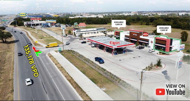

Current Lease Availabilities
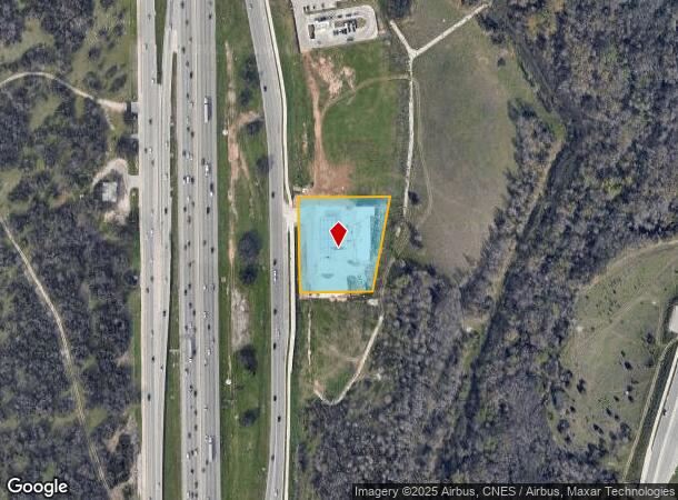
Property Detail
3523 N Interstate 35 N
Austin
Shops South Of University Oaks Blvd
Austin-Round Rock-San Marcos, TX
S12373 - SHOPS SOUTH OF UNIVERSITY OAKS BLVD, BLOCK A, LOT 5, ACRES 1.632
R600055
Williamson
Commercialnec
Texas
2024
5
2025
1.63 AC
020707
Round Rock
8,025 SF
NEARBY LISTINGS FOR SALE OR LEASE
DEMOGRAPHICS near 3523 N Interstate 35 N
1 mile
3 mile
5 mile
2024 Total Population
2,951
80,146
200,148
2029 Population
3,687
101,472
253,642
Pop Growth 2024-2029
+ 24.94%
+ 26.61%
+ 26.73%
Average Age
36
36
36
2024 Total Households
1,193
29,017
71,073
HH Growth 2024-2029
+ 25.65%
+ 27.23%
+ 27.30%
Median Household Inc
$79,444
$92,366
$99,897
Avg Household Size
2.50
2.70
2.80
2024 Avg HH Vehicles
2.00
2.00
2.00
Median Home Value
$480,391
$400,170
$392,406
Median Year Built
2007
2003
2003
Nearby Places
Map Layers
Map Styles
 Street
 Aerial
Transit
 Traffic
 Biking
Places
Listings with unknown addresses are not visible on the map
- Restaurants
- Banks
- Shops
- Fitness
- Groceries
PUBLIC TRANSPORTATION
AIRPORT
Austin-Bergstrom International
Drive
Walk
Distance
Austin-Bergstrom International
46 min
32.4 mi
Freight Ports
Calhoun Port
Drive
Walk
Distance
Calhoun Port
210 min
181.1 mi
Nearby Properties
Address
Land Use
TOTAL SIZE
Lot Size
Zoning
Address
Land Use
TOTAL SIZE
Lot Size
Zoning
489,460 SF
55.81 AC
PF3
Address
Land Use
TOTAL SIZE
Lot Size
Zoning
543,047 SF
76.14 AC
PUD
Address
Land Use
TOTAL SIZE
Lot Size
Zoning
215,033 SF
101 AC
HEC
Address
Land Use
TOTAL SIZE
Lot Size
Zoning
374,545 SF
38.86 AC
Address
Land Use
TOTAL SIZE
Lot Size
Zoning
536,741 SF
80.32 AC
SF2
Address
Land Use
TOTAL SIZE
Lot Size
Zoning
354,066 SF
40.51 AC
Address
Land Use
TOTAL SIZE
Lot Size
Zoning
345,000 SF
48.61 AC
Address
Land Use
TOTAL SIZE
Lot Size
Zoning
467,100 SF
35.12 AC
Address
Land Use
TOTAL SIZE
Lot Size
Zoning
533,151 SF
26.90 AC
PUD
Address
Land Use
TOTAL SIZE
Lot Size
Zoning
456,943 SF
66.31 AC
SF2
Address
Land Use
TOTAL SIZE
Lot Size
Zoning
374,225 SF
11.58 AC
Address
Land Use
TOTAL SIZE
Lot Size
Zoning
411,020 SF
29.91 AC
PUD
Address
Land Use
TOTAL SIZE
Lot Size
Zoning
331,518 SF
21.88 AC
Address
Land Use
TOTAL SIZE
Lot Size
Zoning
140,409 SF
17.15 AC
Address
Land Use
TOTAL SIZE
Lot Size
Zoning
301,452 SF
14.19 AC
Address
Land Use
TOTAL SIZE
Lot Size
Zoning
364,432 SF
20.56 AC
MF
Address
Land Use
TOTAL SIZE
Lot Size
Zoning
325,550 SF
15.42 AC
Address
Land Use
TOTAL SIZE
Lot Size
Zoning
379,701 SF
18.43 AC
Address
Land Use
TOTAL SIZE
Lot Size
Zoning
300,061 SF
19.19 AC
Address
Land Use
TOTAL SIZE
Lot Size
Zoning
295,680 SF
16 AC
MF
Address
Land Use
TOTAL SIZE
Lot Size
Zoning
299,400 SF
15.91 AC
MF
Address
Land Use
TOTAL SIZE
Lot Size
Zoning
330,300 SF
18.58 AC
C1
Address
Land Use
TOTAL SIZE
Lot Size
Zoning
446,815 SF
30.55 AC
Address
Land Use
TOTAL SIZE
Lot Size
Zoning
294,145 SF
14.46 AC
Address
Land Use
TOTAL SIZE
Lot Size
Zoning
285,760 SF
15.71 AC
Address
Land Use
TOTAL SIZE
Lot Size
Zoning
375,523 SF
15.43 AC
PUD
Address
Land Use
TOTAL SIZE
Lot Size
Zoning
217,013 SF
20.44 AC
Address
Land Use
TOTAL SIZE
Lot Size
Zoning
236,569 SF
26.86 AC
PUD
Address
Land Use
TOTAL SIZE
Lot Size
Zoning
395,492 SF
7.16 AC
Address
Land Use
TOTAL SIZE
Lot Size
Zoning
297,937 SF
14.44 AC
The World's #1 Commercial Real Estate Marketplace
Connect with us
© 2026 CoStar Group
The information above has been obtained from sources believed reliable. While we do not doubt its accuracy we have not verified it and make no guarantee, warranty or representation about it. It is your responsibility to independently confirm its accuracy and completeness. Any projections, opinions, assumptions, or estimates used are for example only and do not represent the current or future performance of the property. The value of this transaction to you depends on tax and other factors which should be evaluated by your tax, financial, and legal advisors. You and your advisors should conduct a careful, independent investigation of the property to determine to your satisfaction the suitability of the property for your needs.