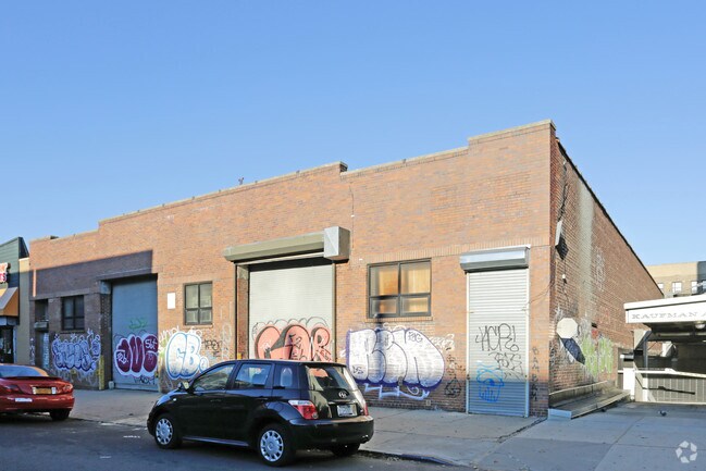
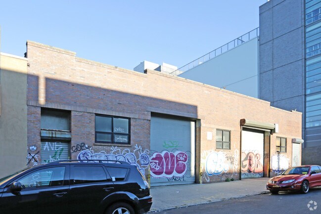
Property Record
3525 35Th St, Astoria, NY 11106

Save to a Folder
{{folder.Name}}
{{folder.ListingIds.length}} Properties
{{folder.ListingIds.length}} Property
Create a New Folder
Property Detail
3525 35Th St
00639-0013
Queens
Warehouse
New York
M1-5
13
B and X Area of moderate flood hazard, usually the area between the limits of the 100-year and 500-year floods.
0.34 AC
2025
Northwest Queens
2026
Long Island (New York)
005700
New York-Jersey City-White Plains, NY-NJ
8,625 SF
NEARBY LISTINGS FOR SALE OR LEASE
DEMOGRAPHICS near 3525 35Th St
1 mile
3 mile
5 mile
2025 Total Population
155,284
1,062,835
3,102,849
2030 Population
158,165
1,082,887
3,168,227
Pop Growth 2025-2030
+ 1.86%
+ 1.89%
+ 2.11%
Average Age
40
41
40
2025 Total Households
69,947
467,983
1,322,067
HH Growth 2025-2030
+ 1.63%
+ 2.45%
+ 2.63%
Median Household Inc
$91,008
$102,937
$91,803
Avg Household Size
2.10
2.20
2.20
2025 Avg HH Vehicles
.00
.00
.00
Median Home Value
$711,012
$897,517
$898,256
Median Year Built
1950
1956
1955
Nearby Places
Map Layers
Map Styles
 Street
 Aerial
Layers
 Traffic
 Biking
Places
Listings with unknown addresses are not visible on the map
- Restaurants
- Banks
- Shops
- Fitness
- Groceries
PUBLIC TRANSPORTATION
TRANSIT/SUBWAY
36 Street (E,G,R Line) (E - New York MTA Subway (The Subway), M - New York MTA Subway (The Subway), R - New York MTA Subway (The Subway))
Drive
Walk
Distance
36 Street (E,G,R Line) (E - New York MTA Subway (The Subway), M - New York MTA Subway (The Subway), R - New York MTA Subway (The Subway))
1 min
6 min
0.3 mi
36 Avenue (N - New York MTA Subway (The Subway), Q - New York MTA Subway (The Subway))
Drive
Walk
Distance
36 Avenue (N - New York MTA Subway (The Subway), Q - New York MTA Subway (The Subway))
1 min
6 min
0.3 mi
Steinway Street (E - New York MTA Subway (The Subway), G - New York MTA Subway (The Subway), M - New York MTA Subway (The Subway), R - New York MTA Subway (The Subway))
Drive
Walk
Distance
Steinway Street (E - New York MTA Subway (The Subway), G - New York MTA Subway (The Subway), M - New York MTA Subway (The Subway), R - New York MTA Subway (The Subway))
2 min
8 min
0.4 mi
39 Avenue (N - New York MTA Subway (The Subway), Q - New York MTA Subway (The Subway))
Drive
Walk
Distance
39 Avenue (N - New York MTA Subway (The Subway), Q - New York MTA Subway (The Subway))
2 min
11 min
0.6 mi
Broadway (N Line) (N - New York MTA Subway (The Subway), Q - New York MTA Subway (The Subway))
Drive
Walk
Distance
Broadway (N Line) (N - New York MTA Subway (The Subway), Q - New York MTA Subway (The Subway))
2 min
12 min
0.6 mi
COMMUTER RAIL
Hunterspoint Avenue Station (Hempstead Branch - Long Island Rail Road, Oyster Bay Branch - Long Island Rail Road)
Drive
Walk
Distance
Hunterspoint Avenue Station (Hempstead Branch - Long Island Rail Road, Oyster Bay Branch - Long Island Rail Road)
6 min
1.9 mi
Woodside Station (Babylon Branch - Long Island Rail Road, Far Rockaway Branch - Long Island Rail Road, Hempstead Branch - Long Island Rail Road, Long Beach Branch - Long Island Rail Road, Montauk Branch - Long Island Rail Road, Port Jefferson Branch - Long Island Rail Road, Port Washington Branch - Long Island Rail Road, Ronkonkoma Branch - Long Island Rail Road)
Drive
Walk
Distance
Woodside Station (Babylon Branch - Long Island Rail Road, Far Rockaway Branch - Long Island Rail Road, Hempstead Branch - Long Island Rail Road, Long Beach Branch - Long Island Rail Road, Montauk Branch - Long Island Rail Road, Port Jefferson Branch - Long Island Rail Road, Port Washington Branch - Long Island Rail Road, Ronkonkoma Branch - Long Island Rail Road)
6 min
2.2 mi
AIRPORT
LaGuardia
Drive
Walk
Distance
LaGuardia
10 min
4.0 mi
John F Kennedy International
Drive
Walk
Distance
John F Kennedy International
25 min
15.2 mi
Newark Liberty International
Drive
Walk
Distance
Newark Liberty International
30 min
18.4 mi
Freight Ports
NY - Red Hook Container Terminal
Drive
Walk
Distance
NY - Red Hook Container Terminal
19 min
8.5 mi
Nearby Properties
Address
Land Use
TOTAL SIZE
Lot Size
Zoning
Address
Land Use
TOTAL SIZE
Lot Size
Zoning
1,783,434 SF
1.94 AC
C5-3
Address
Land Use
TOTAL SIZE
Lot Size
Zoning
2,050,615 SF
1.84 AC
C5-3
Address
Land Use
TOTAL SIZE
Lot Size
Zoning
2,636,182 SF
2.35 AC
C65.5
Address
Land Use
TOTAL SIZE
Lot Size
Zoning
1,678,135 SF
1.01 AC
C5-3
Address
Land Use
TOTAL SIZE
Lot Size
Zoning
2,734,038 SF
4.24 AC
C52.5
Address
Land Use
TOTAL SIZE
Lot Size
Zoning
1,897,491 SF
2.06 AC
C52.5
Address
Land Use
TOTAL SIZE
Lot Size
Zoning
1,638,259 SF
1.43 AC
C52.5
Address
Land Use
TOTAL SIZE
Lot Size
Zoning
1,984,228 SF
1.95 AC
C65.5
Address
Land Use
TOTAL SIZE
Lot Size
Zoning
1,962,900 SF
1.89 AC
C66.5
Address
Land Use
TOTAL SIZE
Lot Size
Zoning
1,586,876 SF
1.87 AC
C5-3
Address
Land Use
TOTAL SIZE
Lot Size
Zoning
1,842,991 SF
2.08 AC
C66.5
Address
Land Use
TOTAL SIZE
Lot Size
Zoning
1,613,847 SF
1.84 AC
C66.5
Address
Land Use
TOTAL SIZE
Lot Size
Zoning
2,215,000 SF
6.43 AC
R9
Address
Land Use
TOTAL SIZE
Lot Size
Zoning
2,400,000 SF
15.14 AC
C5-2
Address
Land Use
TOTAL SIZE
Lot Size
Zoning
2,124,441 SF
17.29 AC
R8
Address
Land Use
TOTAL SIZE
Lot Size
Zoning
1,606,528 SF
1.84 AC
C6-6
Address
Land Use
TOTAL SIZE
Lot Size
Zoning
1,169,666 SF
1.42 AC
C52.5
Address
Land Use
TOTAL SIZE
Lot Size
Zoning
1,482,208 SF
1.71 AC
C5-3
Address
Land Use
TOTAL SIZE
Lot Size
Zoning
1,160,500 SF
1.62 AC
C6-6
Address
Land Use
TOTAL SIZE
Lot Size
Zoning
1,642,441 SF
3.26 AC
C52.5
Address
Land Use
TOTAL SIZE
Lot Size
Zoning
2,230,742 SF
6.33 AC
R9
Address
Land Use
TOTAL SIZE
Lot Size
Zoning
1,015,287 SF
1 AC
C5-3
Address
Land Use
TOTAL SIZE
Lot Size
Zoning
1,134,017 SF
1.05 AC
C5-3
Address
Land Use
TOTAL SIZE
Lot Size
Zoning
539,643 SF
C5-2
Address
Land Use
TOTAL SIZE
Lot Size
Zoning
822,014 SF
1.38 AC
C52.5
Address
Land Use
TOTAL SIZE
Lot Size
Zoning
1,033,031 SF
1.87 AC
C52.5
Address
Land Use
TOTAL SIZE
Lot Size
Zoning
916,553 SF
1.39 AC
C5-3
Address
Land Use
TOTAL SIZE
Lot Size
Zoning
685,125 SF
0.85 AC
C5-3
Address
Land Use
TOTAL SIZE
Lot Size
Zoning
782,503 SF
0.88 AC
C5-3
Address
Land Use
TOTAL SIZE
Lot Size
Zoning
1,064,223 SF
0.88 AC
C52.5
The World's #1 Commercial Real Estate Marketplace
Connect with us
© 2026 CoStar Group
The information above has been obtained from sources believed reliable. While we do not doubt its accuracy we have not verified it and make no guarantee, warranty or representation about it. It is your responsibility to independently confirm its accuracy and completeness. Any projections, opinions, assumptions, or estimates used are for example only and do not represent the current or future performance of the property. The value of this transaction to you depends on tax and other factors which should be evaluated by your tax, financial, and legal advisors. You and your advisors should conduct a careful, independent investigation of the property to determine to your satisfaction the suitability of the property for your needs.