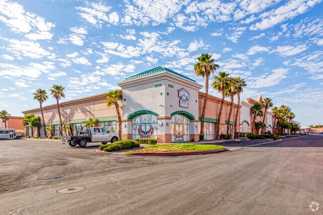
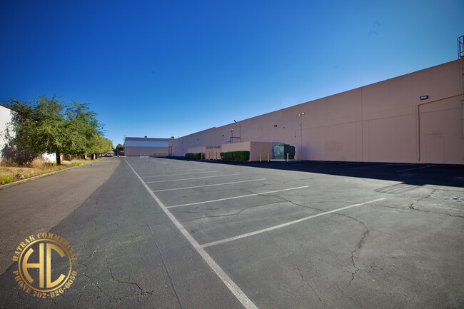
Property Record
3525 E Post Rd, Las Vegas, NV 89120


Property Detail
3525 E Post Rd
161-31-410-031
PECOS SUNSET COML PLAT BOOK 75 PAGE 44 PT LOT 1
Commercialnec
Clark
MD
Nevada
B and X Area of moderate flood hazard, usually the area between the limits of the 100-year and 500-year floods.
1
2026
2.97 AC
2026
Airport/E Las Vegas
006900
Las Vegas
53,644 SF
Las Vegas-Henderson-North Las Vegas, NV
NEARBY LISTINGS FOR SALE OR LEASE
DEMOGRAPHICS near 3525 E Post Rd
1 mile
3 mile
5 mile
2025 Total Population
8,172
154,089
420,273
2030 Population
8,563
160,856
439,063
Pop Growth 2025-2030
+ 4.78%
+ 4.39%
+ 4.47%
Average Age
43
41
41
2025 Total Households
3,446
61,436
171,072
HH Growth 2025-2030
+ 4.76%
+ 4.43%
+ 4.50%
Median Household Inc
$65,607
$71,445
$68,311
Avg Household Size
2.30
2.40
2.40
2025 Avg HH Vehicles
2.00
2.00
2.00
Median Home Value
$473,604
$423,335
$414,548
Median Year Built
1990
1988
1992
Nearby Places
Map Layers
Map Styles
 Street
 Aerial
Transit
 Traffic
 Biking
Places
Listings with unknown addresses are not visible on the map
- Restaurants
- Banks
- Shops
- Fitness
- Groceries
PUBLIC TRANSPORTATION
AIRPORT
Harry Reid International
Drive
Walk
Distance
Harry Reid International
10 min
4.3 mi
Boulder City Municipal
Drive
Walk
Distance
Boulder City Municipal
28 min
18.8 mi
Freight Ports
Port of Long Beach
Drive
Walk
Distance
Port of Long Beach
314 min
278.6 mi
SALE & LEASE HISTORY
LISTING DATE
SALE/LEASE

Sep 24, 2016
For Lease
Sep 20, 2017
For Lease
May 11, 2024
For Lease
Jun 11, 2019
For Lease
Jul 19, 2022
For Sale
Feb 03, 2022
For Lease
Aug 03, 2023
For Lease
Apr 06, 2017
For Lease
Nearby Properties
Address
Land Use
TOTAL SIZE
Lot Size
Zoning
Address
Land Use
TOTAL SIZE
Lot Size
Zoning
21,257 SF
12.72 AC
Address
Land Use
TOTAL SIZE
Lot Size
Zoning
44.69 AC
PF
Address
Land Use
TOTAL SIZE
Lot Size
Zoning
399,206 SF
22.06 AC
MD
Address
Land Use
TOTAL SIZE
Lot Size
Zoning
410,084 SF
16.74 AC
RH24
Address
Land Use
TOTAL SIZE
Lot Size
Zoning
95,928 SF
3.71 AC
C:U-V
Address
Land Use
TOTAL SIZE
Lot Size
Zoning
9,164 SF
22.81 AC
R3
Address
Land Use
TOTAL SIZE
Lot Size
Zoning
100.25 AC
RS1
Address
Land Use
TOTAL SIZE
Lot Size
Zoning
148.64 AC
PF
Address
Land Use
TOTAL SIZE
Lot Size
Zoning
8,891 SF
11.59 AC
Address
Land Use
TOTAL SIZE
Lot Size
Zoning
198.15 AC
PF
Address
Land Use
TOTAL SIZE
Lot Size
Zoning
4,460 SF
27.52 AC
Address
Land Use
TOTAL SIZE
Lot Size
Zoning
152.76 AC
PF
Address
Land Use
TOTAL SIZE
Lot Size
Zoning
43.37 AC
RS1
Address
Land Use
TOTAL SIZE
Lot Size
Zoning
100.43 AC
PF
Address
Land Use
TOTAL SIZE
Lot Size
Zoning
266,782 SF
8.83 AC
Address
Land Use
TOTAL SIZE
Lot Size
Zoning
13,589 SF
56.80 AC
PF
Address
Land Use
TOTAL SIZE
Lot Size
Zoning
4.18 AC
PF
Address
Land Use
TOTAL SIZE
Lot Size
Zoning
303,540 SF
4.99 AC
Address
Land Use
TOTAL SIZE
Lot Size
Zoning
213,048 SF
13.60 AC
Address
Land Use
TOTAL SIZE
Lot Size
Zoning
3,074 SF
18.46 AC
RH24
Address
Land Use
TOTAL SIZE
Lot Size
Zoning
334,698 SF
18.44 AC
MD
Address
Land Use
TOTAL SIZE
Lot Size
Zoning
3,040 SF
16.76 AC
R4
Address
Land Use
TOTAL SIZE
Lot Size
Zoning
7,304 SF
12.58 AC
R4
Address
Land Use
TOTAL SIZE
Lot Size
Zoning
6,548 SF
15.75 AC
RH24
Address
Land Use
TOTAL SIZE
Lot Size
Zoning
6,117 SF
14.90 AC
PF
Address
Land Use
TOTAL SIZE
Lot Size
Zoning
10,550 SF
15.79 AC
H:RH-24
Address
Land Use
TOTAL SIZE
Lot Size
Zoning
3,518 SF
14.69 AC
R4
Address
Land Use
TOTAL SIZE
Lot Size
Zoning
24,622 SF
14.28 AC
R4
Address
Land Use
TOTAL SIZE
Lot Size
Zoning
3,596 SF
8.50 AC
Address
Land Use
TOTAL SIZE
Lot Size
Zoning
17,640 SF
92.19 AC
PF
The World's #1 Commercial Real Estate Marketplace
Connect with us
© 2026 CoStar Group
The information above has been obtained from sources believed reliable. While we do not doubt its accuracy we have not verified it and make no guarantee, warranty or representation about it. It is your responsibility to independently confirm its accuracy and completeness. Any projections, opinions, assumptions, or estimates used are for example only and do not represent the current or future performance of the property. The value of this transaction to you depends on tax and other factors which should be evaluated by your tax, financial, and legal advisors. You and your advisors should conduct a careful, independent investigation of the property to determine to your satisfaction the suitability of the property for your needs.