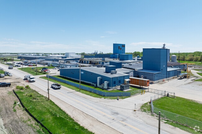
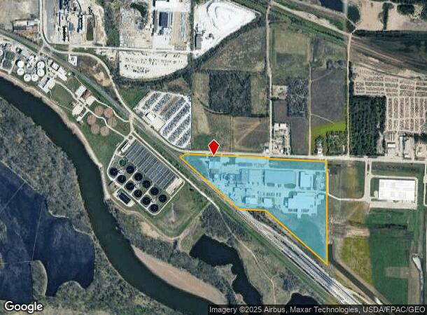
Property Record
3525 Vandalia Rd, Des Moines, IA 50317

NEARBY LISTINGS FOR SALE OR LEASE
Property Detail
3525 Vandalia Rd
Des Moines-West Des Moines, IA
Sec 18-78-23
050/04341-000-001
BEG 33F S & 110F W OF N 1/4 COR THN E 1371.78F S 880F W 442.2F NWLY ALNG NE LN RR ROW 1301.63F NELY 109.4F TO POB LOTS 1 & 2; & PARCEL A BOOK 14758 PAGE 650 BNG PRT OF LOTS 2, 3 & 4 HENDERSON ESTATE PLAT SEC 18-78-23
Warehouse
Polk
0
Iowa
2025
49.86 AC
005300
Northeast
475,929 SF
Des Moines
DEMOGRAPHICS near 3525 Vandalia Rd
1 Mile
3 Mile
5 Mile
2024 Total Population
0
37,217
128,297
2029 Population
0
38,512
133,628
Pop Growth 2024-2029
0.00%
+ 3.48%
+ 4.16%
Average Age
0
37
38
2024 Total Households
0
13,799
51,751
HH Growth 2024-2029
0.00%
+ 3.67%
+ 4.48%
Median Household Inc
$0
$65,116
$58,876
Avg Household Size
.00
2.60
2.40
2024 Avg HH Vehicles
.00
2.00
2.00
Median Home Value
$0
$170,469
$159,293
Median Year Built
0
1976
1972
Nearby Places
Map Layers
Map Styles
 Street
 Aerial
- Restaurants
- Banks
- Shops
- Fitness
- Groceries
PUBLIC TRANSPORTATION
AIRPORT
Des Moines International
DRIVE
WALK
Distance
Des Moines International
19 min
9.8 mi
Freight Ports
Port Milwaukee
DRIVE
WALK
Distance
Port Milwaukee
418 min
374.2 mi
Nearby Properties
Address
Land Use
TOTAL SIZE
Lot Size
Zoning
Address
Land Use
TOTAL SIZE
Lot Size
Zoning
177,094 SF
24.60 AC
Address
Land Use
TOTAL SIZE
Lot Size
Zoning
342,000 SF
22.18 AC
Address
Land Use
TOTAL SIZE
Lot Size
Zoning
218,593 SF
19.31 AC
M-2
Address
Land Use
TOTAL SIZE
Lot Size
Zoning
118,080 SF
15.76 AC
Address
Land Use
TOTAL SIZE
Lot Size
Zoning
175,854 SF
22.81 AC
Address
Land Use
TOTAL SIZE
Lot Size
Zoning
1,890,511 SF
39.03 AC
M-2
Address
Land Use
TOTAL SIZE
Lot Size
Zoning
178,415 SF
13.35 AC
R-6
Address
Land Use
TOTAL SIZE
Lot Size
Zoning
155,276 SF
6.66 AC
R-4
Address
Land Use
TOTAL SIZE
Lot Size
Zoning
201,072 SF
26.81 AC
Address
Land Use
TOTAL SIZE
Lot Size
Zoning
38.16 AC
PUD
Address
Land Use
TOTAL SIZE
Lot Size
Zoning
155,640 SF
9.15 AC
R-6
Address
Land Use
TOTAL SIZE
Lot Size
Zoning
138,490 SF
10.01 AC
R-6
Address
Land Use
TOTAL SIZE
Lot Size
Zoning
169,201 SF
13.66 AC
C-4
Address
Land Use
TOTAL SIZE
Lot Size
Zoning
65,079 SF
6.19 AC
R-2
Address
Land Use
TOTAL SIZE
Lot Size
Zoning
58,366 SF
11.58 AC
Address
Land Use
TOTAL SIZE
Lot Size
Zoning
89,286 SF
14.49 AC
R1-60
Address
Land Use
TOTAL SIZE
Lot Size
Zoning
111,166 SF
6.42 AC
M-1
Address
Land Use
TOTAL SIZE
Lot Size
Zoning
123,059 SF
27.23 AC
M2
Address
Land Use
TOTAL SIZE
Lot Size
Zoning
44,200 SF
3.41 AC
Address
Land Use
TOTAL SIZE
Lot Size
Zoning
57,475 SF
2.48 AC
PUD
Address
Land Use
TOTAL SIZE
Lot Size
Zoning
67,104 SF
4.04 AC
R-6
Address
Land Use
TOTAL SIZE
Lot Size
Zoning
107,190 SF
12.32 AC
C-4
Address
Land Use
TOTAL SIZE
Lot Size
Zoning
54,560 SF
4.83 AC
R-3
Address
Land Use
TOTAL SIZE
Lot Size
Zoning
1,326 SF
5.15 AC
I-3
Address
Land Use
TOTAL SIZE
Lot Size
Zoning
56,281 SF
5.80 AC
C-1
Address
Land Use
TOTAL SIZE
Lot Size
Zoning
16.80 AC
M-1
Address
Land Use
TOTAL SIZE
Lot Size
Zoning
49,708 SF
7.33 AC
R-3
Address
Land Use
TOTAL SIZE
Lot Size
Zoning
67,602 SF
3.71 AC
R-3
Address
Land Use
TOTAL SIZE
Lot Size
Zoning
34,562 SF
2.01 AC
R-3
The World's #1 Commercial Real Estate Marketplace
Connect with us
© 2026 CoStar Group
The information above has been obtained from sources believed reliable. While we do not doubt its accuracy we have not verified it and make no guarantee, warranty or representation about it. It is your responsibility to independently confirm its accuracy and completeness. Any projections, opinions, assumptions, or estimates used are for example only and do not represent the current or future performance of the property. The value of this transaction to you depends on tax and other factors which should be evaluated by your tax, financial, and legal advisors. You and your advisors should conduct a careful, independent investigation of the property to determine to your satisfaction the suitability of the property for your needs.