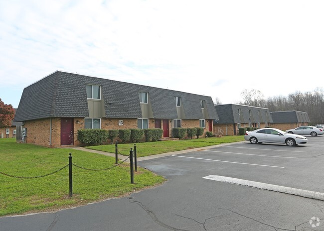
Property Record
3526 Highway 31 S, Decatur, AL 35603

Property Detail
3526 Highway 31 S
12-03-08-1-000-007.000
COM AT SW COR OF SW1/4 OF NE1/4 SEC 8, T6S, R4W, TH E 110', TH N ALG E R/W OF U.S. HWY #31 708.78' TO TPOB, TH CONT N 627', T
Apartmenthouse5plusunits
Morgan
AE The base floodplain where base flood elevations are provided. AE Zones are now used on new format FIRMs instead of A1-A30 Zones.
Alabama
2025
8 AC
2024
Alabama North Area
005109
Other Market Areas
7,722 SF
Decatur, AL
NEARBY LISTINGS FOR SALE OR LEASE
-
-
View all Decatur listings for sale on LoopNet.com
DEMOGRAPHICS near 3526 Highway 31 S
1 mile
3 mile
5 mile
2025 Total Population
1,692
23,176
59,392
2030 Population
1,708
23,411
60,388
Pop Growth 2025-2030
+ 0.95%
+ 1.01%
+ 1.68%
Average Age
36
40
41
2025 Total Households
648
9,694
24,087
HH Growth 2025-2030
+ 0.93%
+ 1.04%
+ 1.75%
Median Household Inc
$71,521
$70,299
$68,527
Avg Household Size
2.50
2.30
2.40
2025 Avg HH Vehicles
2.00
2.00
2.00
Median Home Value
$156,944
$218,933
$216,671
Median Year Built
1982
1980
1978
Nearby Places
Map Layers
Map Styles
 Street
 Aerial
Transit
 Traffic
 Biking
Places
Listings with unknown addresses are not visible on the map
- Restaurants
- Banks
- Shops
- Fitness
- Groceries
PUBLIC TRANSPORTATION
AIRPORT
Huntsville International-Carl T Jones Field
Drive
Walk
Distance
Huntsville International-Carl T Jones Field
31 min
20.2 mi
Freight Ports
Port of Mobile
Drive
Walk
Distance
Port of Mobile
365 min
331.3 mi
Nearby Properties
Address
Land Use
TOTAL SIZE
Lot Size
Zoning
Address
Land Use
TOTAL SIZE
Lot Size
Zoning
157,720 SF
22 AC
Address
Land Use
TOTAL SIZE
Lot Size
Zoning
128,239 SF
7.10 AC
Address
Land Use
TOTAL SIZE
Lot Size
Zoning
51,958 SF
14 AC
Address
Land Use
TOTAL SIZE
Lot Size
Zoning
81,682 SF
13 AC
Address
Land Use
TOTAL SIZE
Lot Size
Zoning
205,279 SF
25.45 AC
Address
Land Use
TOTAL SIZE
Lot Size
Zoning
54,352 SF
10.70 AC
Address
Land Use
TOTAL SIZE
Lot Size
Zoning
40,712 SF
12 AC
Address
Land Use
TOTAL SIZE
Lot Size
Zoning
2,546 SF
9.30 AC
Address
Land Use
TOTAL SIZE
Lot Size
Zoning
64,449 SF
12 AC
Address
Land Use
TOTAL SIZE
Lot Size
Zoning
19,239 SF
4.50 AC
Address
Land Use
TOTAL SIZE
Lot Size
Zoning
52,800 SF
14.50 AC
Address
Land Use
TOTAL SIZE
Lot Size
Zoning
55,283 SF
4.48 AC
Address
Land Use
TOTAL SIZE
Lot Size
Zoning
175,314 SF
Address
Land Use
TOTAL SIZE
Lot Size
Zoning
77,811 SF
9.34 AC
Address
Land Use
TOTAL SIZE
Lot Size
Zoning
6,800 SF
4.18 AC
Address
Land Use
TOTAL SIZE
Lot Size
Zoning
100,525 SF
10.80 AC
Address
Land Use
TOTAL SIZE
Lot Size
Zoning
48,536 SF
7.24 AC
Address
Land Use
TOTAL SIZE
Lot Size
Zoning
35,498 SF
4.70 AC
Address
Land Use
TOTAL SIZE
Lot Size
Zoning
54,705 SF
4.79 AC
Address
Land Use
TOTAL SIZE
Lot Size
Zoning
58,500 SF
3.50 AC
Address
Land Use
TOTAL SIZE
Lot Size
Zoning
2,805 SF
8.20 AC
Address
Land Use
TOTAL SIZE
Lot Size
Zoning
31,920 SF
3.90 AC
Address
Land Use
TOTAL SIZE
Lot Size
Zoning
12,744 SF
3.19 AC
Address
Land Use
TOTAL SIZE
Lot Size
Zoning
11,740 SF
3.67 AC
Address
Land Use
TOTAL SIZE
Lot Size
Zoning
61,217 SF
5.80 AC
Address
Land Use
TOTAL SIZE
Lot Size
Zoning
63,775 SF
13.70 AC
Address
Land Use
TOTAL SIZE
Lot Size
Zoning
2,540 SF
5.38 AC
Address
Land Use
TOTAL SIZE
Lot Size
Zoning
56,580 SF
8.20 AC
Address
Land Use
TOTAL SIZE
Lot Size
Zoning
12,500 SF
4.90 AC
Address
Land Use
TOTAL SIZE
Lot Size
Zoning
392 SF
123 AC
The World's #1 Commercial Real Estate Marketplace
Connect with us
© 2026 CoStar Group
The information above has been obtained from sources believed reliable. While we do not doubt its accuracy we have not verified it and make no guarantee, warranty or representation about it. It is your responsibility to independently confirm its accuracy and completeness. Any projections, opinions, assumptions, or estimates used are for example only and do not represent the current or future performance of the property. The value of this transaction to you depends on tax and other factors which should be evaluated by your tax, financial, and legal advisors. You and your advisors should conduct a careful, independent investigation of the property to determine to your satisfaction the suitability of the property for your needs.