Property Record
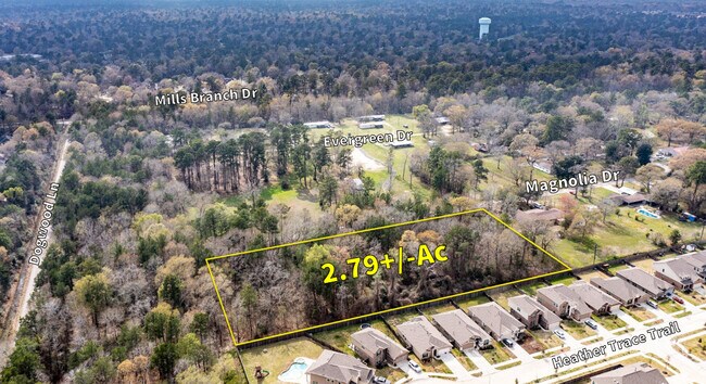
3527 Magnolia Dr, Porter, TX 77365

Property Detail
3527 Magnolia Dr
Houston-Pasadena-The Woodlands, TX
LT 14 WORLEY ACRES U/R
0962500000013
HARRIS
Vacantlandnec
Texas
B and X Area of moderate flood hazard, usually the area between the limits of the 100-year and 500-year floods.
14
2025
0.92 AC
2025
Kingwood/Humble
251501
Houston
NEARBY LISTINGS FOR SALE OR LEASE
DEMOGRAPHICS near 3527 Magnolia Dr
1 mile
3 mile
5 mile
2025 Total Population
11,866
58,084
125,357
2030 Population
12,688
62,848
138,800
Pop Growth 2025-2030
+ 6.93%
+ 8.20%
+ 10.72%
Average Age
38
39
39
2025 Total Households
3,794
20,362
45,458
HH Growth 2025-2030
+ 7.12%
+ 8.53%
+ 11.30%
Median Household Inc
$138,522
$109,540
$99,634
Avg Household Size
3.10
2.80
2.70
2025 Avg HH Vehicles
2.00
2.00
2.00
Median Home Value
$338,059
$329,578
$327,818
Median Year Built
1996
1989
1997
Nearby Places
Map Layers
Map Styles
 Street
 Aerial
Layers
 Traffic
 Biking
Places
Listings with unknown addresses are not visible on the map
- Restaurants
- Banks
- Shops
- Fitness
- Groceries
PUBLIC TRANSPORTATION
AIRPORT
George Bush Intcntl/Houston
Drive
Walk
Distance
George Bush Intcntl/Houston
29 min
18.7 mi
Freight Ports
Port of Houston
Drive
Walk
Distance
Port of Houston
50 min
34.0 mi
SALE & LEASE HISTORY
LISTING DATE
SALE/LEASE

Apr 02, 2024
For Sale
Nearby Properties
Address
Land Use
TOTAL SIZE
Lot Size
Zoning
Address
Land Use
TOTAL SIZE
Lot Size
Zoning
515,340 SF
20.32 AC
Address
Land Use
TOTAL SIZE
Lot Size
Zoning
367,951 SF
26.50 AC
Address
Land Use
TOTAL SIZE
Lot Size
Zoning
130,934 SF
10.71 AC
Address
Land Use
TOTAL SIZE
Lot Size
Zoning
60,584 SF
9.14 AC
Address
Land Use
TOTAL SIZE
Lot Size
Zoning
256,120 SF
9.81 AC
Address
Land Use
TOTAL SIZE
Lot Size
Zoning
106,147 SF
14.03 AC
Address
Land Use
TOTAL SIZE
Lot Size
Zoning
128,976 SF
16.99 AC
Address
Land Use
TOTAL SIZE
Lot Size
Zoning
190,424 SF
23 AC
Address
Land Use
TOTAL SIZE
Lot Size
Zoning
126,879 SF
12.13 AC
Address
Land Use
TOTAL SIZE
Lot Size
Zoning
139,496 SF
7.43 AC
Address
Land Use
TOTAL SIZE
Lot Size
Zoning
126,662 SF
6.08 AC
Address
Land Use
TOTAL SIZE
Lot Size
Zoning
43,660 SF
3.10 AC
Address
Land Use
TOTAL SIZE
Lot Size
Zoning
128,079 SF
5.30 AC
Address
Land Use
TOTAL SIZE
Lot Size
Zoning
13,238 SF
35 AC
Address
Land Use
TOTAL SIZE
Lot Size
Zoning
20,440 SF
2.01 AC
Address
Land Use
TOTAL SIZE
Lot Size
Zoning
67,298 SF
7.06 AC
Address
Land Use
TOTAL SIZE
Lot Size
Zoning
55,023 SF
5.58 AC
Address
Land Use
TOTAL SIZE
Lot Size
Zoning
72,806 SF
2.15 AC
Address
Land Use
TOTAL SIZE
Lot Size
Zoning
58,907 SF
3.57 AC
Address
Land Use
TOTAL SIZE
Lot Size
Zoning
27,456 SF
2.50 AC
Address
Land Use
TOTAL SIZE
Lot Size
Zoning
28,000 SF
8.38 AC
Address
Land Use
TOTAL SIZE
Lot Size
Zoning
109,072 SF
6.05 AC
5
Address
Land Use
TOTAL SIZE
Lot Size
Zoning
19,979 SF
15.23 AC
Address
Land Use
TOTAL SIZE
Lot Size
Zoning
63,439 SF
8.13 AC
5
Address
Land Use
TOTAL SIZE
Lot Size
Zoning
20,620 SF
1.73 AC
Address
Land Use
TOTAL SIZE
Lot Size
Zoning
40,191 SF
5.61 AC
Address
Land Use
TOTAL SIZE
Lot Size
Zoning
22,192 SF
1.87 AC
Address
Land Use
TOTAL SIZE
Lot Size
Zoning
22,400 SF
11.75 AC
5
Address
Land Use
TOTAL SIZE
Lot Size
Zoning
25,440 SF
1.70 AC
Address
Land Use
TOTAL SIZE
Lot Size
Zoning
14,808 SF
0.76 AC
The World's #1 Commercial Real Estate Marketplace
Connect with us
© 2026 CoStar Group
The information above has been obtained from sources believed reliable. While we do not doubt its accuracy we have not verified it and make no guarantee, warranty or representation about it. It is your responsibility to independently confirm its accuracy and completeness. Any projections, opinions, assumptions, or estimates used are for example only and do not represent the current or future performance of the property. The value of this transaction to you depends on tax and other factors which should be evaluated by your tax, financial, and legal advisors. You and your advisors should conduct a careful, independent investigation of the property to determine to your satisfaction the suitability of the property for your needs.