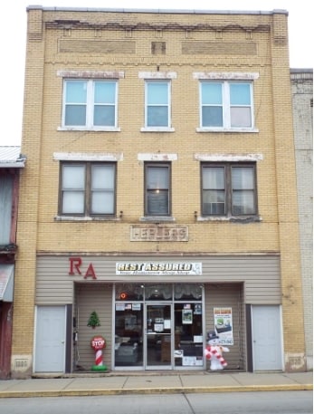
Property Record
351 Broad St, New Bethlehem, PA 16242
NEARBY LISTINGS FOR SALE OR LEASE
-
-
View all New Bethlehem listings for sale on LoopNet.com
Property Detail
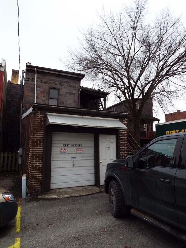
351 Broad St
Commercialnec
LOT
X
Clarion
42005C0114D
Pennsylvania
2025
0.11 AC
2025
Pennsylvania Central Area
160800
Other Market Areas
1,426 SF
020-004560
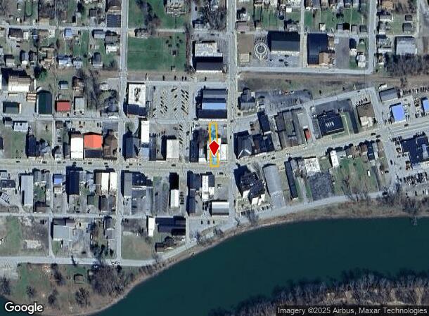
DEMOGRAPHICS near 351 Broad St
1 Mile
3 Mile
5 Mile
2024 Total Population
1,760
3,391
5,237
2029 Population
1,710
3,290
5,085
Pop Growth 2024-2029
(2.84%)
(2.98%)
(2.90%)
Average Age
44
44
44
2024 Total Households
799
1,481
2,253
HH Growth 2024-2029
(2.63%)
(2.77%)
(2.75%)
Median Household Inc
$45,357
$49,520
$51,275
Avg Household Size
2.20
2.30
2.30
2024 Avg HH Vehicles
2.00
2.00
2.00
Median Home Value
$105,851
$109,941
$116,635
Median Year Built
1950
1951
1952
Nearby Places
Map Layers
Map Styles
 Street
 Aerial
- Restaurants
- Banks
- Shops
- Fitness
- Groceries
SALE & LEASE HISTORY
LISTING DATE
SALE/LEASE

Dec 18, 2019
For Sale
Nearby Properties
Address
Land Use
TOTAL SIZE
Lot Size
Zoning
Address
Land Use
TOTAL SIZE
Lot Size
Zoning
19.80 AC
Address
Land Use
TOTAL SIZE
Lot Size
Zoning
11.20 AC
Address
Land Use
TOTAL SIZE
Lot Size
Zoning
6,747 SF
0.52 AC
Address
Land Use
TOTAL SIZE
Lot Size
Zoning
15,414 SF
0.40 AC
Address
Land Use
TOTAL SIZE
Lot Size
Zoning
22,787 SF
2.88 AC
Address
Land Use
TOTAL SIZE
Lot Size
Zoning
9,952 SF
1.43 AC
Address
Land Use
TOTAL SIZE
Lot Size
Zoning
0.67 AC
Address
Land Use
TOTAL SIZE
Lot Size
Zoning
432 SF
0.43 AC
Address
Land Use
TOTAL SIZE
Lot Size
Zoning
10,652 SF
3.51 AC
Address
Land Use
TOTAL SIZE
Lot Size
Zoning
8,434 SF
4.50 AC
Address
Land Use
TOTAL SIZE
Lot Size
Zoning
Address
Land Use
TOTAL SIZE
Lot Size
Zoning
81,250 SF
9.41 AC
Address
Land Use
TOTAL SIZE
Lot Size
Zoning
5,624 SF
0.57 AC
Address
Land Use
TOTAL SIZE
Lot Size
Zoning
5,655 SF
0.12 AC
Address
Land Use
TOTAL SIZE
Lot Size
Zoning
10.92 AC
Address
Land Use
TOTAL SIZE
Lot Size
Zoning
Address
Land Use
TOTAL SIZE
Lot Size
Zoning
33.50 AC
Address
Land Use
TOTAL SIZE
Lot Size
Zoning
12,000 SF
1.38 AC
Address
Land Use
TOTAL SIZE
Lot Size
Zoning
Address
Land Use
TOTAL SIZE
Lot Size
Zoning
0.50 AC
Address
Land Use
TOTAL SIZE
Lot Size
Zoning
12,672 SF
0.78 AC
Address
Land Use
TOTAL SIZE
Lot Size
Zoning
8,023 SF
1.77 AC
Address
Land Use
TOTAL SIZE
Lot Size
Zoning
9,831 SF
0.62 AC
Address
Land Use
TOTAL SIZE
Lot Size
Zoning
6,272 SF
0.23 AC
Address
Land Use
TOTAL SIZE
Lot Size
Zoning
1,098.64 AC
Address
Land Use
TOTAL SIZE
Lot Size
Zoning
29.61 AC
Address
Land Use
TOTAL SIZE
Lot Size
Zoning
10,230 SF
0.75 AC
Address
Land Use
TOTAL SIZE
Lot Size
Zoning
0.25 AC
Address
Land Use
TOTAL SIZE
Lot Size
Zoning
Address
Land Use
TOTAL SIZE
Lot Size
Zoning
12,000 SF
2.31 AC
The World's #1 Commercial Real Estate Marketplace
Connect with us
© 2025 CoStar Group
The information above has been obtained from sources believed reliable. While we do not doubt its accuracy we have not verified it and make no guarantee, warranty or representation about it. It is your responsibility to independently confirm its accuracy and completeness. Any projections, opinions, assumptions, or estimates used are for example only and do not represent the current or future performance of the property. The value of this transaction to you depends on tax and other factors which should be evaluated by your tax, financial, and legal advisors. You and your advisors should conduct a careful, independent investigation of the property to determine to your satisfaction the suitability of the property for your needs.