Property Record
353 Main St, Spotswood, NJ 08884
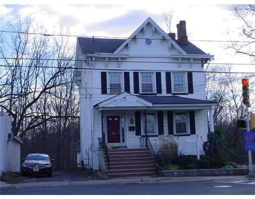
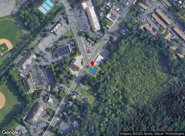
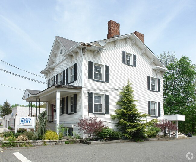

This Property Is For Sale
NEARBY LISTINGS FOR SALE OR LEASE
-
-
-
-
-
-
-
-
No Photo
-
-
View all Spotswood listings for sale on LoopNet.com
Property Detail
353 Main St
New York-Jersey City-White Plains, NY-NJ
Middlesex
24-00108-0000-00035
New Jersey
Sfr
0.23 AC
X
Brunswick
34023C0144F
Northern New Jersey
1,615 SF
DEMOGRAPHICS near 353 Main St
1 Mile
3 Mile
5 Mile
2024 Total Population
7,898
74,061
155,413
2029 Population
7,865
73,649
154,866
Pop Growth 2024-2029
(0.42%)
(0.56%)
(0.35%)
Average Age
42
41
41
2024 Total Households
2,880
25,889
55,039
HH Growth 2024-2029
(0.56%)
(0.71%)
(0.47%)
Median Household Inc
$107,410
$114,389
$109,819
Avg Household Size
2.70
2.80
2.80
2024 Avg HH Vehicles
2.00
2.00
2.00
Median Home Value
$373,424
$423,218
$428,062
Median Year Built
1962
1974
1973
Nearby Places
- Restaurants
- Banks
- Shops
- Fitness
- Groceries
PUBLIC TRANSPORTATION
COMMUTER RAIL
New Brunswick (Northeast Corridor Line - NJ Transit Commuter Rail (NJ Transit))
DRIVE
WALK
Distance
New Brunswick (Northeast Corridor Line - NJ Transit Commuter Rail (NJ Transit))
16 min
9.6 mi
AIRPORT
Trenton Mercer
DRIVE
WALK
Distance
Trenton Mercer
48 min
30.3 mi
Newark Liberty International
DRIVE
WALK
Distance
Newark Liberty International
44 min
31.7 mi
Freight Ports
New York Container Terminal
DRIVE
WALK
Distance
New York Container Terminal
37 min
26.8 mi
Nearby Properties
Address
Land Use
TOTAL SIZE
Lot Size
Zoning
Address
Land Use
TOTAL SIZE
Lot Size
Zoning
176.53 AC
G1
Address
Land Use
TOTAL SIZE
Lot Size
Zoning
Address
Land Use
TOTAL SIZE
Lot Size
Zoning
0.17 AC
R15
Address
Land Use
TOTAL SIZE
Lot Size
Zoning
160,986 SF
60.24 AC
Address
Land Use
TOTAL SIZE
Lot Size
Zoning
5.10 AC
Address
Land Use
TOTAL SIZE
Lot Size
Zoning
245,980 SF
54.02 AC
OP1
Address
Land Use
TOTAL SIZE
Lot Size
Zoning
7,701 SF
38.78 AC
R30
Address
Land Use
TOTAL SIZE
Lot Size
Zoning
8,512 SF
65.36 AC
MH
Address
Land Use
TOTAL SIZE
Lot Size
Zoning
7,801 SF
9.26 AC
CN
Address
Land Use
TOTAL SIZE
Lot Size
Zoning
12.01 AC
Address
Land Use
TOTAL SIZE
Lot Size
Zoning
7,702 SF
23 AC
AF
Address
Land Use
TOTAL SIZE
Lot Size
Zoning
2.53 AC
HR
Address
Land Use
TOTAL SIZE
Lot Size
Zoning
93,180 SF
0.65 AC
C-4
Address
Land Use
TOTAL SIZE
Lot Size
Zoning
7,702 SF
20.75 AC
AF
Address
Land Use
TOTAL SIZE
Lot Size
Zoning
29.98 AC
O1
Address
Land Use
TOTAL SIZE
Lot Size
Zoning
64,544 SF
7.62 AC
C-2
Address
Land Use
TOTAL SIZE
Lot Size
Zoning
7,803 SF
16.70 AC
R6
Address
Land Use
TOTAL SIZE
Lot Size
Zoning
219,430 SF
16.50 AC
HC2
Address
Land Use
TOTAL SIZE
Lot Size
Zoning
282,731 SF
24.96 AC
HC2
Address
Land Use
TOTAL SIZE
Lot Size
Zoning
13.01 AC
HC3
Address
Land Use
TOTAL SIZE
Lot Size
Zoning
62.23 AC
R2
Address
Land Use
TOTAL SIZE
Lot Size
Zoning
2,880 SF
50.86 AC
H1
Address
Land Use
TOTAL SIZE
Lot Size
Zoning
88,177 SF
20.40 AC
R30
Address
Land Use
TOTAL SIZE
Lot Size
Zoning
19,110 SF
0.29 AC
C-3B
Address
Land Use
TOTAL SIZE
Lot Size
Zoning
11.79 AC
VG3
Address
Land Use
TOTAL SIZE
Lot Size
Zoning
Address
Land Use
TOTAL SIZE
Lot Size
Zoning
179,144 SF
24.40 AC
LI
Address
Land Use
TOTAL SIZE
Lot Size
Zoning
115,636 SF
5.31 AC
SC
Address
Land Use
TOTAL SIZE
Lot Size
Zoning
77,981 SF
14.96 AC
Address
Land Use
TOTAL SIZE
Lot Size
Zoning
62,591 SF
19.89 AC
FHC
The World's #1 Commercial Real Estate Marketplace
Connect with us
© 2025 CoStar Group
The information above has been obtained from sources believed reliable. While we do not doubt its accuracy we have not verified it and make no guarantee, warranty or representation about it. It is your responsibility to independently confirm its accuracy and completeness. Any projections, opinions, assumptions, or estimates used are for example only and do not represent the current or future performance of the property. The value of this transaction to you depends on tax and other factors which should be evaluated by your tax, financial, and legal advisors. You and your advisors should conduct a careful, independent investigation of the property to determine to your satisfaction the suitability of the property for your needs.