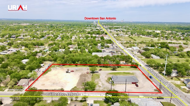
Property Record
119 Gillette Blvd, San Antonio, TX 78221
NEARBY LISTINGS FOR SALE OR LEASE
Property Detail
119 Gillette Blvd
San Antonio-New Braunfels, TX
Conv A/S Code
11114-015-0060
NCB 11114 BLK 15 LOT 4
Vacantlandnec
Bexar
X
Texas
48029C0560F
41
2024
0.14 AC
2025
South
151700
San Antonio
DEMOGRAPHICS near 119 Gillette Blvd
1 Mile
3 Mile
5 Mile
2024 Total Population
11,643
70,607
182,083
2029 Population
12,349
74,786
194,145
Pop Growth 2024-2029
+ 6.06%
+ 5.92%
+ 6.62%
Average Age
36
36
37
2024 Total Households
3,588
22,648
61,065
HH Growth 2024-2029
+ 6.16%
+ 6.08%
+ 6.76%
Median Household Inc
$54,217
$49,402
$43,860
Avg Household Size
3.10
3.00
2.90
2024 Avg HH Vehicles
2.00
2.00
2.00
Median Home Value
$141,708
$134,763
$125,925
Median Year Built
1974
1970
1965
Nearby Places
Map Layers
Map Styles
 Street
 Aerial
- Restaurants
- Banks
- Shops
- Fitness
- Groceries
PUBLIC TRANSPORTATION
COMMUTER RAIL
San Antonio Amtrak Station (Sunset Limited - Amtrak, Texas Eagle - Amtrak)
DRIVE
WALK
Distance
San Antonio Amtrak Station (Sunset Limited - Amtrak, Texas Eagle - Amtrak)
15 min
8.0 mi
AIRPORT
San Antonio International
DRIVE
WALK
Distance
San Antonio International
24 min
15.4 mi
Freight Ports
Port of Corpus Christi
DRIVE
WALK
Distance
Port of Corpus Christi
145 min
140.8 mi
SALE & LEASE HISTORY
LISTING DATE
SALE/LEASE

Apr 22, 2024
For Sale
Apr 21, 2023
For Sale
Nearby Properties
Address
Land Use
TOTAL SIZE
Lot Size
Zoning
Address
Land Use
TOTAL SIZE
Lot Size
Zoning
32,800 SF
198.68 AC
Address
Land Use
TOTAL SIZE
Lot Size
Zoning
548,048 SF
27.53 AC
Address
Land Use
TOTAL SIZE
Lot Size
Zoning
12,504,292 SF
32.18 AC
Address
Land Use
TOTAL SIZE
Lot Size
Zoning
504,337 SF
45.55 AC
Address
Land Use
TOTAL SIZE
Lot Size
Zoning
447,169 SF
46.74 AC
Address
Land Use
TOTAL SIZE
Lot Size
Zoning
163.70 AC
Address
Land Use
TOTAL SIZE
Lot Size
Zoning
211,365 SF
11.65 AC
Address
Land Use
TOTAL SIZE
Lot Size
Zoning
71,607 SF
10.46 AC
Address
Land Use
TOTAL SIZE
Lot Size
Zoning
218,003 SF
12.33 AC
Address
Land Use
TOTAL SIZE
Lot Size
Zoning
11,553 SF
67.15 AC
Address
Land Use
TOTAL SIZE
Lot Size
Zoning
80,936 SF
13.48 AC
Address
Land Use
TOTAL SIZE
Lot Size
Zoning
45,363 SF
4.29 AC
Address
Land Use
TOTAL SIZE
Lot Size
Zoning
143,067 SF
11.69 AC
Address
Land Use
TOTAL SIZE
Lot Size
Zoning
56,875 SF
10.04 AC
Address
Land Use
TOTAL SIZE
Lot Size
Zoning
526.61 AC
Address
Land Use
TOTAL SIZE
Lot Size
Zoning
166,270 SF
13.95 AC
Address
Land Use
TOTAL SIZE
Lot Size
Zoning
38,671 SF
5.20 AC
Address
Land Use
TOTAL SIZE
Lot Size
Zoning
141,606 SF
13.74 AC
Address
Land Use
TOTAL SIZE
Lot Size
Zoning
67,184 SF
60.16 AC
Address
Land Use
TOTAL SIZE
Lot Size
Zoning
203,232 SF
24.20 AC
Address
Land Use
TOTAL SIZE
Lot Size
Zoning
244,072 SF
13.97 AC
Address
Land Use
TOTAL SIZE
Lot Size
Zoning
109,591 SF
5.65 AC
Address
Land Use
TOTAL SIZE
Lot Size
Zoning
47.74 AC
Address
Land Use
TOTAL SIZE
Lot Size
Zoning
154,556 SF
7.52 AC
Address
Land Use
TOTAL SIZE
Lot Size
Zoning
73,178 SF
23.11 AC
Address
Land Use
TOTAL SIZE
Lot Size
Zoning
144,137 SF
10.44 AC
Address
Land Use
TOTAL SIZE
Lot Size
Zoning
34,344 SF
9.79 AC
Address
Land Use
TOTAL SIZE
Lot Size
Zoning
72,868 SF
14.79 AC
Address
Land Use
TOTAL SIZE
Lot Size
Zoning
51,960 SF
8 AC
Address
Land Use
TOTAL SIZE
Lot Size
Zoning
120,339 SF
7.28 AC
The World's #1 Commercial Real Estate Marketplace
Connect with us
© 2025 CoStar Group
The information above has been obtained from sources believed reliable. While we do not doubt its accuracy we have not verified it and make no guarantee, warranty or representation about it. It is your responsibility to independently confirm its accuracy and completeness. Any projections, opinions, assumptions, or estimates used are for example only and do not represent the current or future performance of the property. The value of this transaction to you depends on tax and other factors which should be evaluated by your tax, financial, and legal advisors. You and your advisors should conduct a careful, independent investigation of the property to determine to your satisfaction the suitability of the property for your needs.