Property Record
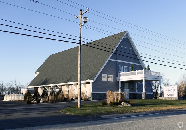
353 Pine Point Rd, Scarborough, ME 04074


This Property Is For Sale
Property Detail
353 Pine Point Rd
SCAR-000087R-000000-000003
Cumberland
Restaurantbuilding
Maine
22
3
AE The base floodplain where base flood elevations are provided. AE Zones are now used on new format FIRMs instead of A1-A30 Zones.
3.22 AC
2025
SW Cumberland County
2025
Portland/South Portland
017307
Portland-South Portland, ME
11,799 SF
NEARBY LISTINGS FOR SALE OR LEASE
-
-
View all Scarborough listings for sale on LoopNet.com
DEMOGRAPHICS near 353 Pine Point Rd
1 mile
3 mile
5 mile
2025 Total Population
1,755
14,801
36,316
2030 Population
1,928
15,722
37,890
Pop Growth 2025-2030
+ 9.86%
+ 6.22%
+ 4.33%
Average Age
50
48
47
2025 Total Households
854
6,955
16,647
HH Growth 2025-2030
+ 10.66%
+ 6.74%
+ 4.71%
Median Household Inc
$113,928
$103,768
$101,519
Avg Household Size
2.00
2.10
2.10
2025 Avg HH Vehicles
2.00
2.00
2.00
Median Home Value
$726,351
$516,760
$486,837
Median Year Built
1969
1980
1985
Nearby Places
Map Layers
Map Styles
 Street
 Aerial
Layers
 Traffic
 Biking
Places
Listings with unknown addresses are not visible on the map
- Restaurants
- Banks
- Shops
- Fitness
- Groceries
PUBLIC TRANSPORTATION
COMMUTER RAIL
Saco Amtrak Station (Downeaster - Amtrak)
Drive
Walk
Distance
Saco Amtrak Station (Downeaster - Amtrak)
14 min
7.2 mi
AIRPORT
Portland International Jetport
Drive
Walk
Distance
Portland International Jetport
22 min
11.5 mi
Freight Ports
Portland, ME
Drive
Walk
Distance
Portland, ME
23 min
14.1 mi
Nearby Properties
Address
Land Use
TOTAL SIZE
Lot Size
Zoning
Address
Land Use
TOTAL SIZE
Lot Size
Zoning
113,025 SF
7.30 AC
31
Address
Land Use
TOTAL SIZE
Lot Size
Zoning
8,983 SF
1.15 AC
12
Address
Land Use
TOTAL SIZE
Lot Size
Zoning
2.50 AC
R-1
Address
Land Use
TOTAL SIZE
Lot Size
Zoning
67.20 AC
36
Address
Land Use
TOTAL SIZE
Lot Size
Zoning
19,725 SF
45.64 AC
16
Address
Land Use
TOTAL SIZE
Lot Size
Zoning
3,033 SF
55.01 AC
RD
Address
Land Use
TOTAL SIZE
Lot Size
Zoning
49,840 SF
24 AC
21
Address
Land Use
TOTAL SIZE
Lot Size
Zoning
49,600 SF
22.06 AC
21
Address
Land Use
TOTAL SIZE
Lot Size
Zoning
1,076 SF
52.56 AC
12
Address
Land Use
TOTAL SIZE
Lot Size
Zoning
7,714 SF
1.27 AC
12
Address
Land Use
TOTAL SIZE
Lot Size
Zoning
2,922 SF
1.20 AC
12
Address
Land Use
TOTAL SIZE
Lot Size
Zoning
12,794 SF
2.03 AC
12
Address
Land Use
TOTAL SIZE
Lot Size
Zoning
47,532 SF
4.76 AC
MZ
Address
Land Use
TOTAL SIZE
Lot Size
Zoning
27.06 AC
16
Address
Land Use
TOTAL SIZE
Lot Size
Zoning
75,288 SF
6.27 AC
Address
Land Use
TOTAL SIZE
Lot Size
Zoning
5,000 SF
8.30 AC
PMUD
Address
Land Use
TOTAL SIZE
Lot Size
Zoning
14.62 AC
31
Address
Land Use
TOTAL SIZE
Lot Size
Zoning
8,007 SF
1.04 AC
12
Address
Land Use
TOTAL SIZE
Lot Size
Zoning
24,192 SF
1.80 AC
BRD
Address
Land Use
TOTAL SIZE
Lot Size
Zoning
1,768 SF
21.12 AC
MZ
Address
Land Use
TOTAL SIZE
Lot Size
Zoning
7,064 SF
0.66 AC
12
Address
Land Use
TOTAL SIZE
Lot Size
Zoning
2,704 SF
17 AC
12
Address
Land Use
TOTAL SIZE
Lot Size
Zoning
5,256 SF
0.80 AC
12
Address
Land Use
TOTAL SIZE
Lot Size
Zoning
5.98 AC
MU3
Address
Land Use
TOTAL SIZE
Lot Size
Zoning
46,250 SF
2.14 AC
RBD
Address
Land Use
TOTAL SIZE
Lot Size
Zoning
28,060 SF
2.64 AC
12
Address
Land Use
TOTAL SIZE
Lot Size
Zoning
0.57 AC
12
Address
Land Use
TOTAL SIZE
Lot Size
Zoning
8,718 SF
0.80 AC
12
Address
Land Use
TOTAL SIZE
Lot Size
Zoning
5,677 SF
0.75 AC
12
Address
Land Use
TOTAL SIZE
Lot Size
Zoning
6,902 SF
1.07 AC
12
The World's #1 Commercial Real Estate Marketplace
Connect with us
© 2026 CoStar Group
The information above has been obtained from sources believed reliable. While we do not doubt its accuracy we have not verified it and make no guarantee, warranty or representation about it. It is your responsibility to independently confirm its accuracy and completeness. Any projections, opinions, assumptions, or estimates used are for example only and do not represent the current or future performance of the property. The value of this transaction to you depends on tax and other factors which should be evaluated by your tax, financial, and legal advisors. You and your advisors should conduct a careful, independent investigation of the property to determine to your satisfaction the suitability of the property for your needs.