Property Record
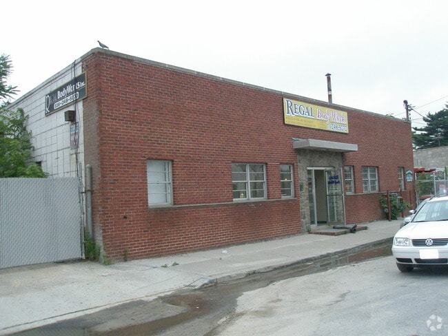
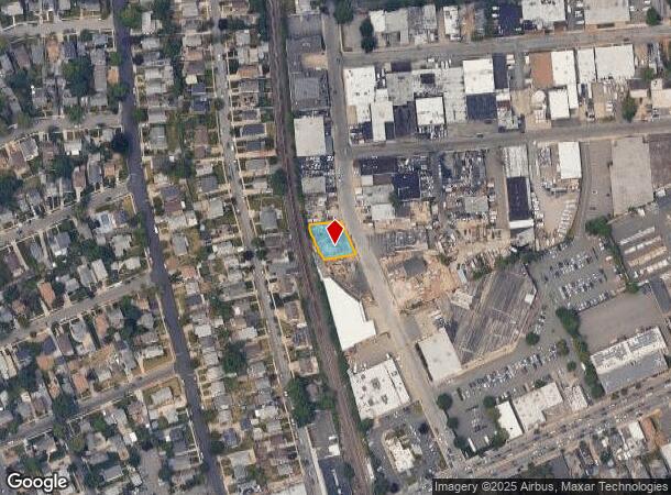
353 Sagamore Ave, Mineola, NY 11501
NEARBY LISTINGS FOR SALE OR LEASE
Property Detail
353 Sagamore Ave
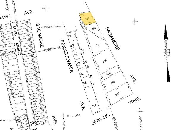
2223-09-338-00-0707-0
TOWN #2 SCH DIST 002
Autorepair
Nassau
X
New York
36059C0119G
707
2025
0.20 AC
2025
Central Nassau
303600
Long Island (New York)
4,237 SF
Nassau County-Suffolk County, NY
DEMOGRAPHICS near 353 Sagamore Ave
1 Mile
3 Mile
5 Mile
2024 Total Population
30,612
159,517
463,851
2029 Population
30,081
157,279
452,988
Pop Growth 2024-2029
(1.73%)
(1.40%)
(2.34%)
Average Age
42
42
42
2024 Total Households
11,684
53,582
146,689
HH Growth 2024-2029
(1.69%)
(1.40%)
(2.49%)
Median Household Inc
$122,098
$132,463
$120,915
Avg Household Size
2.60
2.80
3.00
2024 Avg HH Vehicles
2.00
2.00
2.00
Median Home Value
$714,316
$771,418
$713,463
Median Year Built
1951
1954
1953
Nearby Places
- Restaurants
- Banks
- Shops
- Fitness
- Groceries
PUBLIC TRANSPORTATION
TRANSIT/SUBWAY
East Williston Station (Oyster Bay Branch - Long Island Rail Road)
DRIVE
WALK
Distance
East Williston Station (Oyster Bay Branch - Long Island Rail Road)
1 min
6 min
0.3 mi
COMMUTER RAIL
East Williston Station (Oyster Bay Branch - Long Island Rail Road)
DRIVE
WALK
Distance
East Williston Station (Oyster Bay Branch - Long Island Rail Road)
1 min
10 min
0.3 mi
Mineola Station (Oyster Bay Branch - Long Island Rail Road, Port Jefferson Branch - Long Island Rail Road, Ronkonkoma Branch - Long Island Rail Road)
DRIVE
WALK
Distance
Mineola Station (Oyster Bay Branch - Long Island Rail Road, Port Jefferson Branch - Long Island Rail Road, Ronkonkoma Branch - Long Island Rail Road)
3 min
1.2 mi
AIRPORT
John F Kennedy International
DRIVE
WALK
Distance
John F Kennedy International
25 min
14.4 mi
LaGuardia
DRIVE
WALK
Distance
LaGuardia
28 min
16.2 mi
Westchester County
DRIVE
WALK
Distance
Westchester County
57 min
37.4 mi
Freight Ports
NY - Red Hook Container Terminal
DRIVE
WALK
Distance
NY - Red Hook Container Terminal
39 min
24.3 mi
Nearby Properties
Address
Land Use
TOTAL SIZE
Lot Size
Zoning
Address
Land Use
TOTAL SIZE
Lot Size
Zoning
5,322,666 SF
86.10 AC
Address
Land Use
TOTAL SIZE
Lot Size
Zoning
187,225 SF
15.35 AC
Address
Land Use
TOTAL SIZE
Lot Size
Zoning
1,188,742 SF
11.93 AC
Address
Land Use
TOTAL SIZE
Lot Size
Zoning
181,472 SF
168.80 AC
Address
Land Use
TOTAL SIZE
Lot Size
Zoning
1,197,283 SF
64.50 AC
Address
Land Use
TOTAL SIZE
Lot Size
Zoning
556,575 SF
11.46 AC
Address
Land Use
TOTAL SIZE
Lot Size
Zoning
493,535 SF
5.88 AC
Address
Land Use
TOTAL SIZE
Lot Size
Zoning
352,730 SF
41.04 AC
Address
Land Use
TOTAL SIZE
Lot Size
Zoning
29,224 SF
1.33 AC
Address
Land Use
TOTAL SIZE
Lot Size
Zoning
152,926 SF
30 AC
Address
Land Use
TOTAL SIZE
Lot Size
Zoning
277,200 SF
21.03 AC
Address
Land Use
TOTAL SIZE
Lot Size
Zoning
111,756 SF
21.24 AC
Address
Land Use
TOTAL SIZE
Lot Size
Zoning
63,600 SF
2 AC
Address
Land Use
TOTAL SIZE
Lot Size
Zoning
182,129 SF
1.51 AC
Address
Land Use
TOTAL SIZE
Lot Size
Zoning
152,783 SF
51.20 AC
Address
Land Use
TOTAL SIZE
Lot Size
Zoning
254,845 SF
22.28 AC
Address
Land Use
TOTAL SIZE
Lot Size
Zoning
399,955 SF
13.63 AC
Address
Land Use
TOTAL SIZE
Lot Size
Zoning
35,718 SF
22.15 AC
Address
Land Use
TOTAL SIZE
Lot Size
Zoning
186,050 SF
8.64 AC
Address
Land Use
TOTAL SIZE
Lot Size
Zoning
252,032 SF
4.72 AC
Address
Land Use
TOTAL SIZE
Lot Size
Zoning
147,148 SF
8.39 AC
Address
Land Use
TOTAL SIZE
Lot Size
Zoning
628,546 SF
17.53 AC
Address
Land Use
TOTAL SIZE
Lot Size
Zoning
17,292 SF
60.83 AC
Address
Land Use
TOTAL SIZE
Lot Size
Zoning
80,819 SF
6.90 AC
Address
Land Use
TOTAL SIZE
Lot Size
Zoning
31,828 SF
14.74 AC
Address
Land Use
TOTAL SIZE
Lot Size
Zoning
84,966 SF
18.74 AC
Address
Land Use
TOTAL SIZE
Lot Size
Zoning
170,753 SF
26.64 AC
Address
Land Use
TOTAL SIZE
Lot Size
Zoning
304,075 SF
14.95 AC
Address
Land Use
TOTAL SIZE
Lot Size
Zoning
197,357 SF
32.05 AC
Address
Land Use
TOTAL SIZE
Lot Size
Zoning
2,520,272 SF
36.98 AC
The World's #1 Commercial Real Estate Marketplace
Connect with us
© 2025 CoStar Group
The information above has been obtained from sources believed reliable. While we do not doubt its accuracy we have not verified it and make no guarantee, warranty or representation about it. It is your responsibility to independently confirm its accuracy and completeness. Any projections, opinions, assumptions, or estimates used are for example only and do not represent the current or future performance of the property. The value of this transaction to you depends on tax and other factors which should be evaluated by your tax, financial, and legal advisors. You and your advisors should conduct a careful, independent investigation of the property to determine to your satisfaction the suitability of the property for your needs.