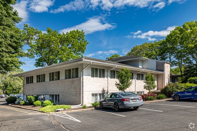
Property Record
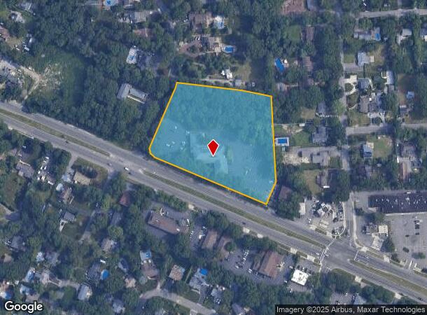
353 Vets Mem Hwy, Commack, NY 11725

Current Lease Availabilities
NEARBY LISTINGS FOR SALE OR LEASE
Property Detail
353 Vets Mem Hwy
0800-122-00-01-00-015-001
TC-57 LOTS 9,10,11, P/OWICKS FARM SEC 1 N-COSTELS-VETSMEMHWY E-OAKLAND DR
Officebuilding
Suffolk
X
New York
36103C0635H
15
2024
4.40 AC
2024
Western Suffolk
135201
Long Island (New York)
30,082 SF
Nassau County-Suffolk County, NY
DEMOGRAPHICS near 353 Vets Mem Hwy
1 Mile
3 Mile
5 Mile
2024 Total Population
8,934
70,158
216,831
2029 Population
8,854
68,911
212,013
Pop Growth 2024-2029
(0.90%)
(1.78%)
(2.22%)
Average Age
43
41
40
2024 Total Households
3,021
21,114
64,159
HH Growth 2024-2029
(1.16%)
(1.97%)
(2.39%)
Median Household Inc
$146,390
$147,146
$133,559
Avg Household Size
2.90
3.10
3.20
2024 Avg HH Vehicles
2.00
2.00
2.00
Median Home Value
$661,211
$628,068
$585,837
Median Year Built
1965
1965
1965
Nearby Places
- Restaurants
- Banks
- Shops
- Fitness
- Groceries
PUBLIC TRANSPORTATION
COMMUTER RAIL
Smithtown Station (Port Jefferson Branch - Long Island Rail Road)
DRIVE
WALK
Distance
Smithtown Station (Port Jefferson Branch - Long Island Rail Road)
10 min
4.6 mi
Kings Park Station (Port Jefferson Branch - Long Island Rail Road)
DRIVE
WALK
Distance
Kings Park Station (Port Jefferson Branch - Long Island Rail Road)
9 min
5.4 mi
AIRPORT
Long Island MacArthur
DRIVE
WALK
Distance
Long Island MacArthur
17 min
10.3 mi
LaGuardia
DRIVE
WALK
Distance
LaGuardia
56 min
38.2 mi
John F Kennedy International
DRIVE
WALK
Distance
John F Kennedy International
53 min
40.4 mi
Freight Ports
NY - Red Hook Container Terminal
DRIVE
WALK
Distance
NY - Red Hook Container Terminal
67 min
46.3 mi
Nearby Properties
Address
Land Use
TOTAL SIZE
Lot Size
Zoning
Address
Land Use
TOTAL SIZE
Lot Size
Zoning
301 SF
3.70 AC
Address
Land Use
TOTAL SIZE
Lot Size
Zoning
97.50 AC
AAA
Address
Land Use
TOTAL SIZE
Lot Size
Zoning
196.07 AC
AAA
Address
Land Use
TOTAL SIZE
Lot Size
Zoning
30.50 AC
A
Address
Land Use
TOTAL SIZE
Lot Size
Zoning
10.20 AC
B
Address
Land Use
TOTAL SIZE
Lot Size
Zoning
10.90 AC
AAA
Address
Land Use
TOTAL SIZE
Lot Size
Zoning
3.98 AC
GSE
Address
Land Use
TOTAL SIZE
Lot Size
Zoning
7.70 AC
IND1
Address
Land Use
TOTAL SIZE
Lot Size
Zoning
1.84 AC
A
Address
Land Use
TOTAL SIZE
Lot Size
Zoning
9.89 AC
IND1
Address
Land Use
TOTAL SIZE
Lot Size
Zoning
70 SF
7.99 AC
IND1
Address
Land Use
TOTAL SIZE
Lot Size
Zoning
7.10 AC
IND1
Address
Land Use
TOTAL SIZE
Lot Size
Zoning
3.01 AC
GSE
Address
Land Use
TOTAL SIZE
Lot Size
Zoning
67.94 AC
Address
Land Use
TOTAL SIZE
Lot Size
Zoning
7.10 AC
IND1
Address
Land Use
TOTAL SIZE
Lot Size
Zoning
35.70 AC
Address
Land Use
TOTAL SIZE
Lot Size
Zoning
3.81 AC
BUS2
Address
Land Use
TOTAL SIZE
Lot Size
Zoning
10 AC
IND1
Address
Land Use
TOTAL SIZE
Lot Size
Zoning
9.72 AC
AAA
Address
Land Use
TOTAL SIZE
Lot Size
Zoning
8.80 AC
IND1
Address
Land Use
TOTAL SIZE
Lot Size
Zoning
4.85 AC
GSC
Address
Land Use
TOTAL SIZE
Lot Size
Zoning
6.50 AC
IND1
Address
Land Use
TOTAL SIZE
Lot Size
Zoning
6.10 AC
IND1
Address
Land Use
TOTAL SIZE
Lot Size
Zoning
3.42 AC
AA
Address
Land Use
TOTAL SIZE
Lot Size
Zoning
4.46 AC
IND1
Address
Land Use
TOTAL SIZE
Lot Size
Zoning
4.80 AC
IND1
Address
Land Use
TOTAL SIZE
Lot Size
Zoning
4.53 AC
IND1
Address
Land Use
TOTAL SIZE
Lot Size
Zoning
3.35 AC
IND1
Address
Land Use
TOTAL SIZE
Lot Size
Zoning
5.70 AC
Address
Land Use
TOTAL SIZE
Lot Size
Zoning
4.57 AC
IND1
The World's #1 Commercial Real Estate Marketplace
Connect with us
© 2025 CoStar Group
The information above has been obtained from sources believed reliable. While we do not doubt its accuracy we have not verified it and make no guarantee, warranty or representation about it. It is your responsibility to independently confirm its accuracy and completeness. Any projections, opinions, assumptions, or estimates used are for example only and do not represent the current or future performance of the property. The value of this transaction to you depends on tax and other factors which should be evaluated by your tax, financial, and legal advisors. You and your advisors should conduct a careful, independent investigation of the property to determine to your satisfaction the suitability of the property for your needs.