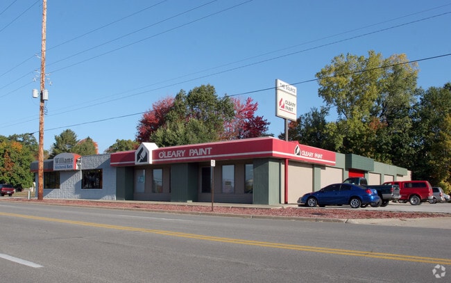
Property Record
3530 Airline Rd, Norton Shores, MI 49444

NEARBY LISTINGS FOR SALE OR LEASE
Property Detail
3530 Airline Rd
27-108-200-0008-00
CITY OF NORTON SHORES PART OF NE 1/4 DESC PART GOVT LOTS 1 & 2 SEC 8 BEG AT A PT ON A LN PAR WITH RR ROW ABUTTING SD GOVT LO
Commercialnec
Muskegon
X
Michigan
26121C0278E
1-2
2024
1.62 AC
2025
Muskegon Heights
002601
West Michigan
15,000 SF
Muskegon-Norton Shores, MI
DEMOGRAPHICS near 3530 Airline Rd
1 Mile
3 Mile
5 Mile
2024 Total Population
5,835
55,973
100,674
2029 Population
5,954
56,528
101,470
Pop Growth 2024-2029
+ 2.04%
+ 0.99%
+ 0.79%
Average Age
38
39
40
2024 Total Households
2,400
20,889
39,784
HH Growth 2024-2029
+ 2.08%
+ 0.94%
+ 0.77%
Median Household Inc
$40,833
$47,666
$49,285
Avg Household Size
2.30
2.40
2.30
2024 Avg HH Vehicles
1.00
2.00
2.00
Median Home Value
$88,874
$122,411
$139,909
Median Year Built
1959
1956
1961
Nearby Places
Map Layers
Map Styles
 Street
 Aerial
- Restaurants
- Banks
- Shops
- Fitness
- Groceries
SALE & LEASE HISTORY
LISTING DATE
SALE/LEASE

Sep 27, 2023
For Lease
May 22, 2017
For Lease
May 22, 2017
For Sale
Jul 28, 2022
For Sale
Jul 07, 2022
For Lease
Nearby Properties
Address
Land Use
TOTAL SIZE
Lot Size
Zoning
Address
Land Use
TOTAL SIZE
Lot Size
Zoning
490,693 SF
22.70 AC
Address
Land Use
TOTAL SIZE
Lot Size
Zoning
82,643 SF
5.20 AC
MC
Address
Land Use
TOTAL SIZE
Lot Size
Zoning
350,077 SF
41.42 AC
PUD
Address
Land Use
TOTAL SIZE
Lot Size
Zoning
249,032 SF
19.18 AC
MFR
Address
Land Use
TOTAL SIZE
Lot Size
Zoning
223,802 SF
22.02 AC
SC-1
Address
Land Use
TOTAL SIZE
Lot Size
Zoning
237,612 SF
13.40 AC
PUD
Address
Land Use
TOTAL SIZE
Lot Size
Zoning
41,382 SF
6.20 AC
PUD
Address
Land Use
TOTAL SIZE
Lot Size
Zoning
271,435 SF
13.80 AC
I-2
Address
Land Use
TOTAL SIZE
Lot Size
Zoning
219,341 SF
18.55 AC
C-SE
Address
Land Use
TOTAL SIZE
Lot Size
Zoning
80,572 SF
12.98 AC
I-1
Address
Land Use
TOTAL SIZE
Lot Size
Zoning
194,708 SF
15.59 AC
C-2
Address
Land Use
TOTAL SIZE
Lot Size
Zoning
19,171 SF
6.55 AC
MC
Address
Land Use
TOTAL SIZE
Lot Size
Zoning
149,707 SF
35.72 AC
GI
Address
Land Use
TOTAL SIZE
Lot Size
Zoning
91,682 SF
21.93 AC
PUD
Address
Land Use
TOTAL SIZE
Lot Size
Zoning
350,378 SF
21.50 AC
GI
Address
Land Use
TOTAL SIZE
Lot Size
Zoning
71,329 SF
I-2
Address
Land Use
TOTAL SIZE
Lot Size
Zoning
184,786 SF
24.10 AC
SUD
Address
Land Use
TOTAL SIZE
Lot Size
Zoning
125,059 SF
10.47 AC
PUD
Address
Land Use
TOTAL SIZE
Lot Size
Zoning
82,895 SF
13.09 AC
SC-1
Address
Land Use
TOTAL SIZE
Lot Size
Zoning
85,577 SF
8.72 AC
PUD
Address
Land Use
TOTAL SIZE
Lot Size
Zoning
215,706 SF
23.21 AC
PUD
Address
Land Use
TOTAL SIZE
Lot Size
Zoning
50,252 SF
6.94 AC
C-2
Address
Land Use
TOTAL SIZE
Lot Size
Zoning
65,204 SF
2.43 AC
PUD
Address
Land Use
TOTAL SIZE
Lot Size
Zoning
241,589 SF
14.60 AC
I-2
Address
Land Use
TOTAL SIZE
Lot Size
Zoning
68,782 SF
10.52 AC
C-2
Address
Land Use
TOTAL SIZE
Lot Size
Zoning
121,466 SF
11.65 AC
SC-1
Address
Land Use
TOTAL SIZE
Lot Size
Zoning
143,193 SF
13.82 AC
SC-1
Address
Land Use
TOTAL SIZE
Lot Size
Zoning
122.75 AC
R-2
Address
Land Use
TOTAL SIZE
Lot Size
Zoning
124,416 SF
7.41 AC
MFR
Address
Land Use
TOTAL SIZE
Lot Size
Zoning
60,658 SF
4.42 AC
RM-2
The World's #1 Commercial Real Estate Marketplace
Connect with us
© 2026 CoStar Group
The information above has been obtained from sources believed reliable. While we do not doubt its accuracy we have not verified it and make no guarantee, warranty or representation about it. It is your responsibility to independently confirm its accuracy and completeness. Any projections, opinions, assumptions, or estimates used are for example only and do not represent the current or future performance of the property. The value of this transaction to you depends on tax and other factors which should be evaluated by your tax, financial, and legal advisors. You and your advisors should conduct a careful, independent investigation of the property to determine to your satisfaction the suitability of the property for your needs.