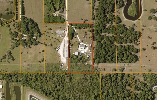
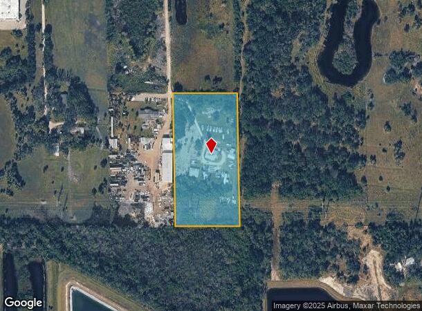
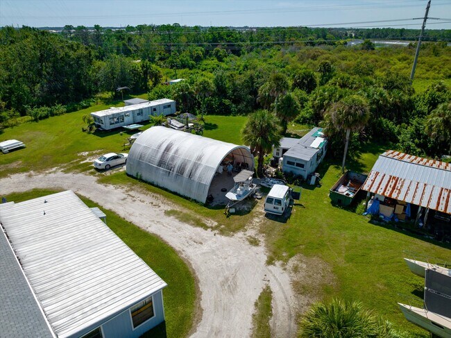
Property Record
3530 Laurel Rd E, North Venice, FL 34275
NEARBY LISTINGS FOR SALE OR LEASE
Property Detail
3530 Laurel Rd E
North Port-Bradenton-Sarasota, FL
Not Part Of A Subdivision
0389-00-2009
COM NW COR SEC 34 TH S-89-34-05- E 1039.82 FT TH S-1-03-08-E 669.9 FT FOR POB TH S-89-38-03-E 325.31 FT TH S-1-03-08-E 669.52 FT TH N-89-42-W 325.3 FT TH N-1- 03-08-W 669.89 FT TO POB
Multifamilydwelling
Sarasota
AE
Florida
12115C0244G
4
2024
5 AC
2025
Sarasota Outlying
002726
Tampa/St Petersburg
1,804 SF
DEMOGRAPHICS near 3530 Laurel Rd E
1 Mile
3 Mile
5 Mile
2024 Total Population
2,278
31,066
78,496
2029 Population
2,727
36,456
91,787
Pop Growth 2024-2029
+ 19.71%
+ 17.35%
+ 16.93%
Average Age
62
60
59
2024 Total Households
1,141
15,726
40,017
HH Growth 2024-2029
+ 19.54%
+ 17.27%
+ 16.99%
Median Household Inc
$94,066
$72,695
$70,922
Avg Household Size
2.00
1.90
1.90
2024 Avg HH Vehicles
2.00
2.00
2.00
Median Home Value
$394,397
$345,416
$342,264
Median Year Built
2010
1997
1987
Nearby Places
Map Layers
Map Styles
 Street
 Aerial
- Restaurants
- Banks
- Shops
- Fitness
- Groceries
PUBLIC TRANSPORTATION
AIRPORT
Sarasota/Bradenton International
DRIVE
WALK
Distance
Sarasota/Bradenton International
38 min
26.9 mi
Punta Gorda
DRIVE
WALK
Distance
Punta Gorda
45 min
36.3 mi
Freight Ports
Port Manatee
DRIVE
WALK
Distance
Port Manatee
50 min
39.4 mi
SALE & LEASE HISTORY
LISTING DATE
SALE/LEASE

Sep 26, 2023
For Sale
Sep 24, 2016
For Sale
Sep 13, 2017
For Sale
Nov 13, 2020
For Sale
Dec 05, 2019
For Sale
Nearby Properties
Address
Land Use
TOTAL SIZE
Lot Size
Zoning
Address
Land Use
TOTAL SIZE
Lot Size
Zoning
738,835 SF
65.43 AC
LW
Address
Land Use
TOTAL SIZE
Lot Size
Zoning
26,265 SF
210.50 AC
RMH
Address
Land Use
TOTAL SIZE
Lot Size
Zoning
333,296 SF
16.80 AC
RMF3
Address
Land Use
TOTAL SIZE
Lot Size
Zoning
432,671 SF
48.53 AC
RMF2
Address
Land Use
TOTAL SIZE
Lot Size
Zoning
421,272 SF
31.96 AC
PUD
Address
Land Use
TOTAL SIZE
Lot Size
Zoning
308,834 SF
16 AC
PUD
Address
Land Use
TOTAL SIZE
Lot Size
Zoning
273,036 SF
28.76 AC
RMF3
Address
Land Use
TOTAL SIZE
Lot Size
Zoning
238,850 SF
18.24 AC
LE
Address
Land Use
TOTAL SIZE
Lot Size
Zoning
263,056 SF
25.54 AC
LW
Address
Land Use
TOTAL SIZE
Lot Size
Zoning
181,657 SF
56.90 AC
GU
Address
Land Use
TOTAL SIZE
Lot Size
Zoning
23,348 SF
77.03 AC
RMH
Address
Land Use
TOTAL SIZE
Lot Size
Zoning
48,681 SF
5 AC
OPI
Address
Land Use
TOTAL SIZE
Lot Size
Zoning
177,646 SF
5.23 AC
LE
Address
Land Use
TOTAL SIZE
Lot Size
Zoning
362,000 SF
41.51 AC
PID
Address
Land Use
TOTAL SIZE
Lot Size
Zoning
1,184 SF
90 AC
PUD
Address
Land Use
TOTAL SIZE
Lot Size
Zoning
183,584 SF
14.54 AC
PUD
Address
Land Use
TOTAL SIZE
Lot Size
Zoning
252,213 SF
13.49 AC
LE
Address
Land Use
TOTAL SIZE
Lot Size
Zoning
5,396 SF
33.59 AC
RMH
Address
Land Use
TOTAL SIZE
Lot Size
Zoning
81,883 SF
11.90 AC
CSC
Address
Land Use
TOTAL SIZE
Lot Size
Zoning
115,360 SF
14.60 AC
ILW
Address
Land Use
TOTAL SIZE
Lot Size
Zoning
63,549 SF
6.26 AC
OPI
Address
Land Use
TOTAL SIZE
Lot Size
Zoning
101,219 SF
4.90 AC
OPI
Address
Land Use
TOTAL SIZE
Lot Size
Zoning
76,247 SF
13.89 AC
CG
Address
Land Use
TOTAL SIZE
Lot Size
Zoning
110,209 SF
12.55 AC
PID
Address
Land Use
TOTAL SIZE
Lot Size
Zoning
70,220 SF
9.31 AC
LW
Address
Land Use
TOTAL SIZE
Lot Size
Zoning
125,001 SF
3.13 AC
CG
Address
Land Use
TOTAL SIZE
Lot Size
Zoning
8,040 SF
46.23 AC
RMH
Address
Land Use
TOTAL SIZE
Lot Size
Zoning
115,474 SF
12.08 AC
PID
Address
Land Use
TOTAL SIZE
Lot Size
Zoning
49,400 SF
4.51 AC
OPI
Address
Land Use
TOTAL SIZE
Lot Size
Zoning
120,522 SF
5.25 AC
PID
The World's #1 Commercial Real Estate Marketplace
Connect with us
© 2026 CoStar Group
The information above has been obtained from sources believed reliable. While we do not doubt its accuracy we have not verified it and make no guarantee, warranty or representation about it. It is your responsibility to independently confirm its accuracy and completeness. Any projections, opinions, assumptions, or estimates used are for example only and do not represent the current or future performance of the property. The value of this transaction to you depends on tax and other factors which should be evaluated by your tax, financial, and legal advisors. You and your advisors should conduct a careful, independent investigation of the property to determine to your satisfaction the suitability of the property for your needs.