Property Record
3530 State Route 27, Kendall Park, NJ 08824
Current Lease Availabilities
NEARBY LISTINGS FOR SALE OR LEASE
Property Detail
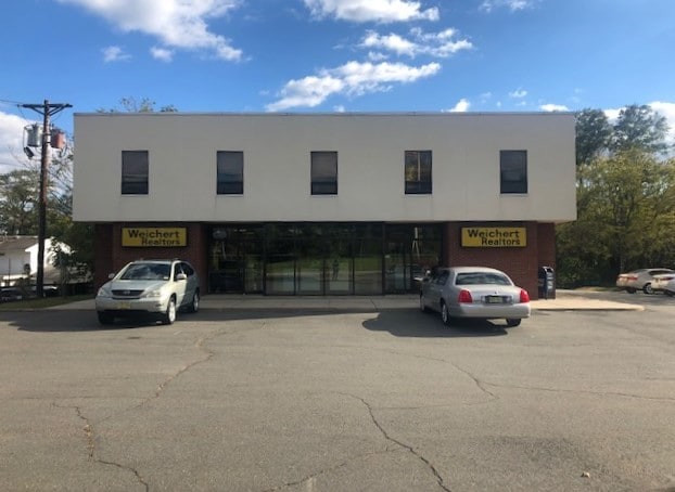
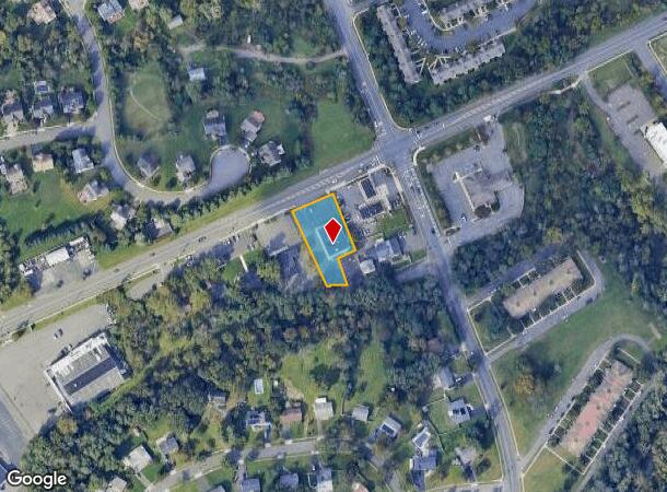
3530 State Route 27
Lakewood-New Brunswick, NJ
0.607 AC. 9,300 SF OFFICE BLDG
21-00348-0000-00024-04
Middlesex
Officebuilding
New Jersey
X
24.4
34023C0112F
0.61 AC
2024
Brunswick West
2025
Northern New Jersey
008505
DEMOGRAPHICS near 3530 State Route 27
1 Mile
3 Mile
5 Mile
2024 Total Population
9,335
46,521
113,062
2029 Population
9,303
46,409
112,860
Pop Growth 2024-2029
(0.34%)
(0.24%)
(0.18%)
Average Age
42
40
40
2024 Total Households
3,254
16,721
39,233
HH Growth 2024-2029
(0.46%)
(0.31%)
(0.27%)
Median Household Inc
$150,295
$121,912
$135,657
Avg Household Size
2.80
2.80
2.80
2024 Avg HH Vehicles
2.00
2.00
2.00
Median Home Value
$486,484
$490,701
$510,344
Median Year Built
1985
1987
1988
Nearby Places
Map Layers
Map Styles
 Street
 Aerial
- Restaurants
- Banks
- Shops
- Fitness
- Groceries
PUBLIC TRANSPORTATION
COMMUTER RAIL
Jersey Avenue (Northeast Corridor Line - NJ Transit Commuter Rail (NJ Transit))
DRIVE
WALK
Distance
Jersey Avenue (Northeast Corridor Line - NJ Transit Commuter Rail (NJ Transit))
11 min
6.0 mi
Princeton (Princeton Branch - NJ Transit Commuter Rail (NJ Transit))
DRIVE
WALK
Distance
Princeton (Princeton Branch - NJ Transit Commuter Rail (NJ Transit))
19 min
9.5 mi
AIRPORT
Newark Liberty International
DRIVE
WALK
Distance
Newark Liberty International
37 min
30.8 mi
Nearby Properties
Address
Land Use
TOTAL SIZE
Lot Size
Zoning
Address
Land Use
TOTAL SIZE
Lot Size
Zoning
2,530 SF
20.05 AC
R10B
Address
Land Use
TOTAL SIZE
Lot Size
Zoning
34.75 AC
CR
Address
Land Use
TOTAL SIZE
Lot Size
Zoning
419,094 SF
49.17 AC
CR
Address
Land Use
TOTAL SIZE
Lot Size
Zoning
141,554 SF
15 AC
NB
Address
Land Use
TOTAL SIZE
Lot Size
Zoning
2,676 SF
16.50 AC
CR
Address
Land Use
TOTAL SIZE
Lot Size
Zoning
95,064 SF
14.41 AC
CR
Address
Land Use
TOTAL SIZE
Lot Size
Zoning
192,072 SF
19.83 AC
CR
Address
Land Use
TOTAL SIZE
Lot Size
Zoning
97,470 SF
11 AC
NB
Address
Land Use
TOTAL SIZE
Lot Size
Zoning
28.96 AC
R10B
Address
Land Use
TOTAL SIZE
Lot Size
Zoning
27.47 AC
R5
Address
Land Use
TOTAL SIZE
Lot Size
Zoning
6.36 AC
R10B
Address
Land Use
TOTAL SIZE
Lot Size
Zoning
Address
Land Use
TOTAL SIZE
Lot Size
Zoning
72,720 SF
8.99 AC
NB
Address
Land Use
TOTAL SIZE
Lot Size
Zoning
14.19 AC
CRM3
Address
Land Use
TOTAL SIZE
Lot Size
Zoning
152.47 AC
PL
Address
Land Use
TOTAL SIZE
Lot Size
Zoning
7.45 AC
R10B
Address
Land Use
TOTAL SIZE
Lot Size
Zoning
14.71 AC
C-2
Address
Land Use
TOTAL SIZE
Lot Size
Zoning
14.63 AC
RM-3
Address
Land Use
TOTAL SIZE
Lot Size
Zoning
13.81 AC
PL
Address
Land Use
TOTAL SIZE
Lot Size
Zoning
90.49 AC
PL
Address
Land Use
TOTAL SIZE
Lot Size
Zoning
18.51 AC
Address
Land Use
TOTAL SIZE
Lot Size
Zoning
3.97 AC
NB
Address
Land Use
TOTAL SIZE
Lot Size
Zoning
45.20 AC
C-2
Address
Land Use
TOTAL SIZE
Lot Size
Zoning
17.75 AC
MF
Address
Land Use
TOTAL SIZE
Lot Size
Zoning
12 AC
PL
Address
Land Use
TOTAL SIZE
Lot Size
Zoning
11.32 AC
C2R3
Address
Land Use
TOTAL SIZE
Lot Size
Zoning
8.01 AC
PL
Address
Land Use
TOTAL SIZE
Lot Size
Zoning
80,705 SF
11.85 AC
C-2
Address
Land Use
TOTAL SIZE
Lot Size
Zoning
22,822 SF
3.33 AC
NBH
Address
Land Use
TOTAL SIZE
Lot Size
Zoning
1,058 SF
1.45 AC
C3
The World's #1 Commercial Real Estate Marketplace
Connect with us
© 2026 CoStar Group
The information above has been obtained from sources believed reliable. While we do not doubt its accuracy we have not verified it and make no guarantee, warranty or representation about it. It is your responsibility to independently confirm its accuracy and completeness. Any projections, opinions, assumptions, or estimates used are for example only and do not represent the current or future performance of the property. The value of this transaction to you depends on tax and other factors which should be evaluated by your tax, financial, and legal advisors. You and your advisors should conduct a careful, independent investigation of the property to determine to your satisfaction the suitability of the property for your needs.