Property Record
3531 E Monte Vista Ave, Denair, CA 95316
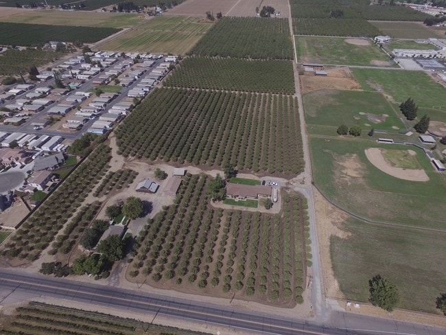


Property Detail
3531 E Monte Vista Ave
024-12-09
Stanislaus
Residentialacreage
California
B and X Area of moderate flood hazard, usually the area between the limits of the 100-year and 500-year floods.
27
2025
18.61 AC
2025
Hughson/Oakdale/Waterford
003608
Stockton/Modesto
3,682 SF
Modesto, CA
NEARBY LISTINGS FOR SALE OR LEASE
DEMOGRAPHICS near 3531 E Monte Vista Ave
1 mile
3 mile
5 mile
2025 Total Population
5,565
52,528
88,016
2030 Population
5,627
53,379
89,094
Pop Growth 2025-2030
+ 1.11%
+ 1.62%
+ 1.22%
Average Age
39
39
38
2025 Total Households
1,840
18,362
29,264
HH Growth 2025-2030
+ 1.14%
+ 1.78%
+ 1.33%
Median Household Inc
$116,342
$88,442
$86,596
Avg Household Size
3.00
2.70
2.90
2025 Avg HH Vehicles
2.00
2.00
2.00
Median Home Value
$601,535
$500,102
$477,957
Median Year Built
1988
1979
1983
Nearby Places
Map Layers
Map Styles
 Street
 Aerial
Layers
 Traffic
 Biking
Places
Listings with unknown addresses are not visible on the map
- Restaurants
- Banks
- Shops
- Fitness
- Groceries
SALE & LEASE HISTORY
LISTING DATE
SALE/LEASE

Oct 08, 2018
For Sale
Nearby Properties
Address
Land Use
TOTAL SIZE
Lot Size
Zoning
Address
Land Use
TOTAL SIZE
Lot Size
Zoning
281,904 SF
17.84 AC
Address
Land Use
TOTAL SIZE
Lot Size
Zoning
264,573 SF
9.47 AC
TURPD
Address
Land Use
TOTAL SIZE
Lot Size
Zoning
144,510 SF
12.04 AC
Address
Land Use
TOTAL SIZE
Lot Size
Zoning
111,617 SF
10.10 AC
Address
Land Use
TOTAL SIZE
Lot Size
Zoning
149,310 SF
8.45 AC
Address
Land Use
TOTAL SIZE
Lot Size
Zoning
184,158 SF
9.08 AC
PD21
Address
Land Use
TOTAL SIZE
Lot Size
Zoning
302,449 SF
17.57 AC
Address
Land Use
TOTAL SIZE
Lot Size
Zoning
103,011 SF
7.90 AC
Address
Land Use
TOTAL SIZE
Lot Size
Zoning
68,015 SF
4.45 AC
CO
Address
Land Use
TOTAL SIZE
Lot Size
Zoning
55,955 SF
3.76 AC
TURRL
Address
Land Use
TOTAL SIZE
Lot Size
Zoning
44,860 SF
2.93 AC
Address
Land Use
TOTAL SIZE
Lot Size
Zoning
120,762 SF
9.39 AC
Address
Land Use
TOTAL SIZE
Lot Size
Zoning
110,184 SF
6.60 AC
Address
Land Use
TOTAL SIZE
Lot Size
Zoning
114,240 SF
6.06 AC
Address
Land Use
TOTAL SIZE
Lot Size
Zoning
100,911 SF
14.88 AC
Address
Land Use
TOTAL SIZE
Lot Size
Zoning
49,250 SF
2.77 AC
Address
Land Use
TOTAL SIZE
Lot Size
Zoning
42,096 SF
3.17 AC
Address
Land Use
TOTAL SIZE
Lot Size
Zoning
57,674 SF
4 AC
Address
Land Use
TOTAL SIZE
Lot Size
Zoning
48,612 SF
2.53 AC
Address
Land Use
TOTAL SIZE
Lot Size
Zoning
93,448 SF
4.77 AC
Address
Land Use
TOTAL SIZE
Lot Size
Zoning
73,540 SF
3.83 AC
Address
Land Use
TOTAL SIZE
Lot Size
Zoning
177,727 SF
9.14 AC
Address
Land Use
TOTAL SIZE
Lot Size
Zoning
93,664 SF
4.57 AC
Address
Land Use
TOTAL SIZE
Lot Size
Zoning
38,600 SF
3.29 AC
Address
Land Use
TOTAL SIZE
Lot Size
Zoning
34,156 SF
6.25 AC
Address
Land Use
TOTAL SIZE
Lot Size
Zoning
19,727 SF
2.06 AC
TURCC
Address
Land Use
TOTAL SIZE
Lot Size
Zoning
28,888 SF
2.07 AC
Address
Land Use
TOTAL SIZE
Lot Size
Zoning
21,480 SF
1.53 AC
Address
Land Use
TOTAL SIZE
Lot Size
Zoning
32,500 SF
2.31 AC
Address
Land Use
TOTAL SIZE
Lot Size
Zoning
7,240 SF
101.54 AC
A240
The World's #1 Commercial Real Estate Marketplace
Connect with us
© 2026 CoStar Group
The information above has been obtained from sources believed reliable. While we do not doubt its accuracy we have not verified it and make no guarantee, warranty or representation about it. It is your responsibility to independently confirm its accuracy and completeness. Any projections, opinions, assumptions, or estimates used are for example only and do not represent the current or future performance of the property. The value of this transaction to you depends on tax and other factors which should be evaluated by your tax, financial, and legal advisors. You and your advisors should conduct a careful, independent investigation of the property to determine to your satisfaction the suitability of the property for your needs.