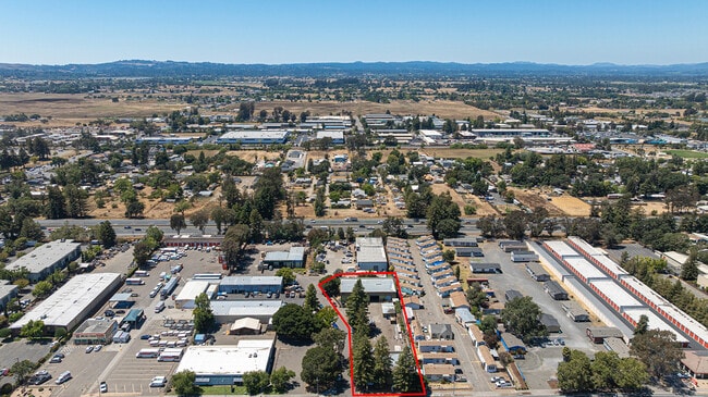
Property Record
3529 Santa Rosa Ave, Santa Rosa, CA 95407


Current Lease Availabilities
NEARBY LISTINGS FOR SALE OR LEASE
Property Detail
3529 Santa Rosa Ave
134-123-031
76 FM 134-123-27 & PT RD OR 2997-853 PM4478 PCL 2
Commercialnec
Sonoma
X
California
06097C0739F
2
2024
1 AC
2025
Santa Rosa
153201
North Bay/Santa Rosa
9,300 SF
Santa Rosa, CA
DEMOGRAPHICS near 3529 Santa Rosa Ave
1 Mile
3 Mile
5 Mile
2024 Total Population
7,198
63,549
187,864
2029 Population
7,052
62,806
185,711
Pop Growth 2024-2029
(2.03%)
(1.17%)
(1.15%)
Average Age
35
38
40
2024 Total Households
2,204
20,680
68,737
HH Growth 2024-2029
(2.22%)
(1.18%)
(1.18%)
Median Household Inc
$58,414
$80,829
$86,561
Avg Household Size
3.10
2.90
2.60
2024 Avg HH Vehicles
2.00
2.00
2.00
Median Home Value
$451,388
$647,961
$690,460
Median Year Built
1986
1985
1978
Nearby Places
Map Layers
Map Styles
 Street
 Aerial
- Restaurants
- Banks
- Shops
- Fitness
- Groceries
PUBLIC TRANSPORTATION
COMMUTER RAIL
Rohnert Park Smart (Main Line - Sonoma Marin Area Rail Transit)
DRIVE
WALK
Distance
Rohnert Park Smart (Main Line - Sonoma Marin Area Rail Transit)
7 min
4.2 mi
Santa Rosa Downtown Smart (Main Line - Sonoma Marin Area Rail Transit)
DRIVE
WALK
Distance
Santa Rosa Downtown Smart (Main Line - Sonoma Marin Area Rail Transit)
6 min
4.2 mi
AIRPORT
Charles M Schulz - Sonoma County
DRIVE
WALK
Distance
Charles M Schulz - Sonoma County
17 min
11.9 mi
Freight Ports
Port of Richmond
DRIVE
WALK
Distance
Port of Richmond
59 min
45.3 mi
Nearby Properties
Address
Land Use
TOTAL SIZE
Lot Size
Zoning
Address
Land Use
TOTAL SIZE
Lot Size
Zoning
285,160 SF
8.23 AC
Address
Land Use
TOTAL SIZE
Lot Size
Zoning
295,383 SF
12.30 AC
Address
Land Use
TOTAL SIZE
Lot Size
Zoning
249,210 SF
22.98 AC
C-2
Address
Land Use
TOTAL SIZE
Lot Size
Zoning
92,480 SF
33.80 AC
Address
Land Use
TOTAL SIZE
Lot Size
Zoning
287,036 SF
11.09 AC
MLPD
Address
Land Use
TOTAL SIZE
Lot Size
Zoning
203,119 SF
9.35 AC
Address
Land Use
TOTAL SIZE
Lot Size
Zoning
123,512 SF
15.83 AC
CITYRP
Address
Land Use
TOTAL SIZE
Lot Size
Zoning
184,186 SF
6 AC
MLPD
Address
Land Use
TOTAL SIZE
Lot Size
Zoning
142,297 SF
4.65 AC
Address
Land Use
TOTAL SIZE
Lot Size
Zoning
10.30 AC
Address
Land Use
TOTAL SIZE
Lot Size
Zoning
105,696 SF
5.46 AC
Address
Land Use
TOTAL SIZE
Lot Size
Zoning
187,024 SF
8.64 AC
Address
Land Use
TOTAL SIZE
Lot Size
Zoning
180,934 SF
5.55 AC
CITYRP
Address
Land Use
TOTAL SIZE
Lot Size
Zoning
87,300 SF
6.64 AC
Address
Land Use
TOTAL SIZE
Lot Size
Zoning
87,750 SF
5.43 AC
Address
Land Use
TOTAL SIZE
Lot Size
Zoning
82,215 SF
7.91 AC
C2
Address
Land Use
TOTAL SIZE
Lot Size
Zoning
7,370 SF
4.85 AC
M3
Address
Land Use
TOTAL SIZE
Lot Size
Zoning
213,331 SF
12.53 AC
CREC
Address
Land Use
TOTAL SIZE
Lot Size
Zoning
165,408 SF
5.40 AC
MLPD
Address
Land Use
TOTAL SIZE
Lot Size
Zoning
149,007 SF
0.25 AC
M1RP
Address
Land Use
TOTAL SIZE
Lot Size
Zoning
49,077 SF
7.09 AC
R210
Address
Land Use
TOTAL SIZE
Lot Size
Zoning
61,880 SF
2.53 AC
Address
Land Use
TOTAL SIZE
Lot Size
Zoning
107,599 SF
2.98 AC
Address
Land Use
TOTAL SIZE
Lot Size
Zoning
67,584 SF
4.79 AC
CITYRP
Address
Land Use
TOTAL SIZE
Lot Size
Zoning
111,261 SF
7.37 AC
C4
Address
Land Use
TOTAL SIZE
Lot Size
Zoning
142,272 SF
0.25 AC
C2
Address
Land Use
TOTAL SIZE
Lot Size
Zoning
95,238 SF
4.96 AC
CITYSR
Address
Land Use
TOTAL SIZE
Lot Size
Zoning
3.33 AC
MLPD
Address
Land Use
TOTAL SIZE
Lot Size
Zoning
77,660 SF
2.09 AC
CITYRP
Address
Land Use
TOTAL SIZE
Lot Size
Zoning
3,720 SF
4.11 AC
C2
The World's #1 Commercial Real Estate Marketplace
Connect with us
© 2025 CoStar Group
The information above has been obtained from sources believed reliable. While we do not doubt its accuracy we have not verified it and make no guarantee, warranty or representation about it. It is your responsibility to independently confirm its accuracy and completeness. Any projections, opinions, assumptions, or estimates used are for example only and do not represent the current or future performance of the property. The value of this transaction to you depends on tax and other factors which should be evaluated by your tax, financial, and legal advisors. You and your advisors should conduct a careful, independent investigation of the property to determine to your satisfaction the suitability of the property for your needs.