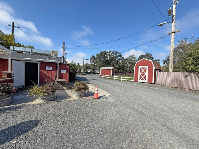
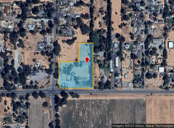
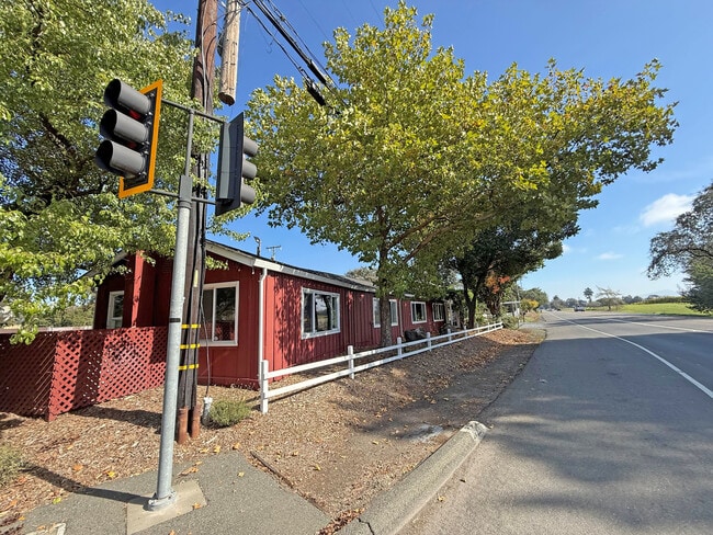
Property Record
3555 Guerneville Rd, Santa Rosa, CA 95401
Current Lease Availabilities
NEARBY LISTINGS FOR SALE OR LEASE
Property Detail
3555 Guerneville Rd
034-072-049
Lyttaker Tract
Commercialbuilding
Sonoma
X
California
06097C0708E
3.11 AC
2024
Santa Rosa
2025
North Bay/Santa Rosa
152906
Santa Rosa, CA
5,660 SF
DEMOGRAPHICS near 3555 Guerneville Rd
1 Mile
3 Mile
5 Mile
2024 Total Population
821
26,204
120,785
2029 Population
796
25,942
120,549
Pop Growth 2024-2029
(3.05%)
(1.00%)
(0.20%)
Average Age
46
43
41
2024 Total Households
316
9,494
43,476
HH Growth 2024-2029
(3.16%)
(1.12%)
(0.26%)
Median Household Inc
$108,881
$115,438
$96,296
Avg Household Size
2.60
2.70
2.70
2024 Avg HH Vehicles
2.00
2.00
2.00
Median Home Value
$780,612
$745,135
$729,907
Median Year Built
1978
1982
1980
Nearby Places
Map Layers
Map Styles
 Street
 Aerial
- Restaurants
- Banks
- Shops
- Fitness
- Groceries
PUBLIC TRANSPORTATION
COMMUTER RAIL
Santa Rosa North Smart (Main Line - Sonoma Marin Area Rail Transit)
DRIVE
WALK
Distance
Santa Rosa North Smart (Main Line - Sonoma Marin Area Rail Transit)
8 min
4.1 mi
Sonoma County Airport Smart (Main Line - Sonoma Marin Area Rail Transit)
DRIVE
WALK
Distance
Sonoma County Airport Smart (Main Line - Sonoma Marin Area Rail Transit)
14 min
7.2 mi
AIRPORT
Charles M Schulz - Sonoma County
DRIVE
WALK
Distance
Charles M Schulz - Sonoma County
16 min
8.1 mi
Freight Ports
Port of Richmond
DRIVE
WALK
Distance
Port of Richmond
72 min
53.8 mi
Nearby Properties
Address
Land Use
TOTAL SIZE
Lot Size
Zoning
Address
Land Use
TOTAL SIZE
Lot Size
Zoning
71,800 SF
7.76 AC
CIPD
Address
Land Use
TOTAL SIZE
Lot Size
Zoning
Address
Land Use
TOTAL SIZE
Lot Size
Zoning
11,827 SF
19.16 AC
DA20
Address
Land Use
TOTAL SIZE
Lot Size
Zoning
Address
Land Use
TOTAL SIZE
Lot Size
Zoning
71,564 SF
5.74 AC
CITYSR
Address
Land Use
TOTAL SIZE
Lot Size
Zoning
26,734 SF
9.55 AC
Address
Land Use
TOTAL SIZE
Lot Size
Zoning
64,235 SF
5.61 AC
CITYSR
Address
Land Use
TOTAL SIZE
Lot Size
Zoning
53,599 SF
3.51 AC
Address
Land Use
TOTAL SIZE
Lot Size
Zoning
44,861 SF
3.76 AC
CITYSR
Address
Land Use
TOTAL SIZE
Lot Size
Zoning
22,493 SF
40.24 AC
Address
Land Use
TOTAL SIZE
Lot Size
Zoning
2,029 SF
121.99 AC
Address
Land Use
TOTAL SIZE
Lot Size
Zoning
21,971 SF
9 AC
Address
Land Use
TOTAL SIZE
Lot Size
Zoning
50,552 SF
2.87 AC
CITYSR
Address
Land Use
TOTAL SIZE
Lot Size
Zoning
13,800 SF
12.17 AC
LIA40
Address
Land Use
TOTAL SIZE
Lot Size
Zoning
53,766 SF
20 AC
Address
Land Use
TOTAL SIZE
Lot Size
Zoning
5.10 AC
CITYSR
Address
Land Use
TOTAL SIZE
Lot Size
Zoning
9,127 SF
262.94 AC
LEAB7FRZN
Address
Land Use
TOTAL SIZE
Lot Size
Zoning
108.93 AC
LIA40
Address
Land Use
TOTAL SIZE
Lot Size
Zoning
25,036 SF
2.03 AC
PC
Address
Land Use
TOTAL SIZE
Lot Size
Zoning
46,649 SF
9.09 AC
AR5
Address
Land Use
TOTAL SIZE
Lot Size
Zoning
29,861 SF
4 AC
Address
Land Use
TOTAL SIZE
Lot Size
Zoning
119.63 AC
LIA40
Address
Land Use
TOTAL SIZE
Lot Size
Zoning
18.05 AC
DA40
Address
Land Use
TOTAL SIZE
Lot Size
Zoning
45,172 SF
93.59 AC
Address
Land Use
TOTAL SIZE
Lot Size
Zoning
36,913 SF
0.79 AC
Address
Land Use
TOTAL SIZE
Lot Size
Zoning
22,954 SF
69.97 AC
LEA60
Address
Land Use
TOTAL SIZE
Lot Size
Zoning
1,500 SF
69 AC
LIA40
Address
Land Use
TOTAL SIZE
Lot Size
Zoning
43,968 SF
9.67 AC
Address
Land Use
TOTAL SIZE
Lot Size
Zoning
32,656 SF
0.72 AC
CITYSR
Address
Land Use
TOTAL SIZE
Lot Size
Zoning
6,260 SF
0.14 AC
LIA40
The World's #1 Commercial Real Estate Marketplace
Connect with us
© 2025 CoStar Group
The information above has been obtained from sources believed reliable. While we do not doubt its accuracy we have not verified it and make no guarantee, warranty or representation about it. It is your responsibility to independently confirm its accuracy and completeness. Any projections, opinions, assumptions, or estimates used are for example only and do not represent the current or future performance of the property. The value of this transaction to you depends on tax and other factors which should be evaluated by your tax, financial, and legal advisors. You and your advisors should conduct a careful, independent investigation of the property to determine to your satisfaction the suitability of the property for your needs.