Property Record
3535 Interstate 55, Marion, AR 72364
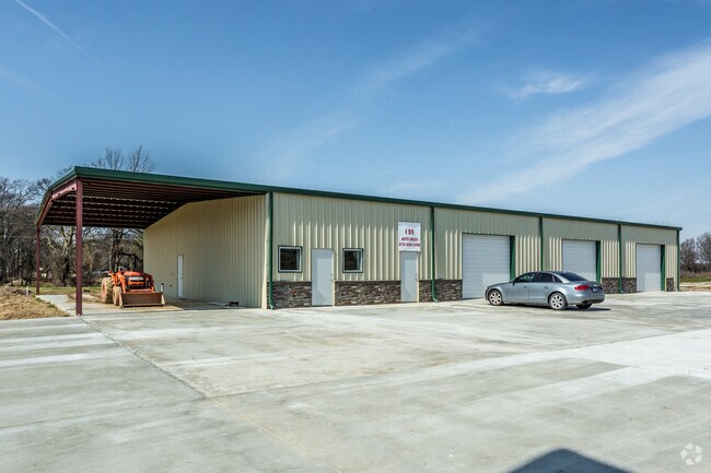


Property Detail
3535 Interstate 55
236-164100-000
NE1/4 E OF D W OF HWY 61 N OF HWY 64,IN SP GR 2325 LESS 1 ACRE IN SE COR. UNRECORDED PLAT ON FILE
Officebuilding
CRITTENDEN
C and X Area of minimal flood hazard, usually depicted on FIRMs as above the 500-year flood level.
Arkansas
2025
3.50 AC
2025
Crittenden County
030805
Memphis
6,000 SF
Memphis, TN-MS-AR
NEARBY LISTINGS FOR SALE OR LEASE
DEMOGRAPHICS near 3535 Interstate 55
1 mile
3 mile
5 mile
2025 Total Population
4,086
13,984
26,531
2030 Population
3,940
13,541
25,644
Pop Growth 2025-2030
(3.57%)
(3.17%)
(3.34%)
Average Age
38
38
39
2025 Total Households
1,561
5,202
10,161
HH Growth 2025-2030
(3.91%)
(3.27%)
(3.44%)
Median Household Inc
$61,574
$71,741
$64,923
Avg Household Size
2.50
2.60
2.50
2025 Avg HH Vehicles
2.00
2.00
2.00
Median Home Value
$189,837
$218,722
$190,776
Median Year Built
1987
1995
1984
Nearby Places
Map Layers
Map Styles
 Street
 Aerial
Transit
 Traffic
 Biking
Places
Listings with unknown addresses are not visible on the map
- Restaurants
- Banks
- Shops
- Fitness
- Groceries
PUBLIC TRANSPORTATION
AIRPORT
Memphis International
Drive
Walk
Distance
Memphis International
28 min
21.1 mi
Freight Ports
Port of Shreveport
Drive
Walk
Distance
Port of Shreveport
390 min
362.3 mi
Nearby Properties
Address
Land Use
TOTAL SIZE
Lot Size
Zoning
Address
Land Use
TOTAL SIZE
Lot Size
Zoning
847,384 SF
77.14 AC
Address
Land Use
TOTAL SIZE
Lot Size
Zoning
600,000 SF
36.16 AC
Address
Land Use
TOTAL SIZE
Lot Size
Zoning
5,772 SF
20 AC
Address
Land Use
TOTAL SIZE
Lot Size
Zoning
3,960 SF
14.54 AC
Address
Land Use
TOTAL SIZE
Lot Size
Zoning
58,365 SF
6.11 AC
Address
Land Use
TOTAL SIZE
Lot Size
Zoning
59,284 SF
2.06 AC
Address
Land Use
TOTAL SIZE
Lot Size
Zoning
194,110 SF
125.33 AC
Address
Land Use
TOTAL SIZE
Lot Size
Zoning
50,279 SF
2.20 AC
Address
Land Use
TOTAL SIZE
Lot Size
Zoning
10,220 SF
11.74 AC
Address
Land Use
TOTAL SIZE
Lot Size
Zoning
45,016 SF
1.58 AC
Address
Land Use
TOTAL SIZE
Lot Size
Zoning
46,656 SF
1.39 AC
Address
Land Use
TOTAL SIZE
Lot Size
Zoning
44,648 SF
5.74 AC
Address
Land Use
TOTAL SIZE
Lot Size
Zoning
7,924 SF
7.66 AC
Address
Land Use
TOTAL SIZE
Lot Size
Zoning
12,000 SF
10.35 AC
Address
Land Use
TOTAL SIZE
Lot Size
Zoning
17,814 SF
2 AC
Address
Land Use
TOTAL SIZE
Lot Size
Zoning
29,340 SF
1.01 AC
Address
Land Use
TOTAL SIZE
Lot Size
Zoning
8,320 SF
1.23 AC
Address
Land Use
TOTAL SIZE
Lot Size
Zoning
30,804 SF
5.70 AC
Address
Land Use
TOTAL SIZE
Lot Size
Zoning
26,910 SF
3 AC
Address
Land Use
TOTAL SIZE
Lot Size
Zoning
1,803 SF
2 AC
Address
Land Use
TOTAL SIZE
Lot Size
Zoning
9,976 SF
1.80 AC
Address
Land Use
TOTAL SIZE
Lot Size
Zoning
7,380 SF
3.18 AC
Address
Land Use
TOTAL SIZE
Lot Size
Zoning
3,919 SF
1.53 AC
Address
Land Use
TOTAL SIZE
Lot Size
Zoning
46,490 SF
6.01 AC
Address
Land Use
TOTAL SIZE
Lot Size
Zoning
41,827 SF
4.50 AC
Address
Land Use
TOTAL SIZE
Lot Size
Zoning
1,320 SF
7.17 AC
Address
Land Use
TOTAL SIZE
Lot Size
Zoning
9,516 SF
118.21 AC
Address
Land Use
TOTAL SIZE
Lot Size
Zoning
8,297 SF
1.70 AC
Address
Land Use
TOTAL SIZE
Lot Size
Zoning
3,680 SF
7.71 AC
Address
Land Use
TOTAL SIZE
Lot Size
Zoning
11,018 SF
1.27 AC
The World's #1 Commercial Real Estate Marketplace
Connect with us
© 2026 CoStar Group
The information above has been obtained from sources believed reliable. While we do not doubt its accuracy we have not verified it and make no guarantee, warranty or representation about it. It is your responsibility to independently confirm its accuracy and completeness. Any projections, opinions, assumptions, or estimates used are for example only and do not represent the current or future performance of the property. The value of this transaction to you depends on tax and other factors which should be evaluated by your tax, financial, and legal advisors. You and your advisors should conduct a careful, independent investigation of the property to determine to your satisfaction the suitability of the property for your needs.