Property Record
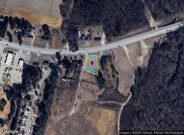
3535 Nc Highway 42 W, Wilson, NC 27893
NEARBY LISTINGS FOR SALE OR LEASE
Property Detail
3535 Nc Highway 42 W
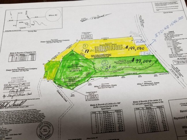
3701-48-1546.000
A Survey Solid Waste Disposal
Commercialnec
3535 NC 42 HWY W .48AC
AE
Wilson
3720370100K
North Carolina
2024
0.48 AC
2025
Rocky Mount/Wilson
001502
Other Market Areas
1,880 SF
Wilson, NC
DEMOGRAPHICS near 3535 Nc Highway 42 W
1 Mile
3 Mile
5 Mile
2024 Total Population
1,807
19,086
51,266
2029 Population
1,815
19,043
51,676
Pop Growth 2024-2029
+ 0.44%
(0.23%)
+ 0.80%
Average Age
41
42
41
2024 Total Households
806
8,104
21,360
HH Growth 2024-2029
+ 0.37%
(0.30%)
+ 0.76%
Median Household Inc
$48,678
$51,824
$48,039
Avg Household Size
2.20
2.30
2.30
2024 Avg HH Vehicles
2.00
2.00
2.00
Median Home Value
$149,735
$151,205
$152,502
Median Year Built
1998
1984
1984
Nearby Places
Map Layers
Map Styles
 Street
 Aerial
- Restaurants
- Banks
- Shops
- Fitness
- Groceries
PUBLIC TRANSPORTATION
COMMUTER RAIL
Wilson (Carolinian - Amtrak, Palmetto - Amtrak)
DRIVE
WALK
Distance
Wilson (Carolinian - Amtrak, Palmetto - Amtrak)
7 min
4.0 mi
Freight Ports
Port of Morehead City
DRIVE
WALK
Distance
Port of Morehead City
168 min
128.6 mi
SALE & LEASE HISTORY
LISTING DATE
SALE/LEASE

Apr 21, 2018
For Sale
Nearby Properties
Address
Land Use
TOTAL SIZE
Lot Size
Zoning
Address
Land Use
TOTAL SIZE
Lot Size
Zoning
125,586 SF
61.33 AC
HI
Address
Land Use
TOTAL SIZE
Lot Size
Zoning
25,554 SF
18.75 AC
RMX
Address
Land Use
TOTAL SIZE
Lot Size
Zoning
11,771 SF
31.78 AC
ICD
Address
Land Use
TOTAL SIZE
Lot Size
Zoning
624 SF
216.49 AC
M2
Address
Land Use
TOTAL SIZE
Lot Size
Zoning
232,805 SF
49.53 AC
HI
Address
Land Use
TOTAL SIZE
Lot Size
Zoning
159,765 SF
74.19 AC
AR
Address
Land Use
TOTAL SIZE
Lot Size
Zoning
11,375 SF
29.21 AC
HI
Address
Land Use
TOTAL SIZE
Lot Size
Zoning
4,803 SF
10.23 AC
RMX
Address
Land Use
TOTAL SIZE
Lot Size
Zoning
98,777 SF
50 AC
ICD
Address
Land Use
TOTAL SIZE
Lot Size
Zoning
150,316 SF
10.97 AC
RMX
Address
Land Use
TOTAL SIZE
Lot Size
Zoning
338,739 SF
29.79 AC
HI
Address
Land Use
TOTAL SIZE
Lot Size
Zoning
185,515 SF
19.58 AC
HC
Address
Land Use
TOTAL SIZE
Lot Size
Zoning
11,664 SF
10.13 AC
HC
Address
Land Use
TOTAL SIZE
Lot Size
Zoning
11,760 SF
56.76 AC
ICD
Address
Land Use
TOTAL SIZE
Lot Size
Zoning
135,620 SF
31.85 AC
HI
Address
Land Use
TOTAL SIZE
Lot Size
Zoning
78,875 SF
34.82 AC
ICD
Address
Land Use
TOTAL SIZE
Lot Size
Zoning
111,191 SF
10.64 AC
B4
Address
Land Use
TOTAL SIZE
Lot Size
Zoning
133,549 SF
21.49 AC
HC
Address
Land Use
TOTAL SIZE
Lot Size
Zoning
1,944 SF
13.64 AC
GR6
Address
Land Use
TOTAL SIZE
Lot Size
Zoning
8,616 SF
40 AC
ICD
Address
Land Use
TOTAL SIZE
Lot Size
Zoning
27,488 SF
17.21 AC
GR6
Address
Land Use
TOTAL SIZE
Lot Size
Zoning
12,560 SF
11.89 AC
HC
Address
Land Use
TOTAL SIZE
Lot Size
Zoning
3,900 SF
16.46 AC
RMX
Address
Land Use
TOTAL SIZE
Lot Size
Zoning
112,721 SF
22.04 AC
GC
Address
Land Use
TOTAL SIZE
Lot Size
Zoning
7,350 SF
9.09 AC
GC
Address
Land Use
TOTAL SIZE
Lot Size
Zoning
17,136 SF
9.81 AC
GC
Address
Land Use
TOTAL SIZE
Lot Size
Zoning
30,676 SF
9.09 AC
GC
Address
Land Use
TOTAL SIZE
Lot Size
Zoning
17,859 SF
8 AC
SR4
Address
Land Use
TOTAL SIZE
Lot Size
Zoning
39,321 SF
5.55 AC
ICD
Address
Land Use
TOTAL SIZE
Lot Size
Zoning
8,800 SF
7.51 AC
GC
The World's #1 Commercial Real Estate Marketplace
Connect with us
© 2025 CoStar Group
The information above has been obtained from sources believed reliable. While we do not doubt its accuracy we have not verified it and make no guarantee, warranty or representation about it. It is your responsibility to independently confirm its accuracy and completeness. Any projections, opinions, assumptions, or estimates used are for example only and do not represent the current or future performance of the property. The value of this transaction to you depends on tax and other factors which should be evaluated by your tax, financial, and legal advisors. You and your advisors should conduct a careful, independent investigation of the property to determine to your satisfaction the suitability of the property for your needs.