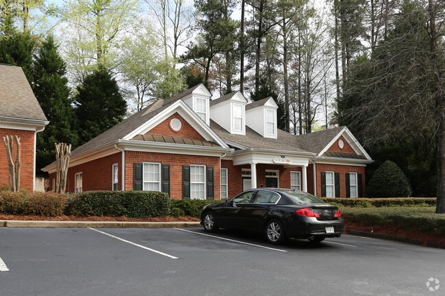
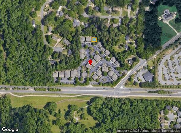
Property Record
3535 Roswell Rd, Marietta, GA 30062

Current Lease Availabilities
NEARBY LISTINGS FOR SALE OR LEASE
Property Detail
3535 Roswell Rd
16-0907-0-121-0
Cobb
Officecondo
Georgia
AE
31
13067C0127H
0.03 AC
2025
East Cobb
2025
Atlanta
030332
Atlanta-Sandy Springs-Roswell, GA
1,124 SF
DEMOGRAPHICS near 3535 Roswell Rd
1 Mile
3 Mile
5 Mile
2024 Total Population
6,977
69,763
194,728
2029 Population
7,034
70,249
197,479
Pop Growth 2024-2029
+ 0.82%
+ 0.70%
+ 1.41%
Average Age
41
42
40
2024 Total Households
2,283
24,681
73,262
HH Growth 2024-2029
+ 0.74%
+ 0.67%
+ 1.44%
Median Household Inc
$153,646
$143,737
$110,036
Avg Household Size
3.00
2.80
2.60
2024 Avg HH Vehicles
2.00
2.00
2.00
Median Home Value
$470,789
$481,814
$451,199
Median Year Built
1980
1982
1982
Nearby Places
- Restaurants
- Banks
- Shops
- Fitness
- Groceries
PUBLIC TRANSPORTATION
AIRPORT
Hartsfield - Jackson Atlanta International
DRIVE
WALK
Distance
Hartsfield - Jackson Atlanta International
43 min
30.3 mi
Freight Ports
Georgia Ports - Savannah
DRIVE
WALK
Distance
Georgia Ports - Savannah
306 min
269.6 mi
Nearby Properties
Address
Land Use
TOTAL SIZE
Lot Size
Zoning
Address
Land Use
TOTAL SIZE
Lot Size
Zoning
258,955 SF
29.70 AC
CRC/LRO
Address
Land Use
TOTAL SIZE
Lot Size
Zoning
300,105 SF
43.12 AC
RM-8
Address
Land Use
TOTAL SIZE
Lot Size
Zoning
3,406 SF
23.20 AC
R20
Address
Land Use
TOTAL SIZE
Lot Size
Zoning
285,846 SF
19.21 AC
PRD MF
Address
Land Use
TOTAL SIZE
Lot Size
Zoning
228,652 SF
24.19 AC
RM-12
Address
Land Use
TOTAL SIZE
Lot Size
Zoning
166,048 SF
20.29 AC
GC
Address
Land Use
TOTAL SIZE
Lot Size
Zoning
194,453 SF
17.71 AC
CRC/WS
Address
Land Use
TOTAL SIZE
Lot Size
Zoning
240,628 SF
30.90 AC
RM-8
Address
Land Use
TOTAL SIZE
Lot Size
Zoning
254,242 SF
17.48 AC
RM-8
Address
Land Use
TOTAL SIZE
Lot Size
Zoning
152,191 SF
9.63 AC
RSL
Address
Land Use
TOTAL SIZE
Lot Size
Zoning
119,776 SF
11.17 AC
NS/WS
Address
Land Use
TOTAL SIZE
Lot Size
Zoning
92,787 SF
11.69 AC
CRC/NS
Address
Land Use
TOTAL SIZE
Lot Size
Zoning
146,089 SF
10.29 AC
PRD MF
Address
Land Use
TOTAL SIZE
Lot Size
Zoning
167,727 SF
13.40 AC
CRC
Address
Land Use
TOTAL SIZE
Lot Size
Zoning
182,506 SF
8.49 AC
RSL
Address
Land Use
TOTAL SIZE
Lot Size
Zoning
106,968 SF
0.77 AC
PSC
Address
Land Use
TOTAL SIZE
Lot Size
Zoning
1,576 SF
3.24 AC
RSL
Address
Land Use
TOTAL SIZE
Lot Size
Zoning
84,299 SF
13.83 AC
GC
Address
Land Use
TOTAL SIZE
Lot Size
Zoning
67,397 SF
7.59 AC
NS
Address
Land Use
TOTAL SIZE
Lot Size
Zoning
117,668 SF
12.17 AC
PSC
Address
Land Use
TOTAL SIZE
Lot Size
Zoning
78,103 SF
8.54 AC
CRC/WS
Address
Land Use
TOTAL SIZE
Lot Size
Zoning
84,473 SF
13.06 AC
NRC
Address
Land Use
TOTAL SIZE
Lot Size
Zoning
64,015 SF
4.37 AC
CRC/WS
Address
Land Use
TOTAL SIZE
Lot Size
Zoning
239,207 SF
8.78 AC
GC/WS
Address
Land Use
TOTAL SIZE
Lot Size
Zoning
44,346 SF
4.46 AC
CRC
Address
Land Use
TOTAL SIZE
Lot Size
Zoning
88,450 SF
9.19 AC
RM-8
Address
Land Use
TOTAL SIZE
Lot Size
Zoning
93,007 SF
11.65 AC
NRC/WS
Address
Land Use
TOTAL SIZE
Lot Size
Zoning
128,491 SF
9.09 AC
OI
Address
Land Use
TOTAL SIZE
Lot Size
Zoning
103,084 SF
12.34 AC
GC
Address
Land Use
TOTAL SIZE
Lot Size
Zoning
59,632 SF
2.40 AC
OI
The World's #1 Commercial Real Estate Marketplace
Connect with us
© 2025 CoStar Group
The information above has been obtained from sources believed reliable. While we do not doubt its accuracy we have not verified it and make no guarantee, warranty or representation about it. It is your responsibility to independently confirm its accuracy and completeness. Any projections, opinions, assumptions, or estimates used are for example only and do not represent the current or future performance of the property. The value of this transaction to you depends on tax and other factors which should be evaluated by your tax, financial, and legal advisors. You and your advisors should conduct a careful, independent investigation of the property to determine to your satisfaction the suitability of the property for your needs.