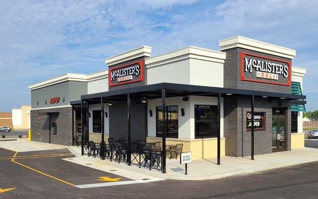
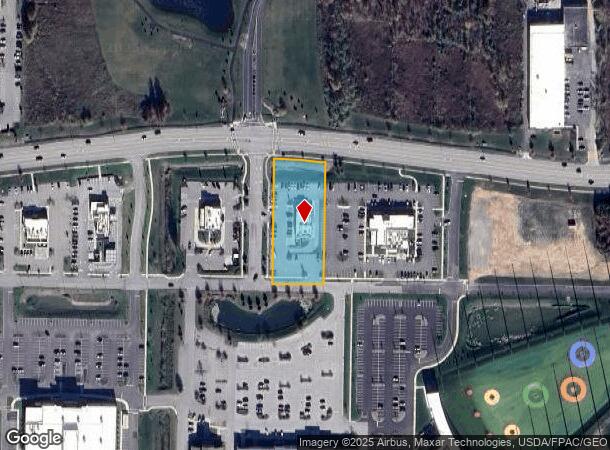
Property Record
35355 Chester Rd, Avon, OH 44011
NEARBY LISTINGS FOR SALE OR LEASE
Property Detail
35355 Chester Rd
Cleveland
Chester Road Sub. No. 5
Cleveland-Elyria, OH
CHESTER ROAD SUB. NO. 5
04-00-021-000-305
Lorain
Restaurantdrivein
Ohio
2024
12
2024
1.24 AC
013101
Lorain County
3,600 SF
DEMOGRAPHICS near 35355 Chester Rd
1 Mile
3 Mile
5 Mile
2024 Total Population
2,216
47,306
112,210
2029 Population
2,316
48,474
114,067
Pop Growth 2024-2029
+ 4.51%
+ 2.47%
+ 1.65%
Average Age
44
42
43
2024 Total Households
892
18,127
44,595
HH Growth 2024-2029
+ 4.60%
+ 2.34%
+ 1.54%
Median Household Inc
$97,655
$109,817
$96,565
Avg Household Size
2.40
2.60
2.50
2024 Avg HH Vehicles
2.00
2.00
2.00
Median Home Value
$326,562
$338,457
$285,827
Median Year Built
2003
1994
1986
Nearby Places
Map Layers
Map Styles
 Street
 Aerial
- Restaurants
- Banks
- Shops
- Fitness
- Groceries
PUBLIC TRANSPORTATION
COMMUTER RAIL
Elyria Amtrak (Capitol Limited - Amtrak, Lake Shore Limited - Amtrak)
DRIVE
WALK
Distance
Elyria Amtrak (Capitol Limited - Amtrak, Lake Shore Limited - Amtrak)
17 min
9.6 mi
AIRPORT
Cleveland-Hopkins International
DRIVE
WALK
Distance
Cleveland-Hopkins International
25 min
13.0 mi
Freight Ports
Port of Toledo
DRIVE
WALK
Distance
Port of Toledo
114 min
95.4 mi
SALE & LEASE HISTORY
LISTING DATE
SALE/LEASE

Mar 02, 2023
For Sale
Nearby Properties
Address
Land Use
TOTAL SIZE
Lot Size
Zoning
Address
Land Use
TOTAL SIZE
Lot Size
Zoning
1,239,072 SF
26.47 AC
PUD
Address
Land Use
TOTAL SIZE
Lot Size
Zoning
634,322 SF
82.83 AC
Address
Land Use
TOTAL SIZE
Lot Size
Zoning
221,566 SF
26.09 AC
Address
Land Use
TOTAL SIZE
Lot Size
Zoning
115,677 SF
33.09 AC
EI
Address
Land Use
TOTAL SIZE
Lot Size
Zoning
156,541 SF
31.07 AC
Address
Land Use
TOTAL SIZE
Lot Size
Zoning
318,927 SF
8 AC
Address
Land Use
TOTAL SIZE
Lot Size
Zoning
67,074 SF
8.08 AC
Address
Land Use
TOTAL SIZE
Lot Size
Zoning
163,892 SF
46.81 AC
Address
Land Use
TOTAL SIZE
Lot Size
Zoning
264,435 SF
25.85 AC
SC
Address
Land Use
TOTAL SIZE
Lot Size
Zoning
148,688 SF
17.15 AC
Address
Land Use
TOTAL SIZE
Lot Size
Zoning
116,942 SF
37.28 AC
Address
Land Use
TOTAL SIZE
Lot Size
Zoning
45,810 SF
36.64 AC
EI
Address
Land Use
TOTAL SIZE
Lot Size
Zoning
553,692 SF
80.04 AC
Address
Land Use
TOTAL SIZE
Lot Size
Zoning
116,057 SF
22.35 AC
Address
Land Use
TOTAL SIZE
Lot Size
Zoning
194,392 SF
11.18 AC
Address
Land Use
TOTAL SIZE
Lot Size
Zoning
17,121 SF
19.06 AC
R-MF24
Address
Land Use
TOTAL SIZE
Lot Size
Zoning
92,376 SF
18.58 AC
Address
Land Use
TOTAL SIZE
Lot Size
Zoning
244,016 SF
26.43 AC
Address
Land Use
TOTAL SIZE
Lot Size
Zoning
42,142 SF
5.37 AC
Address
Land Use
TOTAL SIZE
Lot Size
Zoning
70,474 SF
38.47 AC
Address
Land Use
TOTAL SIZE
Lot Size
Zoning
163,038 SF
21.16 AC
Address
Land Use
TOTAL SIZE
Lot Size
Zoning
194,868 SF
23.21 AC
Address
Land Use
TOTAL SIZE
Lot Size
Zoning
34,908 SF
21.46 AC
Address
Land Use
TOTAL SIZE
Lot Size
Zoning
58,594 SF
12.67 AC
Address
Land Use
TOTAL SIZE
Lot Size
Zoning
67,590 SF
23.66 AC
Address
Land Use
TOTAL SIZE
Lot Size
Zoning
63,135 SF
9.85 AC
Address
Land Use
TOTAL SIZE
Lot Size
Zoning
111,856 SF
0.99 AC
Address
Land Use
TOTAL SIZE
Lot Size
Zoning
146,094 SF
15.29 AC
Address
Land Use
TOTAL SIZE
Lot Size
Zoning
195,756 SF
19.36 AC
Address
Land Use
TOTAL SIZE
Lot Size
Zoning
26,486 SF
13.44 AC
The World's #1 Commercial Real Estate Marketplace
Connect with us
© 2025 CoStar Group
The information above has been obtained from sources believed reliable. While we do not doubt its accuracy we have not verified it and make no guarantee, warranty or representation about it. It is your responsibility to independently confirm its accuracy and completeness. Any projections, opinions, assumptions, or estimates used are for example only and do not represent the current or future performance of the property. The value of this transaction to you depends on tax and other factors which should be evaluated by your tax, financial, and legal advisors. You and your advisors should conduct a careful, independent investigation of the property to determine to your satisfaction the suitability of the property for your needs.