Property Record
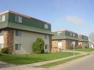
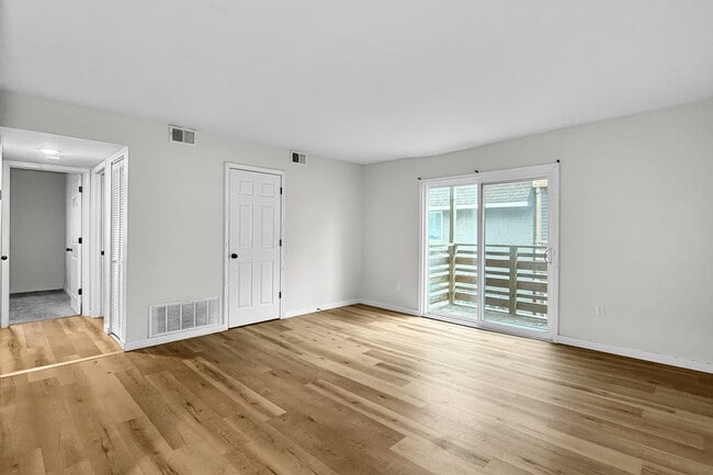
3553 Heatherton Dr, Davenport, IA 52804
This Property Is For Sale
NEARBY LISTINGS FOR SALE OR LEASE
Property Detail
3553 Heatherton Dr
Davenport-Moline-Rock Island, IA-IL
Heatherton Heights 13Th Add
O2101A14
HEATHERTON HEIGHTS 13TH ADD LOT: 022 HEATHERTON HEIGHTS13TH ADD
Apartment
Scott
X
Iowa
19163C0345H
22
2025
0.35 AC
2025
Northwest Davenport
012501
Davenport/Moline/Rock Island
9,504 SF
DEMOGRAPHICS near 3553 Heatherton Dr
1 Mile
3 Mile
5 Mile
2024 Total Population
7,560
58,878
108,427
2029 Population
7,508
58,390
107,964
Pop Growth 2024-2029
(0.69%)
(0.83%)
(0.43%)
Average Age
41
40
39
2024 Total Households
3,081
23,755
45,395
HH Growth 2024-2029
(0.71%)
(0.89%)
(0.44%)
Median Household Inc
$59,117
$55,280
$53,812
Avg Household Size
2.40
2.30
2.30
2024 Avg HH Vehicles
2.00
2.00
2.00
Median Home Value
$152,484
$143,300
$145,026
Median Year Built
1970
1963
1961
Nearby Places
Map Layers
Map Styles
 Street
 Aerial
- Restaurants
- Banks
- Shops
- Fitness
- Groceries
PUBLIC TRANSPORTATION
AIRPORT
Quad Cities International
DRIVE
WALK
Distance
Quad Cities International
27 min
13.4 mi
Freight Ports
Port Milwaukee
DRIVE
WALK
Distance
Port Milwaukee
248 min
216.3 mi
Nearby Properties
Address
Land Use
TOTAL SIZE
Lot Size
Zoning
Address
Land Use
TOTAL SIZE
Lot Size
Zoning
3,516 SF
26.74 AC
Address
Land Use
TOTAL SIZE
Lot Size
Zoning
300,718 SF
14.71 AC
Address
Land Use
TOTAL SIZE
Lot Size
Zoning
63,359 SF
12.01 AC
Address
Land Use
TOTAL SIZE
Lot Size
Zoning
352,332 SF
34.16 AC
Address
Land Use
TOTAL SIZE
Lot Size
Zoning
472,569 SF
47.24 AC
Address
Land Use
TOTAL SIZE
Lot Size
Zoning
77,187 SF
0.88 AC
Address
Land Use
TOTAL SIZE
Lot Size
Zoning
70,098 SF
9.72 AC
Address
Land Use
TOTAL SIZE
Lot Size
Zoning
86,976 SF
40 AC
Address
Land Use
TOTAL SIZE
Lot Size
Zoning
111,452 SF
40 AC
Address
Land Use
TOTAL SIZE
Lot Size
Zoning
12,648 SF
8.28 AC
Address
Land Use
TOTAL SIZE
Lot Size
Zoning
54,644 SF
2.41 AC
Address
Land Use
TOTAL SIZE
Lot Size
Zoning
213,686 SF
23.29 AC
Address
Land Use
TOTAL SIZE
Lot Size
Zoning
3,000 SF
59.92 AC
Address
Land Use
TOTAL SIZE
Lot Size
Zoning
54,026 SF
Address
Land Use
TOTAL SIZE
Lot Size
Zoning
43,343 SF
3.56 AC
Address
Land Use
TOTAL SIZE
Lot Size
Zoning
70,974 SF
13.14 AC
Address
Land Use
TOTAL SIZE
Lot Size
Zoning
25,200 SF
23.19 AC
Address
Land Use
TOTAL SIZE
Lot Size
Zoning
43,360 SF
2.92 AC
Address
Land Use
TOTAL SIZE
Lot Size
Zoning
25,803 SF
2 AC
Address
Land Use
TOTAL SIZE
Lot Size
Zoning
1,080 SF
16.40 AC
Address
Land Use
TOTAL SIZE
Lot Size
Zoning
12,969 SF
3.94 AC
Address
Land Use
TOTAL SIZE
Lot Size
Zoning
20,000 SF
8.59 AC
Address
Land Use
TOTAL SIZE
Lot Size
Zoning
86,754 SF
1.11 AC
Address
Land Use
TOTAL SIZE
Lot Size
Zoning
21,999 SF
22 AC
Address
Land Use
TOTAL SIZE
Lot Size
Zoning
77,870 SF
6.37 AC
Address
Land Use
TOTAL SIZE
Lot Size
Zoning
249,537 SF
44.45 AC
Address
Land Use
TOTAL SIZE
Lot Size
Zoning
11,192 SF
9.55 AC
Address
Land Use
TOTAL SIZE
Lot Size
Zoning
10,758 SF
34.12 AC
Address
Land Use
TOTAL SIZE
Lot Size
Zoning
14,947 SF
26.21 AC
Address
Land Use
TOTAL SIZE
Lot Size
Zoning
60,812 SF
1.92 AC
The World's #1 Commercial Real Estate Marketplace
Connect with us
© 2025 CoStar Group
The information above has been obtained from sources believed reliable. While we do not doubt its accuracy we have not verified it and make no guarantee, warranty or representation about it. It is your responsibility to independently confirm its accuracy and completeness. Any projections, opinions, assumptions, or estimates used are for example only and do not represent the current or future performance of the property. The value of this transaction to you depends on tax and other factors which should be evaluated by your tax, financial, and legal advisors. You and your advisors should conduct a careful, independent investigation of the property to determine to your satisfaction the suitability of the property for your needs.