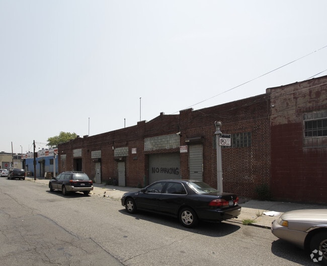
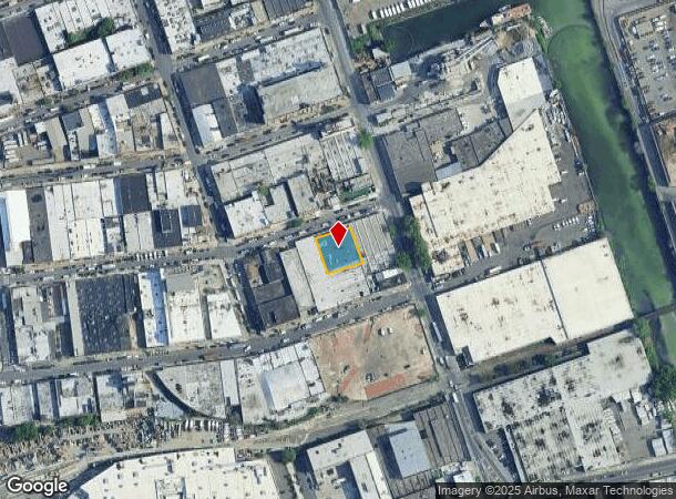
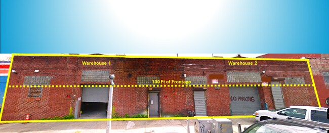
Property Record
354 Scholes St, Brooklyn, NY 11206
NEARBY LISTINGS FOR SALE OR LEASE
Property Detail
354 Scholes St
03048-0014
ID2011052400059001
Lightindustrial
Kings
X
New York
3604970208F
14
2024
0.23 AC
2025
North Brooklyn
048500
Long Island (New York)
10,000 SF
New York-Jersey City-White Plains, NY-NJ
DEMOGRAPHICS near 354 Scholes St
1 mile
3 mile
5 mile
2024 Total Population
120,572
1,118,820
3,259,941
2029 Population
114,894
1,056,393
3,056,854
Pop Growth 2024-2029
(4.71%)
(5.58%)
(6.23%)
Average Age
36
37
39
2024 Total Households
47,973
452,381
1,362,445
HH Growth 2024-2029
(5.32%)
(5.93%)
(6.50%)
Median Household Inc
$73,509
$77,894
$83,991
Avg Household Size
2.40
2.40
2.30
2024 Avg HH Vehicles
.00
.00
.00
Median Home Value
$896,068
$869,495
$849,168
Median Year Built
1956
1949
1950
Nearby Places
Map Layers
Map Styles
 Street
 Aerial
Transit
 Traffic
 Biking
Places
Listings with unknown addresses are not visible on the map
- Restaurants
- Banks
- Shops
- Fitness
- Groceries
PUBLIC TRANSPORTATION
TRANSIT/SUBWAY
Morgan Avenue (L - New York MTA Subway (The Subway))
Drive
Walk
Distance
Morgan Avenue (L - New York MTA Subway (The Subway))
2 min
6 min
0.3 mi
Montrose Avenue (L - New York MTA Subway (The Subway))
Drive
Walk
Distance
Montrose Avenue (L - New York MTA Subway (The Subway))
3 min
8 min
0.4 mi
Grand Street (L Line) (L - New York MTA Subway (The Subway))
Drive
Walk
Distance
Grand Street (L Line) (L - New York MTA Subway (The Subway))
2 min
10 min
0.5 mi
Jefferson Street (L - New York MTA Subway (The Subway))
Drive
Walk
Distance
Jefferson Street (L - New York MTA Subway (The Subway))
3 min
15 min
0.8 mi
Graham Avenue (L - New York MTA Subway (The Subway))
Drive
Walk
Distance
Graham Avenue (L - New York MTA Subway (The Subway))
3 min
16 min
0.8 mi
COMMUTER RAIL
Nostrand Avenue Station (Far Rockaway Branch - Long Island Rail Road, Hempstead Branch - Long Island Rail Road, Long Beach Branch - Long Island Rail Road, West Hempstead Branch - Long Island Rail Road)
Drive
Walk
Distance
Nostrand Avenue Station (Far Rockaway Branch - Long Island Rail Road, Hempstead Branch - Long Island Rail Road, Long Beach Branch - Long Island Rail Road, West Hempstead Branch - Long Island Rail Road)
11 min
3.2 mi
Hunterspoint Avenue Station (Hempstead Branch - Long Island Rail Road, Oyster Bay Branch - Long Island Rail Road)
Drive
Walk
Distance
Hunterspoint Avenue Station (Hempstead Branch - Long Island Rail Road, Oyster Bay Branch - Long Island Rail Road)
9 min
3.3 mi
AIRPORT
LaGuardia
Drive
Walk
Distance
LaGuardia
14 min
6.9 mi
John F Kennedy International
Drive
Walk
Distance
John F Kennedy International
22 min
12.2 mi
Newark Liberty International
Drive
Walk
Distance
Newark Liberty International
29 min
16.0 mi
Freight Ports
NY - Red Hook Container Terminal
Drive
Walk
Distance
NY - Red Hook Container Terminal
13 min
5.9 mi
SALE & LEASE HISTORY
LISTING DATE
SALE/LEASE

Jun 14, 2023
For Sale
Jul 12, 2022
For Lease
Jan 10, 2023
For Sale
Jan 09, 2023
For Sale
Jan 09, 2023
For Sale
Jan 09, 2023
For Sale
Nearby Properties
Address
Land Use
TOTAL SIZE
Lot Size
Zoning
Address
Land Use
TOTAL SIZE
Lot Size
Zoning
8,462,176 SF
61.41 AC
R7-2
Address
Land Use
TOTAL SIZE
Lot Size
Zoning
2,812,739 SF
2.10 AC
C5-3
Address
Land Use
TOTAL SIZE
Lot Size
Zoning
1,104,505 SF
2.32 AC
C4-7
Address
Land Use
TOTAL SIZE
Lot Size
Zoning
7,058,736 SF
147.61 AC
M3-1
Address
Land Use
TOTAL SIZE
Lot Size
Zoning
869,038 SF
1.53 AC
M1-1
Address
Land Use
TOTAL SIZE
Lot Size
Zoning
3,122,165 SF
19.02 AC
R7-2
Address
Land Use
TOTAL SIZE
Lot Size
Zoning
1,065,915 SF
2.13 AC
M16R10
Address
Land Use
TOTAL SIZE
Lot Size
Zoning
1,385,425 SF
6.43 AC
R8
Address
Land Use
TOTAL SIZE
Lot Size
Zoning
986,641 SF
6.74 AC
R8
Address
Land Use
TOTAL SIZE
Lot Size
Zoning
986,641 SF
6.74 AC
R8
Address
Land Use
TOTAL SIZE
Lot Size
Zoning
986,641 SF
6.74 AC
R8
Address
Land Use
TOTAL SIZE
Lot Size
Zoning
986,641 SF
6.74 AC
R8
Address
Land Use
TOTAL SIZE
Lot Size
Zoning
986,641 SF
6.74 AC
R8
Address
Land Use
TOTAL SIZE
Lot Size
Zoning
986,641 SF
6.74 AC
R8
Address
Land Use
TOTAL SIZE
Lot Size
Zoning
986,641 SF
6.74 AC
R8
Address
Land Use
TOTAL SIZE
Lot Size
Zoning
986,641 SF
6.74 AC
R8
Address
Land Use
TOTAL SIZE
Lot Size
Zoning
986,641 SF
6.74 AC
R8
Address
Land Use
TOTAL SIZE
Lot Size
Zoning
986,641 SF
6.74 AC
R8
Address
Land Use
TOTAL SIZE
Lot Size
Zoning
986,641 SF
6.74 AC
R8
Address
Land Use
TOTAL SIZE
Lot Size
Zoning
986,641 SF
6.74 AC
R8
Address
Land Use
TOTAL SIZE
Lot Size
Zoning
986,641 SF
6.74 AC
R8
Address
Land Use
TOTAL SIZE
Lot Size
Zoning
986,641 SF
6.74 AC
R8
Address
Land Use
TOTAL SIZE
Lot Size
Zoning
986,641 SF
6.74 AC
R8
Address
Land Use
TOTAL SIZE
Lot Size
Zoning
986,641 SF
6.74 AC
R8
Address
Land Use
TOTAL SIZE
Lot Size
Zoning
986,641 SF
6.74 AC
R8
Address
Land Use
TOTAL SIZE
Lot Size
Zoning
986,641 SF
6.74 AC
R8
Address
Land Use
TOTAL SIZE
Lot Size
Zoning
986,641 SF
6.74 AC
R8
Address
Land Use
TOTAL SIZE
Lot Size
Zoning
986,641 SF
6.74 AC
R8
Address
Land Use
TOTAL SIZE
Lot Size
Zoning
986,641 SF
6.74 AC
R8
Address
Land Use
TOTAL SIZE
Lot Size
Zoning
986,641 SF
6.74 AC
R8
The World's #1 Commercial Real Estate Marketplace
Connect with us
© 2026 CoStar Group
The information above has been obtained from sources believed reliable. While we do not doubt its accuracy we have not verified it and make no guarantee, warranty or representation about it. It is your responsibility to independently confirm its accuracy and completeness. Any projections, opinions, assumptions, or estimates used are for example only and do not represent the current or future performance of the property. The value of this transaction to you depends on tax and other factors which should be evaluated by your tax, financial, and legal advisors. You and your advisors should conduct a careful, independent investigation of the property to determine to your satisfaction the suitability of the property for your needs.