Property Record
354 Shore Dr, Highlands, NJ 07732


Save to a Folder
{{folder.Name}}
{{folder.ListingIds.length}} Properties
{{folder.ListingIds.length}} Property
Create a New Folder
Property Detail
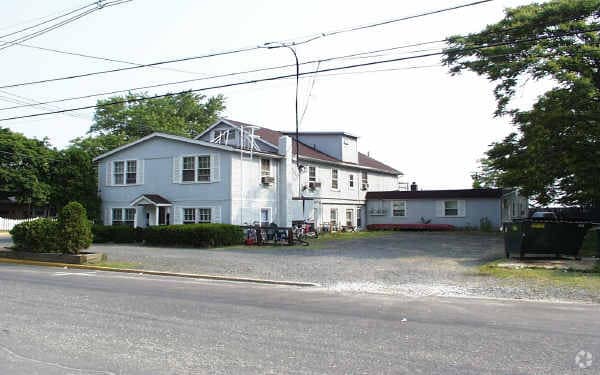
354 Shore Dr
19-00101-0000-00014
Monmouth
Commercialnec
New Jersey
SF0
14
AE The base floodplain where base flood elevations are provided. AE Zones are now used on new format FIRMs instead of A1-A30 Zones.
0.15 AC
2025
Highlands
2026
Northern New Jersey
800101
Lakewood-New Brunswick, NJ
4,156 SF
NEARBY LISTINGS FOR SALE OR LEASE
DEMOGRAPHICS near 354 Shore Dr
1 mile
3 mile
5 mile
2025 Total Population
5,686
20,518
46,163
2030 Population
5,884
20,721
46,326
Pop Growth 2025-2030
+ 3.48%
+ 0.99%
+ 0.35%
Average Age
46
45
43
2025 Total Households
2,861
8,871
18,294
HH Growth 2025-2030
+ 3.57%
+ 1.17%
+ 0.53%
Median Household Inc
$90,372
$121,680
$141,921
Avg Household Size
2.00
2.30
2.50
2025 Avg HH Vehicles
2.00
2.00
2.00
Median Home Value
$611,247
$764,567
$778,334
Median Year Built
1972
1969
1964
Nearby Places
Map Layers
Map Styles
 Street
 Aerial
Layers
 Traffic
 Biking
Places
Listings with unknown addresses are not visible on the map
- Restaurants
- Banks
- Shops
- Fitness
- Groceries
PUBLIC TRANSPORTATION
COMMUTER RAIL
Red Bank (North Jersey Coast Line - NJ Transit Commuter Rail (NJ Transit))
Drive
Walk
Distance
Red Bank (North Jersey Coast Line - NJ Transit Commuter Rail (NJ Transit))
16 min
7.9 mi
Drive
Walk
Distance
17 min
8.8 mi
AIRPORT
Newark Liberty International
Drive
Walk
Distance
Newark Liberty International
57 min
39.6 mi
Freight Ports
New York Container Terminal
Drive
Walk
Distance
New York Container Terminal
50 min
34.9 mi
Nearby Properties
Address
Land Use
TOTAL SIZE
Lot Size
Zoning
Address
Land Use
TOTAL SIZE
Lot Size
Zoning
167,221 SF
18.74 AC
CONREC
Address
Land Use
TOTAL SIZE
Lot Size
Zoning
35.84 AC
R22
Address
Land Use
TOTAL SIZE
Lot Size
Zoning
47,470 SF
15.43 AC
CONREC
Address
Land Use
TOTAL SIZE
Lot Size
Zoning
37 AC
H-BP
Address
Land Use
TOTAL SIZE
Lot Size
Zoning
1,800 SF
504.53 AC
SF80
Address
Land Use
TOTAL SIZE
Lot Size
Zoning
163,312 SF
16.21 AC
MF15
Address
Land Use
TOTAL SIZE
Lot Size
Zoning
15,866 SF
4.85 AC
SF40
Address
Land Use
TOTAL SIZE
Lot Size
Zoning
50,339 SF
10.50 AC
B3
Address
Land Use
TOTAL SIZE
Lot Size
Zoning
178 AC
R110
Address
Land Use
TOTAL SIZE
Lot Size
Zoning
1.77 AC
MF-2
Address
Land Use
TOTAL SIZE
Lot Size
Zoning
162.89 AC
R110
Address
Land Use
TOTAL SIZE
Lot Size
Zoning
23,090 SF
10.60 AC
C125
Address
Land Use
TOTAL SIZE
Lot Size
Zoning
74,620 SF
0.87 AC
MF08
Address
Land Use
TOTAL SIZE
Lot Size
Zoning
1,972 SF
95.96 AC
R110
Address
Land Use
TOTAL SIZE
Lot Size
Zoning
6,168 SF
13.24 AC
Address
Land Use
TOTAL SIZE
Lot Size
Zoning
93,620 SF
11.86 AC
SF05
Address
Land Use
TOTAL SIZE
Lot Size
Zoning
5.32 AC
RTH9
Address
Land Use
TOTAL SIZE
Lot Size
Zoning
23,778 SF
1.55 AC
SF0
Address
Land Use
TOTAL SIZE
Lot Size
Zoning
8,679 SF
1.68 AC
SF80
Address
Land Use
TOTAL SIZE
Lot Size
Zoning
4.37 AC
CONREC
Address
Land Use
TOTAL SIZE
Lot Size
Zoning
20,245 SF
1.14 AC
R110
Address
Land Use
TOTAL SIZE
Lot Size
Zoning
10,104 SF
1.47 AC
SF80
Address
Land Use
TOTAL SIZE
Lot Size
Zoning
44,755 SF
14.47 AC
B3
Address
Land Use
TOTAL SIZE
Lot Size
Zoning
1,980 SF
71.08 AC
C125
Address
Land Use
TOTAL SIZE
Lot Size
Zoning
59,906 SF
2.05 AC
SF05
Address
Land Use
TOTAL SIZE
Lot Size
Zoning
33,784 SF
6.55 AC
MF08
Address
Land Use
TOTAL SIZE
Lot Size
Zoning
25,043 SF
54.66 AC
R22
Address
Land Use
TOTAL SIZE
Lot Size
Zoning
228 SF
3.55 AC
CONREC
Address
Land Use
TOTAL SIZE
Lot Size
Zoning
44,039 SF
5.78 AC
SF10
Address
Land Use
TOTAL SIZE
Lot Size
Zoning
43,588 SF
3.26 AC
HB
The World's #1 Commercial Real Estate Marketplace
Connect with us
© 2026 CoStar Group
The information above has been obtained from sources believed reliable. While we do not doubt its accuracy we have not verified it and make no guarantee, warranty or representation about it. It is your responsibility to independently confirm its accuracy and completeness. Any projections, opinions, assumptions, or estimates used are for example only and do not represent the current or future performance of the property. The value of this transaction to you depends on tax and other factors which should be evaluated by your tax, financial, and legal advisors. You and your advisors should conduct a careful, independent investigation of the property to determine to your satisfaction the suitability of the property for your needs.