Property Record
3541 W 5Th St, Oxnard, CA 93030
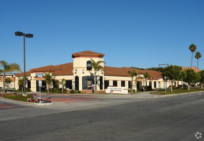

Property Detail
3541 W 5Th St
Oxnard-Thousand Oaks-Ventura, CA
LOT: 4 REF: 58 PM 46
185-0-190-050
Ventura
Storebuilding
California
2024
4
2025
3.51 AC
002905
Oxnard/Port Hueneme
40,980 SF
Los Angeles
NEARBY LISTINGS FOR SALE OR LEASE
DEMOGRAPHICS near 3541 W 5Th St
1 mile
3 mile
5 mile
2024 Total Population
10,027
121,946
255,351
2029 Population
9,991
121,270
253,672
Pop Growth 2024-2029
(0.36%)
(0.55%)
(0.66%)
Average Age
42
39
38
2024 Total Households
3,357
35,524
73,559
HH Growth 2024-2029
(0.15%)
(0.21%)
(0.46%)
Median Household Inc
$102,923
$92,198
$92,738
Avg Household Size
3.00
3.30
3.30
2024 Avg HH Vehicles
2.00
2.00
2.00
Median Home Value
$763,237
$746,202
$706,972
Median Year Built
1979
1974
1975
Nearby Places
Map Layers
Map Styles
 Street
 Aerial
Transit
 Traffic
 Biking
Places
Listings with unknown addresses are not visible on the map
- Restaurants
- Banks
- Shops
- Fitness
- Groceries
PUBLIC TRANSPORTATION
COMMUTER RAIL
Oxnard (Ventura County Line - Southern California Regional Rail Authority (Metrolink))
Drive
Walk
Distance
Oxnard (Ventura County Line - Southern California Regional Rail Authority (Metrolink))
6 min
2.7 mi
East Ventura Metrolink Station (Metrolink Ventura County Line - Metrolink Trains)
Drive
Walk
Distance
East Ventura Metrolink Station (Metrolink Ventura County Line - Metrolink Trains)
7 min
4.6 mi
Freight Ports
The Port of Hueneme
Drive
Walk
Distance
The Port of Hueneme
10 min
4.9 mi
SALE & LEASE HISTORY
LISTING DATE
SALE/LEASE

Sep 25, 2016
For Lease
Nearby Properties
Address
Land Use
TOTAL SIZE
Lot Size
Zoning
Address
Land Use
TOTAL SIZE
Lot Size
Zoning
241,298 SF
8 AC
R3C
Address
Land Use
TOTAL SIZE
Lot Size
Zoning
11.28 AC
CMPD
Address
Land Use
TOTAL SIZE
Lot Size
Zoning
166,920 SF
7.15 AC
R3PD
Address
Land Use
TOTAL SIZE
Lot Size
Zoning
191,035 SF
8.54 AC
R3PD
Address
Land Use
TOTAL SIZE
Lot Size
Zoning
158,736 SF
6.33 AC
Address
Land Use
TOTAL SIZE
Lot Size
Zoning
129,018 SF
5.09 AC
R3PD
Address
Land Use
TOTAL SIZE
Lot Size
Zoning
770 SF
9.80 AC
M1
Address
Land Use
TOTAL SIZE
Lot Size
Zoning
20,349 SF
9.65 AC
C2
Address
Land Use
TOTAL SIZE
Lot Size
Zoning
13,189 SF
10.58 AC
Address
Land Use
TOTAL SIZE
Lot Size
Zoning
7.95 AC
M2
Address
Land Use
TOTAL SIZE
Lot Size
Zoning
Address
Land Use
TOTAL SIZE
Lot Size
Zoning
94,375 SF
7.94 AC
Address
Land Use
TOTAL SIZE
Lot Size
Zoning
51,694 SF
2.75 AC
Address
Land Use
TOTAL SIZE
Lot Size
Zoning
1,800 SF
8.84 AC
M1
Address
Land Use
TOTAL SIZE
Lot Size
Zoning
14,931 SF
14.08 AC
Address
Land Use
TOTAL SIZE
Lot Size
Zoning
2,320 SF
12.02 AC
M1
Address
Land Use
TOTAL SIZE
Lot Size
Zoning
70,600 SF
3.75 AC
R3PD
Address
Land Use
TOTAL SIZE
Lot Size
Zoning
98,276 SF
14 AC
R3
Address
Land Use
TOTAL SIZE
Lot Size
Zoning
56,230 SF
1.19 AC
Address
Land Use
TOTAL SIZE
Lot Size
Zoning
71,845 SF
3.01 AC
COPD
Address
Land Use
TOTAL SIZE
Lot Size
Zoning
99,183 SF
4.31 AC
R4
Address
Land Use
TOTAL SIZE
Lot Size
Zoning
98,609 SF
3.96 AC
M1
Address
Land Use
TOTAL SIZE
Lot Size
Zoning
52,060 SF
4.61 AC
C2PD
Address
Land Use
TOTAL SIZE
Lot Size
Zoning
59,232 SF
2.46 AC
R4
Address
Land Use
TOTAL SIZE
Lot Size
Zoning
86,627 SF
6.59 AC
CMPD
Address
Land Use
TOTAL SIZE
Lot Size
Zoning
57,224 SF
3.17 AC
R1
Address
Land Use
TOTAL SIZE
Lot Size
Zoning
1,316 SF
3.86 AC
Address
Land Use
TOTAL SIZE
Lot Size
Zoning
75,685 SF
3.09 AC
Address
Land Use
TOTAL SIZE
Lot Size
Zoning
11,072 SF
12.16 AC
C2PD
Address
Land Use
TOTAL SIZE
Lot Size
Zoning
65,046 SF
2.20 AC
CBD
The World's #1 Commercial Real Estate Marketplace
Connect with us
© 2026 CoStar Group
The information above has been obtained from sources believed reliable. While we do not doubt its accuracy we have not verified it and make no guarantee, warranty or representation about it. It is your responsibility to independently confirm its accuracy and completeness. Any projections, opinions, assumptions, or estimates used are for example only and do not represent the current or future performance of the property. The value of this transaction to you depends on tax and other factors which should be evaluated by your tax, financial, and legal advisors. You and your advisors should conduct a careful, independent investigation of the property to determine to your satisfaction the suitability of the property for your needs.