Property Record
3543 Robinhood Rd, Winston Salem, NC 27106
NEARBY LISTINGS FOR SALE OR LEASE
Property Detail
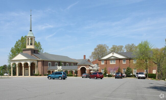
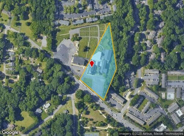
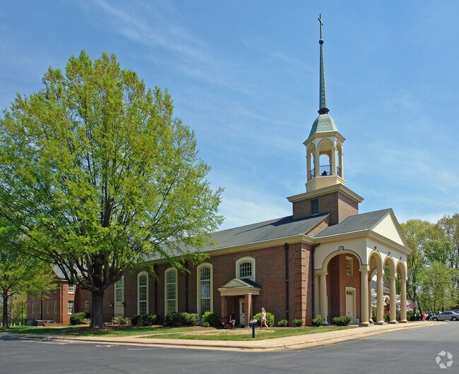
3543 Robinhood Rd
Winston-Salem, NC
Mt Tabor Methodist Church
6806-95-9565
MT TABOR METHODIST CHURCH LO:001A BL:3406 BU:1
Religious
Forsyth
X
North Carolina
3710680600J
1a
0
3.86 AC
2025
Western Forsyth County
002605
Greensboro/Winston-Salem
23,775 SF
DEMOGRAPHICS near 3543 Robinhood Rd
1 Mile
3 Mile
5 Mile
2024 Total Population
5,957
55,211
150,825
2029 Population
6,160
57,229
157,198
Pop Growth 2024-2029
+ 3.41%
+ 3.66%
+ 4.23%
Average Age
43
41
40
2024 Total Households
2,617
22,798
64,819
HH Growth 2024-2029
+ 3.40%
+ 3.82%
+ 4.35%
Median Household Inc
$91,978
$82,694
$62,286
Avg Household Size
2.30
2.20
2.20
2024 Avg HH Vehicles
2.00
2.00
2.00
Median Home Value
$325,055
$319,380
$255,244
Median Year Built
1978
1980
1979
Nearby Places
Map Layers
Map Styles
 Street
 Aerial
- Restaurants
- Banks
- Shops
- Fitness
- Groceries
PUBLIC TRANSPORTATION
AIRPORT
Piedmont Triad International
DRIVE
WALK
Distance
Piedmont Triad International
43 min
26.9 mi
Freight Ports
Virginia Port Authority - Richmond
DRIVE
WALK
Distance
Virginia Port Authority - Richmond
270 min
230.5 mi
Nearby Properties
Address
Land Use
TOTAL SIZE
Lot Size
Zoning
Address
Land Use
TOTAL SIZE
Lot Size
Zoning
100 SF
213.71 AC
C
Address
Land Use
TOTAL SIZE
Lot Size
Zoning
316,648 SF
30.46 AC
GB
Address
Land Use
TOTAL SIZE
Lot Size
Zoning
128,592 SF
28.33 AC
GB-S
Address
Land Use
TOTAL SIZE
Lot Size
Zoning
205,778 SF
4.75 AC
GB
Address
Land Use
TOTAL SIZE
Lot Size
Zoning
61,125 SF
8.66 AC
MU-S
Address
Land Use
TOTAL SIZE
Lot Size
Zoning
188,135 SF
8.65 AC
GO-S
Address
Land Use
TOTAL SIZE
Lot Size
Zoning
127,566 SF
35.86 AC
C-L
Address
Land Use
TOTAL SIZE
Lot Size
Zoning
125,015 SF
33.69 AC
LO-S,RM8-S
Address
Land Use
TOTAL SIZE
Lot Size
Zoning
91,905 SF
21.18 AC
RM18-S
Address
Land Use
TOTAL SIZE
Lot Size
Zoning
106,821 SF
14.95 AC
RM12-S
Address
Land Use
TOTAL SIZE
Lot Size
Zoning
275,051 SF
32.47 AC
PB-S,RM18
Address
Land Use
TOTAL SIZE
Lot Size
Zoning
139,775 SF
11.57 AC
HB,RS9
Address
Land Use
TOTAL SIZE
Lot Size
Zoning
115,352 SF
11.21 AC
RM8-S
Address
Land Use
TOTAL SIZE
Lot Size
Zoning
68,118 SF
12.74 AC
MU-S
Address
Land Use
TOTAL SIZE
Lot Size
Zoning
106,941 SF
10.91 AC
RM12-S
Address
Land Use
TOTAL SIZE
Lot Size
Zoning
82,843 SF
16.06 AC
RM18
Address
Land Use
TOTAL SIZE
Lot Size
Zoning
179,142 SF
42.52 AC
RS9
Address
Land Use
TOTAL SIZE
Lot Size
Zoning
120,118 SF
15.71 AC
RM18
Address
Land Use
TOTAL SIZE
Lot Size
Zoning
141,377 SF
37.07 AC
IP
Address
Land Use
TOTAL SIZE
Lot Size
Zoning
72,782 SF
15.72 AC
RM12-S,RS9
Address
Land Use
TOTAL SIZE
Lot Size
Zoning
67,643 SF
19.19 AC
RM12-S
Address
Land Use
TOTAL SIZE
Lot Size
Zoning
127,029 SF
6.22 AC
GB,RS12
Address
Land Use
TOTAL SIZE
Lot Size
Zoning
73,930 SF
18 AC
RM12-S
Address
Land Use
TOTAL SIZE
Lot Size
Zoning
98,061 SF
15.87 AC
RM12-S,RM1
Address
Land Use
TOTAL SIZE
Lot Size
Zoning
113,351 SF
11.87 AC
MU-S
Address
Land Use
TOTAL SIZE
Lot Size
Zoning
89,957 SF
14.65 AC
RM18
Address
Land Use
TOTAL SIZE
Lot Size
Zoning
71,255 SF
6.19 AC
C
Address
Land Use
TOTAL SIZE
Lot Size
Zoning
93,541 SF
10.75 AC
RM18
Address
Land Use
TOTAL SIZE
Lot Size
Zoning
57,152 SF
9.82 AC
RM18-S
Address
Land Use
TOTAL SIZE
Lot Size
Zoning
64,385 SF
8.13 AC
GB-L
The World's #1 Commercial Real Estate Marketplace
Connect with us
© 2026 CoStar Group
The information above has been obtained from sources believed reliable. While we do not doubt its accuracy we have not verified it and make no guarantee, warranty or representation about it. It is your responsibility to independently confirm its accuracy and completeness. Any projections, opinions, assumptions, or estimates used are for example only and do not represent the current or future performance of the property. The value of this transaction to you depends on tax and other factors which should be evaluated by your tax, financial, and legal advisors. You and your advisors should conduct a careful, independent investigation of the property to determine to your satisfaction the suitability of the property for your needs.