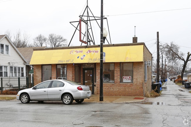
Property Record
10559 S Avenue M, Chicago, IL 60617

Current Lease Availabilities
Property Detail
10559 S Avenue M
26-08-328-022-0000
Cook
Commercialbuilding
Illinois
B3-1
26,25
B and X Area of moderate flood hazard, usually the area between the limits of the 100-year and 500-year floods.
0.06 AC
2023
South Chicago
2025
Chicago
520300
Chicago-Naperville-Elgin, IL-IN
1,346 SF
NEARBY LISTINGS FOR SALE OR LEASE
DEMOGRAPHICS near 10559 S Avenue M
1 mile
3 mile
5 mile
2025 Total Population
17,254
65,770
233,230
2030 Population
16,774
64,848
233,683
Pop Growth 2025-2030
(2.78%)
(1.40%)
+ 0.19%
Average Age
38
40
41
2025 Total Households
5,451
24,172
95,349
HH Growth 2025-2030
(3.06%)
(1.53%)
+ 0.04%
Median Household Inc
$63,953
$54,211
$46,957
Avg Household Size
3.00
2.60
2.40
2025 Avg HH Vehicles
2.00
1.00
1.00
Median Home Value
$173,367
$171,000
$181,057
Median Year Built
1947
1946
1947
Nearby Places
Map Layers
Map Styles
 Street
 Aerial
Layers
 Traffic
 Biking
Places
Listings with unknown addresses are not visible on the map
- Restaurants
- Banks
- Shops
- Fitness
- Groceries
PUBLIC TRANSPORTATION
COMMUTER RAIL
Hammond-Whiting Amtrak Station (Wolverine - Amtrak)
Drive
Walk
Distance
Hammond-Whiting Amtrak Station (Wolverine - Amtrak)
5 min
2.4 mi
South Chicago (93Rd Street) Station (Metra Electric Line - Northeast Illinois Regional Commuter Railroad (Metra))
Drive
Walk
Distance
South Chicago (93Rd Street) Station (Metra Electric Line - Northeast Illinois Regional Commuter Railroad (Metra))
6 min
2.6 mi
AIRPORT
Chicago Midway International
Drive
Walk
Distance
Chicago Midway International
28 min
15.7 mi
Chicago O'Hare International
Drive
Walk
Distance
Chicago O'Hare International
50 min
32.8 mi
Freight Ports
Port Milwaukee
Drive
Walk
Distance
Port Milwaukee
128 min
101.0 mi
Nearby Properties
Address
Land Use
TOTAL SIZE
Lot Size
Zoning
Address
Land Use
TOTAL SIZE
Lot Size
Zoning
282,089 SF
3.82 AC
R33
Address
Land Use
TOTAL SIZE
Lot Size
Zoning
41,400 SF
13.35 AC
PD 1254
Address
Land Use
TOTAL SIZE
Lot Size
Zoning
112,300 SF
2.34 AC
Address
Land Use
TOTAL SIZE
Lot Size
Zoning
196,210 SF
21.55 AC
Address
Land Use
TOTAL SIZE
Lot Size
Zoning
790,642 SF
37.20 AC
Address
Land Use
TOTAL SIZE
Lot Size
Zoning
8,400 SF
65.94 AC
PMD 6
Address
Land Use
TOTAL SIZE
Lot Size
Zoning
678,912 SF
29.68 AC
Address
Land Use
TOTAL SIZE
Lot Size
Zoning
55,357 SF
5.23 AC
Address
Land Use
TOTAL SIZE
Lot Size
Zoning
Address
Land Use
TOTAL SIZE
Lot Size
Zoning
46,056 SF
0.43 AC
Address
Land Use
TOTAL SIZE
Lot Size
Zoning
164,909 SF
14.28 AC
PD 248
Address
Land Use
TOTAL SIZE
Lot Size
Zoning
35,133 SF
0.20 AC
Address
Land Use
TOTAL SIZE
Lot Size
Zoning
547,200 SF
29.76 AC
PD 804
Address
Land Use
TOTAL SIZE
Lot Size
Zoning
361,023 SF
Address
Land Use
TOTAL SIZE
Lot Size
Zoning
9,680 SF
3.52 AC
Address
Land Use
TOTAL SIZE
Lot Size
Zoning
49,250 SF
7.62 AC
Address
Land Use
TOTAL SIZE
Lot Size
Zoning
10,370 SF
1.13 AC
Address
Land Use
TOTAL SIZE
Lot Size
Zoning
592 SF
8.81 AC
Address
Land Use
TOTAL SIZE
Lot Size
Zoning
17,360 SF
6.74 AC
Address
Land Use
TOTAL SIZE
Lot Size
Zoning
460,800 SF
20.63 AC
PD 804
Address
Land Use
TOTAL SIZE
Lot Size
Zoning
178,304 SF
8.98 AC
Address
Land Use
TOTAL SIZE
Lot Size
Zoning
607,000 SF
Address
Land Use
TOTAL SIZE
Lot Size
Zoning
387,750 SF
20.33 AC
PD 804
Address
Land Use
TOTAL SIZE
Lot Size
Zoning
12,334 SF
53.37 AC
PD 1160
Address
Land Use
TOTAL SIZE
Lot Size
Zoning
78,744 SF
5.07 AC
Address
Land Use
TOTAL SIZE
Lot Size
Zoning
6,047 SF
0.58 AC
Address
Land Use
TOTAL SIZE
Lot Size
Zoning
Address
Land Use
TOTAL SIZE
Lot Size
Zoning
542,852 SF
PMD 6,M2-1
Address
Land Use
TOTAL SIZE
Lot Size
Zoning
5,300 SF
36.84 AC
PMD 6
Address
Land Use
TOTAL SIZE
Lot Size
Zoning
30,240 SF
0.17 AC
B1-2
The World's #1 Commercial Real Estate Marketplace
Connect with us
© 2026 CoStar Group
The information above has been obtained from sources believed reliable. While we do not doubt its accuracy we have not verified it and make no guarantee, warranty or representation about it. It is your responsibility to independently confirm its accuracy and completeness. Any projections, opinions, assumptions, or estimates used are for example only and do not represent the current or future performance of the property. The value of this transaction to you depends on tax and other factors which should be evaluated by your tax, financial, and legal advisors. You and your advisors should conduct a careful, independent investigation of the property to determine to your satisfaction the suitability of the property for your needs.