Property Record
3545 Dam Neck Rd, Virginia Beach, VA 23453

NEARBY LISTINGS FOR SALE OR LEASE
Property Detail
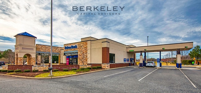
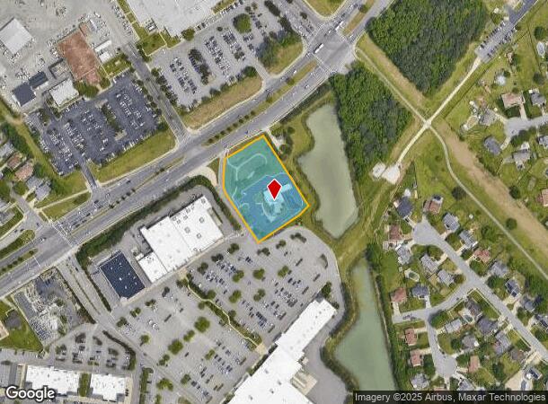
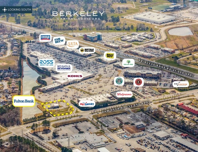
3545 Dam Neck Rd
1485-91-8632
Landstown Commons Retail Center
Regionalshoppingcenterormallwithanchorstore
LANDSTOWN COMMONS RETAIL CENTER PARCEL D-1 1.479 AC
X
Virginia Beach
5155310114F
Virginia
2024
1.48 AC
2025
VA Beach Courthouse
045422
Hampton Roads
3,458 SF
Virginia Beach-Norfolk-Newport News, VA-NC
DEMOGRAPHICS near 3545 Dam Neck Rd
1 Mile
3 Mile
5 Mile
2024 Total Population
5,538
84,640
195,946
2029 Population
5,449
83,660
193,480
Pop Growth 2024-2029
(1.61%)
(1.16%)
(1.26%)
Average Age
38
37
38
2024 Total Households
1,765
29,439
71,371
HH Growth 2024-2029
(1.81%)
(1.28%)
(1.38%)
Median Household Inc
$103,535
$87,457
$84,780
Avg Household Size
3.10
2.80
2.60
2024 Avg HH Vehicles
2.00
2.00
2.00
Median Home Value
$347,480
$285,434
$298,387
Median Year Built
1991
1986
1984
Nearby Places
Map Layers
Map Styles
 Street
 Aerial
- Restaurants
- Banks
- Shops
- Fitness
- Groceries
PUBLIC TRANSPORTATION
AIRPORT
Norfolk International
DRIVE
WALK
Distance
Norfolk International
25 min
15.1 mi
Freight Ports
Virginia Port Authority - Portsmouth
DRIVE
WALK
Distance
Virginia Port Authority - Portsmouth
33 min
18.1 mi
SALE & LEASE HISTORY
LISTING DATE
SALE/LEASE

Jul 23, 2020
For Sale
Aug 15, 2019
For Sale
Nearby Properties
Address
Land Use
TOTAL SIZE
Lot Size
Zoning
Address
Land Use
TOTAL SIZE
Lot Size
Zoning
2,088 SF
44 SF
AG1
Address
Land Use
TOTAL SIZE
Lot Size
Zoning
693,172 SF
O2
Address
Land Use
TOTAL SIZE
Lot Size
Zoning
100 SF
13.35 AC
B2
Address
Land Use
TOTAL SIZE
Lot Size
Zoning
675,493 SF
33.56 AC
AG1
Address
Land Use
TOTAL SIZE
Lot Size
Zoning
536,135 SF
115.04 AC
P1
Address
Land Use
TOTAL SIZE
Lot Size
Zoning
1 SF
44.31 AC
A18
Address
Land Use
TOTAL SIZE
Lot Size
Zoning
23.06 AC
A36
Address
Land Use
TOTAL SIZE
Lot Size
Zoning
356,343 SF
104.97 AC
Address
Land Use
TOTAL SIZE
Lot Size
Zoning
153 SF
88.33 AC
R75
Address
Land Use
TOTAL SIZE
Lot Size
Zoning
309,512 SF
65.15 AC
P1
Address
Land Use
TOTAL SIZE
Lot Size
Zoning
349,667 SF
35.30 AC
Address
Land Use
TOTAL SIZE
Lot Size
Zoning
3 SF
13.58 AC
A12
Address
Land Use
TOTAL SIZE
Lot Size
Zoning
287,520 SF
13.10 AC
A18
Address
Land Use
TOTAL SIZE
Lot Size
Zoning
15.68 AC
A18
Address
Land Use
TOTAL SIZE
Lot Size
Zoning
303,706 SF
13.62 AC
AG2
Address
Land Use
TOTAL SIZE
Lot Size
Zoning
409,152 SF
29.42 AC
I2
Address
Land Use
TOTAL SIZE
Lot Size
Zoning
289,581 SF
49.99 AC
R5D
Address
Land Use
TOTAL SIZE
Lot Size
Zoning
1 SF
18.64 AC
PDH1
Address
Land Use
TOTAL SIZE
Lot Size
Zoning
366,189 SF
55.78 AC
B2
Address
Land Use
TOTAL SIZE
Lot Size
Zoning
219,000 SF
75.18 AC
I1
Address
Land Use
TOTAL SIZE
Lot Size
Zoning
358,274 SF
30.64 AC
B2
Address
Land Use
TOTAL SIZE
Lot Size
Zoning
252,686 SF
50.05 AC
PDH1
Address
Land Use
TOTAL SIZE
Lot Size
Zoning
138,768 SF
26 AC
AG1
Address
Land Use
TOTAL SIZE
Lot Size
Zoning
174,868 SF
65.46 AC
AG1
Address
Land Use
TOTAL SIZE
Lot Size
Zoning
128,577 SF
15.28 AC
I1
Address
Land Use
TOTAL SIZE
Lot Size
Zoning
186,971 SF
23.87 AC
O2
Address
Land Use
TOTAL SIZE
Lot Size
Zoning
68,731 SF
5.80 AC
Address
Land Use
TOTAL SIZE
Lot Size
Zoning
1 SF
9.90 AC
PDH1
Address
Land Use
TOTAL SIZE
Lot Size
Zoning
86,174 SF
33.02 AC
R5D
Address
Land Use
TOTAL SIZE
Lot Size
Zoning
211,322 SF
40.10 AC
I1
The World's #1 Commercial Real Estate Marketplace
Connect with us
© 2025 CoStar Group
The information above has been obtained from sources believed reliable. While we do not doubt its accuracy we have not verified it and make no guarantee, warranty or representation about it. It is your responsibility to independently confirm its accuracy and completeness. Any projections, opinions, assumptions, or estimates used are for example only and do not represent the current or future performance of the property. The value of this transaction to you depends on tax and other factors which should be evaluated by your tax, financial, and legal advisors. You and your advisors should conduct a careful, independent investigation of the property to determine to your satisfaction the suitability of the property for your needs.