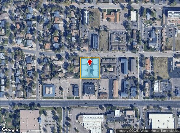
Property Record
3547 E Uintah St, Colorado Springs, CO 80909
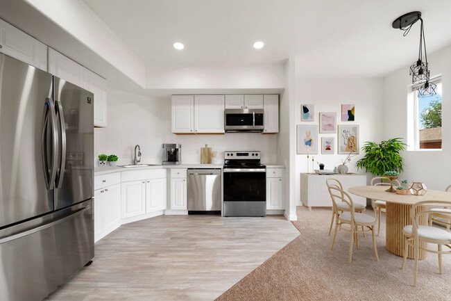
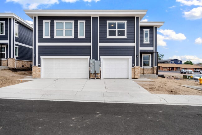
This Property Is For Sale
NEARBY LISTINGS FOR SALE OR LEASE
Property Detail
3547 E Uintah St
Colorado Springs, CO
Village On Uintah Sub Fil No 1
64101-18-037
LOT 2 VILLAGE ON UINTAH SUB FIL NO 1
Multifamilydwelling
El Paso
X
Colorado
08041C0732G
2
2024
0.99 AC
2025
Knob Hill
002000
Colorado Springs
19,746 SF
DEMOGRAPHICS near 3547 E Uintah St
1 Mile
3 Mile
5 Mile
2024 Total Population
14,974
121,830
282,086
2029 Population
15,574
127,476
294,543
Pop Growth 2024-2029
+ 4.01%
+ 4.63%
+ 4.42%
Average Age
38
38
38
2024 Total Households
6,281
51,521
115,005
HH Growth 2024-2029
+ 4.27%
+ 4.89%
+ 4.69%
Median Household Inc
$48,954
$55,698
$62,157
Avg Household Size
2.30
2.30
2.30
2024 Avg HH Vehicles
2.00
2.00
2.00
Median Home Value
$287,509
$316,746
$333,021
Median Year Built
1969
1973
1978
Nearby Places
Map Layers
Map Styles
 Street
 Aerial
- Restaurants
- Banks
- Shops
- Fitness
- Groceries
PUBLIC TRANSPORTATION
AIRPORT
City of Colorado Springs Municipal
DRIVE
WALK
Distance
City of Colorado Springs Municipal
14 min
6.2 mi
Nearby Properties
Address
Land Use
TOTAL SIZE
Lot Size
Zoning
Address
Land Use
TOTAL SIZE
Lot Size
Zoning
1,072,186 SF
15.14 AC
MX-N HR CU
Address
Land Use
TOTAL SIZE
Lot Size
Zoning
326,035 SF
33.75 AC
PCR UV
Address
Land Use
TOTAL SIZE
Lot Size
Zoning
229,081 SF
9.87 AC
MX-N CU SS
Address
Land Use
TOTAL SIZE
Lot Size
Zoning
200,642 SF
6.65 AC
MX-M HR AO
Address
Land Use
TOTAL SIZE
Lot Size
Zoning
167,120 SF
10.59 AC
MX-L/CR CU
Address
Land Use
TOTAL SIZE
Lot Size
Zoning
197,578 SF
7.98 AC
PDZ
Address
Land Use
TOTAL SIZE
Lot Size
Zoning
75,831 SF
3.37 AC
R-5 P
Address
Land Use
TOTAL SIZE
Lot Size
Zoning
131,545 SF
12.46 AC
R-5/CR CU
Address
Land Use
TOTAL SIZE
Lot Size
Zoning
138,773 SF
4.45 AC
R-5
Address
Land Use
TOTAL SIZE
Lot Size
Zoning
109,739 SF
18.61 AC
BP/CR CU
Address
Land Use
TOTAL SIZE
Lot Size
Zoning
113,594 SF
1.65 AC
R-5 HR
Address
Land Use
TOTAL SIZE
Lot Size
Zoning
83,441 SF
4.20 AC
MX-M/CR CU
Address
Land Use
TOTAL SIZE
Lot Size
Zoning
1,223 SF
725.94 AC
PF PK SS
Address
Land Use
TOTAL SIZE
Lot Size
Zoning
65,400 SF
13.65 AC
PF CU
Address
Land Use
TOTAL SIZE
Lot Size
Zoning
86,290 SF
8.01 AC
I-2 CAD-O
Address
Land Use
TOTAL SIZE
Lot Size
Zoning
98,638 SF
7.22 AC
MX-M AO
Address
Land Use
TOTAL SIZE
Lot Size
Zoning
75,958 SF
0.96 AC
PK R-5 HR
Address
Land Use
TOTAL SIZE
Lot Size
Zoning
152,517 SF
12.17 AC
MX-L
Address
Land Use
TOTAL SIZE
Lot Size
Zoning
23,535 SF
15.91 AC
BP/CR AO
Address
Land Use
TOTAL SIZE
Lot Size
Zoning
39,627 SF
1.61 AC
R-5 SS
Address
Land Use
TOTAL SIZE
Lot Size
Zoning
226,448 SF
16.80 AC
MX-N/CR
Address
Land Use
TOTAL SIZE
Lot Size
Zoning
76,203 SF
8.15 AC
PF
Address
Land Use
TOTAL SIZE
Lot Size
Zoning
55,432 SF
4.78 AC
R-5
Address
Land Use
TOTAL SIZE
Lot Size
Zoning
45,044 SF
2 AC
R-1 6
Address
Land Use
TOTAL SIZE
Lot Size
Zoning
60,324 SF
1.72 AC
R-5
Address
Land Use
TOTAL SIZE
Lot Size
Zoning
48,117 SF
2.96 AC
MX-M CU
Address
Land Use
TOTAL SIZE
Lot Size
Zoning
104,162 SF
20.14 AC
R-1 6
Address
Land Use
TOTAL SIZE
Lot Size
Zoning
55,821 SF
2.13 AC
MX-N/CR
Address
Land Use
TOTAL SIZE
Lot Size
Zoning
92,568 SF
11.08 AC
MX-M/CR
Address
Land Use
TOTAL SIZE
Lot Size
Zoning
45,328 SF
3.87 AC
R-4 CAD-O
The World's #1 Commercial Real Estate Marketplace
Connect with us
© 2025 CoStar Group
The information above has been obtained from sources believed reliable. While we do not doubt its accuracy we have not verified it and make no guarantee, warranty or representation about it. It is your responsibility to independently confirm its accuracy and completeness. Any projections, opinions, assumptions, or estimates used are for example only and do not represent the current or future performance of the property. The value of this transaction to you depends on tax and other factors which should be evaluated by your tax, financial, and legal advisors. You and your advisors should conduct a careful, independent investigation of the property to determine to your satisfaction the suitability of the property for your needs.