Property Record
3547 E Carters Valley Rd, Gate City, VA 24251

Property Detail
3547 E Carters Valley Rd
Kingsport-Bristol, TN-VA
HOLSTON RIVER 289/742
169-A-10
SCOTT
Ruralimprovednonresidential
Virginia
A Areas with a 1% annual chance of flooding and a 26% chance of flooding over the life of a 30-year mortgage.
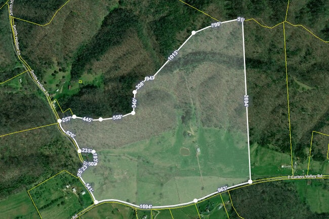
146.30 AC
2025
Scott County
2025
Kingsport/Bristol/Bristol
030100
NEARBY LISTINGS FOR SALE OR LEASE
-
-
View all Gate City listings for sale on LoopNet.com
DEMOGRAPHICS near 3547 E Carters Valley Rd
1 mile
3 mile
5 mile
2025 Total Population
85
9,773
37,390
2030 Population
84
9,991
38,314
Pop Growth 2025-2030
(1.18%)
+ 2.23%
+ 2.47%
Average Age
45
45
44
2025 Total Households
37
4,212
16,369
HH Growth 2025-2030
0.00%
+ 2.23%
+ 2.51%
Median Household Inc
$56,666
$50,795
$49,356
Avg Household Size
2.20
2.30
2.20
2025 Avg HH Vehicles
2.00
2.00
2.00
Median Home Value
$194,444
$168,603
$183,381
Median Year Built
1973
1973
1970
Nearby Places
Map Layers
Map Styles
 Street
 Aerial
Layers
 Traffic
 Biking
Places
Listings with unknown addresses are not visible on the map
- Restaurants
- Banks
- Shops
- Fitness
- Groceries
PUBLIC TRANSPORTATION
AIRPORT
Tri-Cities
Drive
Walk
Distance
Tri-Cities
26 min
18.5 mi
Freight Ports
Virginia Port Authority - Richmond
Drive
Walk
Distance
Virginia Port Authority - Richmond
396 min
351.3 mi
SALE & LEASE HISTORY
LISTING DATE
SALE/LEASE

Apr 07, 2020
For Sale
Nearby Properties
Address
Land Use
TOTAL SIZE
Lot Size
Zoning
Address
Land Use
TOTAL SIZE
Lot Size
Zoning
42,091 SF
0.76 AC
Address
Land Use
TOTAL SIZE
Lot Size
Zoning
47,412 SF
5.49 AC
Address
Land Use
TOTAL SIZE
Lot Size
Zoning
18,290 SF
1.11 AC
R3A
Address
Land Use
TOTAL SIZE
Lot Size
Zoning
12,760 SF
4.09 AC
B3
Address
Land Use
TOTAL SIZE
Lot Size
Zoning
15,036 SF
0.76 AC
Address
Land Use
TOTAL SIZE
Lot Size
Zoning
9,565 SF
5 AC
R1
Address
Land Use
TOTAL SIZE
Lot Size
Zoning
10,508 SF
4.18 AC
R1
Address
Land Use
TOTAL SIZE
Lot Size
Zoning
24,000 SF
0.33 AC
Address
Land Use
TOTAL SIZE
Lot Size
Zoning
720 SF
2 AC
Address
Land Use
TOTAL SIZE
Lot Size
Zoning
40,609 SF
4.17 AC
B3
Address
Land Use
TOTAL SIZE
Lot Size
Zoning
17,844 SF
2.30 AC
R1
Address
Land Use
TOTAL SIZE
Lot Size
Zoning
6,196 SF
2.15 AC
Address
Land Use
TOTAL SIZE
Lot Size
Zoning
4,800 SF
9.92 AC
Address
Land Use
TOTAL SIZE
Lot Size
Zoning
221 SF
127.35 AC
Address
Land Use
TOTAL SIZE
Lot Size
Zoning
3,080 SF
0.78 AC
Address
Land Use
TOTAL SIZE
Lot Size
Zoning
2,090 SF
1.92 AC
Address
Land Use
TOTAL SIZE
Lot Size
Zoning
92,500 SF
12 AC
Address
Land Use
TOTAL SIZE
Lot Size
Zoning
5,256 SF
2.02 AC
Address
Land Use
TOTAL SIZE
Lot Size
Zoning
4,418 SF
0.35 AC
Address
Land Use
TOTAL SIZE
Lot Size
Zoning
175 SF
83.92 AC
Address
Land Use
TOTAL SIZE
Lot Size
Zoning
2,453 SF
0.50 AC
Address
Land Use
TOTAL SIZE
Lot Size
Zoning
3,399 SF
32.38 AC
M2
Address
Land Use
TOTAL SIZE
Lot Size
Zoning
28,280 SF
9.56 AC
B3
Address
Land Use
TOTAL SIZE
Lot Size
Zoning
9,472 SF
0.72 AC
R1
Address
Land Use
TOTAL SIZE
Lot Size
Zoning
2,201 SF
0.25 AC
Address
Land Use
TOTAL SIZE
Lot Size
Zoning
8,481 SF
0.69 AC
R2A
Address
Land Use
TOTAL SIZE
Lot Size
Zoning
1,800 SF
0.50 AC
Address
Land Use
TOTAL SIZE
Lot Size
Zoning
Address
Land Use
TOTAL SIZE
Lot Size
Zoning
5,450 SF
0.60 AC
Address
Land Use
TOTAL SIZE
Lot Size
Zoning
6,476 SF
0.50 AC
R1
The World's #1 Commercial Real Estate Marketplace
Connect with us
© 2026 CoStar Group
The information above has been obtained from sources believed reliable. While we do not doubt its accuracy we have not verified it and make no guarantee, warranty or representation about it. It is your responsibility to independently confirm its accuracy and completeness. Any projections, opinions, assumptions, or estimates used are for example only and do not represent the current or future performance of the property. The value of this transaction to you depends on tax and other factors which should be evaluated by your tax, financial, and legal advisors. You and your advisors should conduct a careful, independent investigation of the property to determine to your satisfaction the suitability of the property for your needs.