Property Record
3548 Heathrow Way, Medford, OR 97504


NEARBY LISTINGS FOR SALE OR LEASE
-
-
View all Medford listings for sale on LoopNet.com
Property Detail
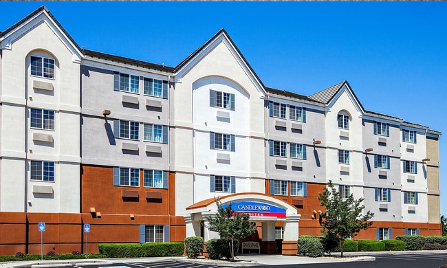
3548 Heathrow Way
10972048
Navigators Landing
Commercialbuilding
Jackson
A
Oregon
41029C1957F
39
2024
1.66 AC
2025
Medford/Grants Pass
001200
Other Market Areas
39,492 SF
Medford, OR
DEMOGRAPHICS near 3548 Heathrow Way
1 Mile
3 Mile
5 Mile
2024 Total Population
4,143
64,476
114,795
2029 Population
4,094
64,289
114,224
Pop Growth 2024-2029
(1.18%)
(0.29%)
(0.50%)
Average Age
38
40
41
2024 Total Households
1,488
25,038
44,551
HH Growth 2024-2029
(1.21%)
(0.33%)
(0.55%)
Median Household Inc
$79,200
$61,917
$65,241
Avg Household Size
2.70
2.50
2.50
2024 Avg HH Vehicles
2.00
2.00
2.00
Median Home Value
$268,200
$318,461
$339,255
Median Year Built
1992
1984
1983
Nearby Places
Map Layers
Map Styles
 Street
 Aerial
- Restaurants
- Banks
- Shops
- Fitness
- Groceries
PUBLIC TRANSPORTATION
AIRPORT
Rogue Valley International - Medford
DRIVE
WALK
Distance
Rogue Valley International - Medford
3 min
0.7 mi
SALE & LEASE HISTORY
LISTING DATE
SALE/LEASE

Sep 23, 2016
For Sale
Jan 20, 2020
For Sale
Nearby Properties
Address
Land Use
TOTAL SIZE
Lot Size
Zoning
Address
Land Use
TOTAL SIZE
Lot Size
Zoning
290.83 AC
I-L
Address
Land Use
TOTAL SIZE
Lot Size
Zoning
249,867 SF
61.31 AC
SFR-4
Address
Land Use
TOTAL SIZE
Lot Size
Zoning
22.07 AC
GI
Address
Land Use
TOTAL SIZE
Lot Size
Zoning
600,000 SF
18.27 AC
M-1
Address
Land Use
TOTAL SIZE
Lot Size
Zoning
77,354 SF
8.28 AC
SFR-4
Address
Land Use
TOTAL SIZE
Lot Size
Zoning
31.96 AC
GI
Address
Land Use
TOTAL SIZE
Lot Size
Zoning
177,106 SF
16.28 AC
C-C
Address
Land Use
TOTAL SIZE
Lot Size
Zoning
11,180 SF
1.58 AC
MFR-20
Address
Land Use
TOTAL SIZE
Lot Size
Zoning
531,599 SF
26.34 AC
C-R
Address
Land Use
TOTAL SIZE
Lot Size
Zoning
176,910 SF
17.78 AC
C-R
Address
Land Use
TOTAL SIZE
Lot Size
Zoning
2,762 SF
6.81 AC
C-S/P
Address
Land Use
TOTAL SIZE
Lot Size
Zoning
43.71 AC
GI
Address
Land Use
TOTAL SIZE
Lot Size
Zoning
1,126 SF
4.89 AC
SFR-4
Address
Land Use
TOTAL SIZE
Lot Size
Zoning
13.49 AC
M-1
Address
Land Use
TOTAL SIZE
Lot Size
Zoning
88,434 SF
12.10 AC
I-L
Address
Land Use
TOTAL SIZE
Lot Size
Zoning
30.87 AC
CIVIC
Address
Land Use
TOTAL SIZE
Lot Size
Zoning
3.54 AC
MFR-20
Address
Land Use
TOTAL SIZE
Lot Size
Zoning
88.67 AC
I-L
Address
Land Use
TOTAL SIZE
Lot Size
Zoning
6,140 SF
0.84 AC
C-C
Address
Land Use
TOTAL SIZE
Lot Size
Zoning
125,910 SF
14.29 AC
C-R
Address
Land Use
TOTAL SIZE
Lot Size
Zoning
136,756 SF
12.50 AC
C-R
Address
Land Use
TOTAL SIZE
Lot Size
Zoning
1,680 SF
43.61 AC
GI
Address
Land Use
TOTAL SIZE
Lot Size
Zoning
109,042 SF
7.06 AC
C-R
Address
Land Use
TOTAL SIZE
Lot Size
Zoning
6,039 SF
5.26 AC
MMR
Address
Land Use
TOTAL SIZE
Lot Size
Zoning
245,754 SF
5.33 AC
MFR-30
Address
Land Use
TOTAL SIZE
Lot Size
Zoning
77,232 SF
1.46 AC
MFR-20
Address
Land Use
TOTAL SIZE
Lot Size
Zoning
46,774 SF
4.29 AC
SFR-6
Address
Land Use
TOTAL SIZE
Lot Size
Zoning
15.97 AC
GI
Address
Land Use
TOTAL SIZE
Lot Size
Zoning
31,283 SF
2.95 AC
I-L
Address
Land Use
TOTAL SIZE
Lot Size
Zoning
116,000 SF
5.17 AC
MFR-30
The World's #1 Commercial Real Estate Marketplace
Connect with us
© 2025 CoStar Group
The information above has been obtained from sources believed reliable. While we do not doubt its accuracy we have not verified it and make no guarantee, warranty or representation about it. It is your responsibility to independently confirm its accuracy and completeness. Any projections, opinions, assumptions, or estimates used are for example only and do not represent the current or future performance of the property. The value of this transaction to you depends on tax and other factors which should be evaluated by your tax, financial, and legal advisors. You and your advisors should conduct a careful, independent investigation of the property to determine to your satisfaction the suitability of the property for your needs.