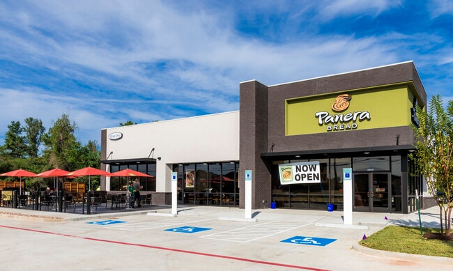
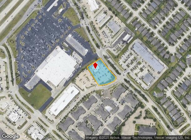
Property Record
3548 Rayford Rd, Spring, TX 77386

NEARBY LISTINGS FOR SALE OR LEASE
Property Detail
3548 Rayford Rd
0351-01-01045
Montg Co Sch Land
Commercialnec
A0351 - MONTG CO SCH LAND, TRACT 10H6A-1 (AKA HARMONY RPM4M CENTRAL PARTIAL REPLAT NO 1 FILE NO 2014125411), ACRES 1.17
X
Montgomery
48339C0685G
Texas
2024
1.17 AC
2025
Montgomery County
692009
Houston
4,400 SF
Houston-Pasadena-The Woodlands, TX
DEMOGRAPHICS near 3548 Rayford Rd
1 mile
3 mile
5 mile
2024 Total Population
15,070
74,652
161,980
2029 Population
18,303
87,962
184,813
Pop Growth 2024-2029
+ 21.45%
+ 17.83%
+ 14.10%
Average Age
33
34
35
2024 Total Households
4,907
24,055
54,762
HH Growth 2024-2029
+ 21.58%
+ 17.57%
+ 13.99%
Median Household Inc
$124,215
$116,816
$93,474
Avg Household Size
3.10
3.10
2.90
2024 Avg HH Vehicles
2.00
2.00
2.00
Median Home Value
$285,332
$282,985
$251,322
Median Year Built
2009
2007
2003
Nearby Places
Map Layers
Map Styles
 Street
 Aerial
Transit
 Traffic
 Biking
Places
Listings with unknown addresses are not visible on the map
- Restaurants
- Banks
- Shops
- Fitness
- Groceries
PUBLIC TRANSPORTATION
AIRPORT
George Bush Intcntl/Houston
Drive
Walk
Distance
George Bush Intcntl/Houston
23 min
17.6 mi
Freight Ports
Port of Houston
Drive
Walk
Distance
Port of Houston
46 min
33.3 mi
SALE & LEASE HISTORY
LISTING DATE
SALE/LEASE

Oct 29, 2025
For Lease
Oct 29, 2025
For Sale
Jan 12, 2017
For Sale
Nearby Properties
Address
Land Use
TOTAL SIZE
Lot Size
Zoning
Address
Land Use
TOTAL SIZE
Lot Size
Zoning
354,981 SF
72.09 AC
Address
Land Use
TOTAL SIZE
Lot Size
Zoning
970,101 SF
48.05 AC
Address
Land Use
TOTAL SIZE
Lot Size
Zoning
296,094 SF
10.19 AC
Address
Land Use
TOTAL SIZE
Lot Size
Zoning
153,729 SF
17.94 AC
Address
Land Use
TOTAL SIZE
Lot Size
Zoning
471,015 SF
6.63 AC
Address
Land Use
TOTAL SIZE
Lot Size
Zoning
397,984 SF
6.42 AC
Address
Land Use
TOTAL SIZE
Lot Size
Zoning
331,264 SF
12.92 AC
Address
Land Use
TOTAL SIZE
Lot Size
Zoning
321,024 SF
8.73 AC
6
Address
Land Use
TOTAL SIZE
Lot Size
Zoning
201,182 SF
10.55 AC
Address
Land Use
TOTAL SIZE
Lot Size
Zoning
216,833 SF
15.97 AC
Address
Land Use
TOTAL SIZE
Lot Size
Zoning
215,741 SF
14 AC
Address
Land Use
TOTAL SIZE
Lot Size
Zoning
196,000 SF
19.44 AC
Address
Land Use
TOTAL SIZE
Lot Size
Zoning
179,426 SF
5.70 AC
Address
Land Use
TOTAL SIZE
Lot Size
Zoning
89,090 SF
10.93 AC
Address
Land Use
TOTAL SIZE
Lot Size
Zoning
294,256 SF
18.49 AC
6
Address
Land Use
TOTAL SIZE
Lot Size
Zoning
184,338 SF
17.13 AC
Address
Land Use
TOTAL SIZE
Lot Size
Zoning
122,925 SF
16.68 AC
Address
Land Use
TOTAL SIZE
Lot Size
Zoning
152,898 SF
17 AC
Address
Land Use
TOTAL SIZE
Lot Size
Zoning
91,128 SF
2.90 AC
Address
Land Use
TOTAL SIZE
Lot Size
Zoning
138,536 SF
15.99 AC
Address
Land Use
TOTAL SIZE
Lot Size
Zoning
120,807 SF
12.62 AC
Address
Land Use
TOTAL SIZE
Lot Size
Zoning
200,000 SF
23.54 AC
Address
Land Use
TOTAL SIZE
Lot Size
Zoning
126,509 SF
15.59 AC
Address
Land Use
TOTAL SIZE
Lot Size
Zoning
63,988 SF
2.56 AC
Address
Land Use
TOTAL SIZE
Lot Size
Zoning
122,200 SF
5.71 AC
6
Address
Land Use
TOTAL SIZE
Lot Size
Zoning
133,188 SF
2.26 AC
6
Address
Land Use
TOTAL SIZE
Lot Size
Zoning
77,056 SF
2.70 AC
Address
Land Use
TOTAL SIZE
Lot Size
Zoning
135,960 SF
1.77 AC
Address
Land Use
TOTAL SIZE
Lot Size
Zoning
141,900 SF
10.26 AC
Address
Land Use
TOTAL SIZE
Lot Size
Zoning
88,428 SF
3.22 AC
The World's #1 Commercial Real Estate Marketplace
Connect with us
© 2026 CoStar Group
The information above has been obtained from sources believed reliable. While we do not doubt its accuracy we have not verified it and make no guarantee, warranty or representation about it. It is your responsibility to independently confirm its accuracy and completeness. Any projections, opinions, assumptions, or estimates used are for example only and do not represent the current or future performance of the property. The value of this transaction to you depends on tax and other factors which should be evaluated by your tax, financial, and legal advisors. You and your advisors should conduct a careful, independent investigation of the property to determine to your satisfaction the suitability of the property for your needs.