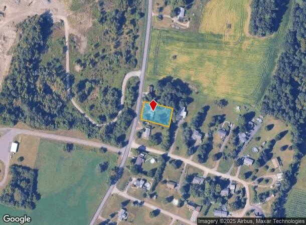
Property Record
355 County Route 19, Hudson, NY 12534
NEARBY LISTINGS FOR SALE OR LEASE
-
-
View all Hudson listings for sale on LoopNet.com
Property Detail
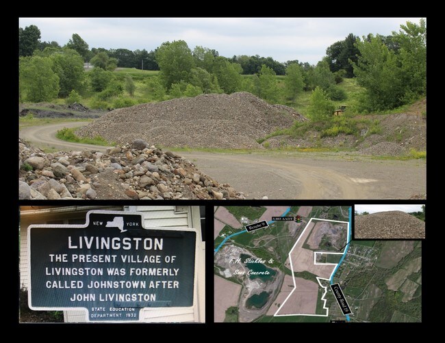
355 County Route 19
Albany/Schenectady/Troy
Columbia
Hudson, NY
New York
104600-171-000-0001-002-000-0000
0.43 AC
Sfr
Columbia County
864 SF
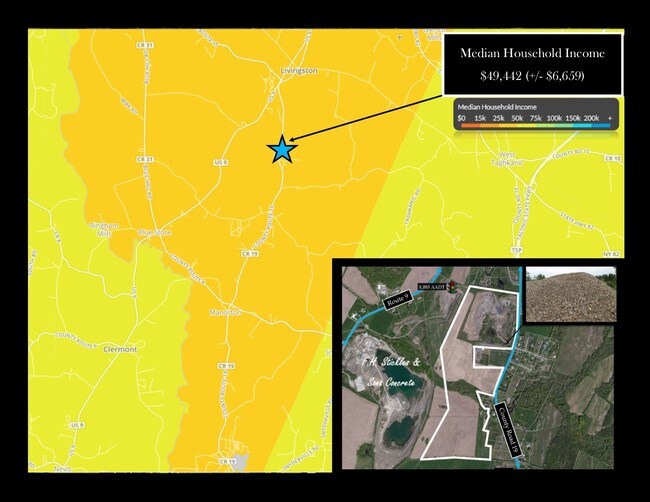
DEMOGRAPHICS near 355 County Route 19
1 Mile
3 Mile
5 Mile
2024 Total Population
310
2,118
6,757
2029 Population
301
2,080
6,682
Pop Growth 2024-2029
(2.90%)
(1.79%)
(1.11%)
Average Age
46
46
46
2024 Total Households
121
860
2,879
HH Growth 2024-2029
(3.31%)
(1.86%)
(1.11%)
Median Household Inc
$62,812
$69,374
$76,522
Avg Household Size
2.30
2.30
2.30
2024 Avg HH Vehicles
2.00
2.00
2.00
Median Home Value
$277,777
$299,999
$328,255
Median Year Built
1959
1967
1968
Nearby Places
Map Layers
Map Styles
 Street
 Aerial
- Restaurants
- Banks
- Shops
- Fitness
- Groceries
SALE & LEASE HISTORY
LISTING DATE
SALE/LEASE

Mar 27, 2017
For Sale
Nearby Properties
Address
Land Use
TOTAL SIZE
Lot Size
Zoning
Address
Land Use
TOTAL SIZE
Lot Size
Zoning
13,604 SF
91.70 AC
07 - MIXED
Address
Land Use
TOTAL SIZE
Lot Size
Zoning
980 SF
11.10 AC
07 - MIXED
Address
Land Use
TOTAL SIZE
Lot Size
Zoning
980 SF
16.95 AC
07 - MIXED
Address
Land Use
TOTAL SIZE
Lot Size
Zoning
780 SF
9 AC
07 - MIXED
Address
Land Use
TOTAL SIZE
Lot Size
Zoning
56.95 AC
07 - MIXED
Address
Land Use
TOTAL SIZE
Lot Size
Zoning
46,860 SF
14.07 AC
07 - MIXED
Address
Land Use
TOTAL SIZE
Lot Size
Zoning
51,448 SF
10.60 AC
07 - MIXED
Address
Land Use
TOTAL SIZE
Lot Size
Zoning
4,800 SF
7.01 AC
07 - MIXED
Address
Land Use
TOTAL SIZE
Lot Size
Zoning
7,910 SF
2.01 AC
07 - MIXED
Address
Land Use
TOTAL SIZE
Lot Size
Zoning
7,650 SF
0.62 AC
07 - MIXED
Address
Land Use
TOTAL SIZE
Lot Size
Zoning
316.68 AC
07 - MIXED
Address
Land Use
TOTAL SIZE
Lot Size
Zoning
65.40 AC
07 - MIXED
Address
Land Use
TOTAL SIZE
Lot Size
Zoning
1,344 SF
20.01 AC
07 - MIXED
Address
Land Use
TOTAL SIZE
Lot Size
Zoning
4,676 SF
1.29 AC
07 - MIXED
Address
Land Use
TOTAL SIZE
Lot Size
Zoning
233 AC
07 - MIXED
Address
Land Use
TOTAL SIZE
Lot Size
Zoning
40 AC
07 - MIXED
Address
Land Use
TOTAL SIZE
Lot Size
Zoning
209.54 AC
07 - MIXED
Address
Land Use
TOTAL SIZE
Lot Size
Zoning
18,570 SF
5 AC
07 - MIXED
Address
Land Use
TOTAL SIZE
Lot Size
Zoning
9,600 SF
36.08 AC
07 - MIXED
Address
Land Use
TOTAL SIZE
Lot Size
Zoning
133.83 AC
07 - MIXED
Address
Land Use
TOTAL SIZE
Lot Size
Zoning
1,128 SF
70.61 AC
07 - MIXED
Address
Land Use
TOTAL SIZE
Lot Size
Zoning
168.50 AC
07 - MIXED
Address
Land Use
TOTAL SIZE
Lot Size
Zoning
95.76 AC
07 - MIXED
Address
Land Use
TOTAL SIZE
Lot Size
Zoning
3,900 SF
158 AC
07 - MIXED
Address
Land Use
TOTAL SIZE
Lot Size
Zoning
137.03 AC
07
Address
Land Use
TOTAL SIZE
Lot Size
Zoning
41.37 AC
07 - MIXED
Address
Land Use
TOTAL SIZE
Lot Size
Zoning
1,908 SF
20.40 AC
07 - MIXED
Address
Land Use
TOTAL SIZE
Lot Size
Zoning
8,016 SF
22.64 AC
07 - MIXED
Address
Land Use
TOTAL SIZE
Lot Size
Zoning
8,544 SF
2.01 AC
07 - MIXED
Address
Land Use
TOTAL SIZE
Lot Size
Zoning
1,620 SF
0.39 AC
07 - MIXED
The World's #1 Commercial Real Estate Marketplace
Connect with us
© 2025 CoStar Group
The information above has been obtained from sources believed reliable. While we do not doubt its accuracy we have not verified it and make no guarantee, warranty or representation about it. It is your responsibility to independently confirm its accuracy and completeness. Any projections, opinions, assumptions, or estimates used are for example only and do not represent the current or future performance of the property. The value of this transaction to you depends on tax and other factors which should be evaluated by your tax, financial, and legal advisors. You and your advisors should conduct a careful, independent investigation of the property to determine to your satisfaction the suitability of the property for your needs.