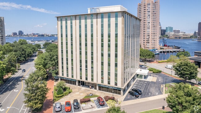
Property Record
355 Crawford St, Portsmouth, VA 23704
Current Lease Availabilities
NEARBY LISTINGS FOR SALE OR LEASE
Property Detail
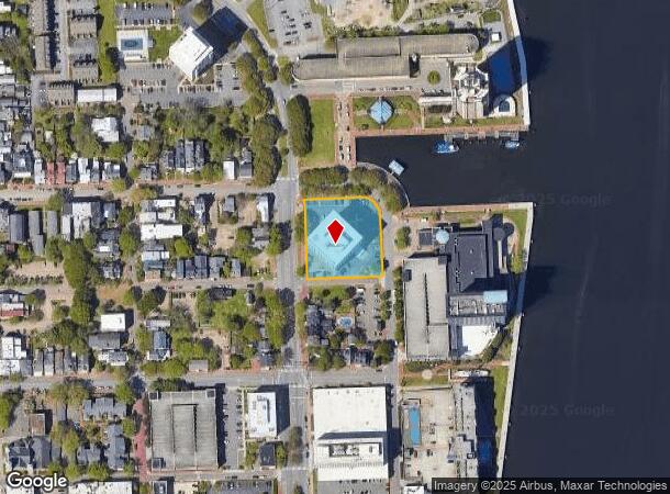
355 Crawford St
0004-0024
Commercial District 2
Officebuilding
1.118 AC NE CORN CRAWF & GLASGOW ST
AE
Portsmouth
5101040058H
Virginia
2024
1.12 AC
2025
Downtown Portsmouth
210900
Hampton Roads
96,800 SF
Virginia Beach-Norfolk-Newport News, VA-NC
DEMOGRAPHICS near 355 Crawford St
1 Mile
3 Mile
5 Mile
2024 Total Population
10,373
110,433
251,758
2029 Population
10,210
110,394
251,321
Pop Growth 2024-2029
(1.57%)
(0.04%)
(0.17%)
Average Age
39
36
37
2024 Total Households
5,515
45,274
101,152
HH Growth 2024-2029
(1.76%)
(0.39%)
(0.40%)
Median Household Inc
$60,107
$48,543
$57,335
Avg Household Size
1.80
2.30
2.30
2024 Avg HH Vehicles
1.00
1.00
2.00
Median Home Value
$255,058
$206,735
$220,846
Median Year Built
1977
1963
1965
Nearby Places
Map Layers
Map Styles
 Street
 Aerial
- Restaurants
- Banks
- Shops
- Fitness
- Groceries
PUBLIC TRANSPORTATION
COMMUTER RAIL
DRIVE
WALK
Distance
8 min
3.3 mi
AIRPORT
Norfolk International
DRIVE
WALK
Distance
Norfolk International
20 min
9.7 mi
Newport News/Williamsburg International
DRIVE
WALK
Distance
Newport News/Williamsburg International
47 min
32.9 mi
Nearby Properties
Address
Land Use
TOTAL SIZE
Lot Size
Zoning
Address
Land Use
TOTAL SIZE
Lot Size
Zoning
331,760 SF
24.97 AC
Address
Land Use
TOTAL SIZE
Lot Size
Zoning
5,704 SF
4.67 AC
D2
Address
Land Use
TOTAL SIZE
Lot Size
Zoning
85,756 SF
3.59 AC
D5
Address
Land Use
TOTAL SIZE
Lot Size
Zoning
421,540 SF
2.37 AC
Address
Land Use
TOTAL SIZE
Lot Size
Zoning
192,422 SF
10.70 AC
D4
Address
Land Use
TOTAL SIZE
Lot Size
Zoning
250,766 SF
31.14 AC
NMU
Address
Land Use
TOTAL SIZE
Lot Size
Zoning
390,960 SF
4.43 AC
Address
Land Use
TOTAL SIZE
Lot Size
Zoning
73,136 SF
5.34 AC
IN2
Address
Land Use
TOTAL SIZE
Lot Size
Zoning
55.11 AC
IN2
Address
Land Use
TOTAL SIZE
Lot Size
Zoning
92.17 AC
OSP
Address
Land Use
TOTAL SIZE
Lot Size
Zoning
421,856 SF
2.64 AC
D1
Address
Land Use
TOTAL SIZE
Lot Size
Zoning
971,654 SF
6.01 AC
D2
Address
Land Use
TOTAL SIZE
Lot Size
Zoning
310,912 SF
3.94 AC
Address
Land Use
TOTAL SIZE
Lot Size
Zoning
689,954 SF
63.25 AC
Address
Land Use
TOTAL SIZE
Lot Size
Zoning
473,072 SF
9.72 AC
SD
Address
Land Use
TOTAL SIZE
Lot Size
Zoning
258,000 SF
1.38 AC
M2: GENERA
Address
Land Use
TOTAL SIZE
Lot Size
Zoning
192,270 SF
1.99 AC
D2
Address
Land Use
TOTAL SIZE
Lot Size
Zoning
363,974 SF
1.49 AC
Address
Land Use
TOTAL SIZE
Lot Size
Zoning
66,718 SF
4.09 AC
D5
Address
Land Use
TOTAL SIZE
Lot Size
Zoning
4.92 AC
IN1
Address
Land Use
TOTAL SIZE
Lot Size
Zoning
356,598 SF
1.84 AC
D2
Address
Land Use
TOTAL SIZE
Lot Size
Zoning
50,384 SF
0.74 AC
Address
Land Use
TOTAL SIZE
Lot Size
Zoning
291,748 SF
3.40 AC
G1
Address
Land Use
TOTAL SIZE
Lot Size
Zoning
252,524 SF
20 AC
R8S: RESID
Address
Land Use
TOTAL SIZE
Lot Size
Zoning
406,344 SF
8.45 AC
GMU
Address
Land Use
TOTAL SIZE
Lot Size
Zoning
79,577 SF
3.04 AC
C2
Address
Land Use
TOTAL SIZE
Lot Size
Zoning
35,091 SF
0.71 AC
Address
Land Use
TOTAL SIZE
Lot Size
Zoning
197,074 SF
6.69 AC
Address
Land Use
TOTAL SIZE
Lot Size
Zoning
640,920 SF
3.67 AC
HCEF
Address
Land Use
TOTAL SIZE
Lot Size
Zoning
188,152 SF
16.93 AC
The World's #1 Commercial Real Estate Marketplace
Connect with us
© 2026 CoStar Group
The information above has been obtained from sources believed reliable. While we do not doubt its accuracy we have not verified it and make no guarantee, warranty or representation about it. It is your responsibility to independently confirm its accuracy and completeness. Any projections, opinions, assumptions, or estimates used are for example only and do not represent the current or future performance of the property. The value of this transaction to you depends on tax and other factors which should be evaluated by your tax, financial, and legal advisors. You and your advisors should conduct a careful, independent investigation of the property to determine to your satisfaction the suitability of the property for your needs.