Property Record
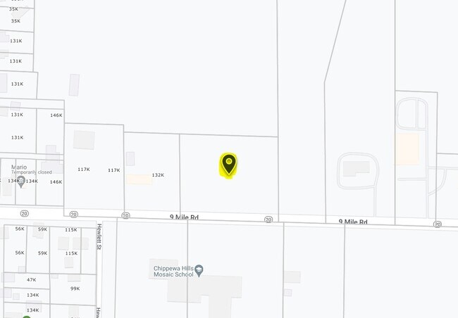
355 E Wheatland Ave, Remus, MI 49340

Property Detail
355 E Wheatland Ave
Big Rapids, MI
SEC 15 T14N R07W BEG AT SE COR SW 1/4 SW 1/4 TH N 88 DEG 37 M W 326.65 FT TH N 0 DEG 26 M W 278.98 FT TH S 88 DEG 27 M E 326.
5412-015-029-501
Mecosta
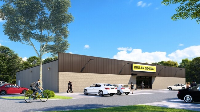
Commercialnec
Michigan
B and X Area of moderate flood hazard, usually the area between the limits of the 100-year and 500-year floods.
2.10 AC
2024
Michigan North Central Area
2025
Other Market Areas
960100
NEARBY LISTINGS FOR SALE OR LEASE
DEMOGRAPHICS near 355 E Wheatland Ave
1 mile
3 mile
5 mile
2025 Total Population
400
850
2,456
2030 Population
399
845
2,440
Pop Growth 2025-2030
(0.25%)
(0.59%)
(0.65%)
Average Age
47
46
44
2025 Total Households
174
361
991
HH Growth 2025-2030
0.00%
(0.28%)
(0.50%)
Median Household Inc
$70,908
$68,809
$65,480
Avg Household Size
2.30
2.30
2.40
2025 Avg HH Vehicles
2.00
2.00
2.00
Median Home Value
$243,965
$222,330
$192,762
Median Year Built
1984
1983
1983
Nearby Places
Map Layers
Map Styles
 Street
 Aerial
Layers
 Traffic
 Biking
Places
Listings with unknown addresses are not visible on the map
- Restaurants
- Banks
- Shops
- Fitness
- Groceries
SALE & LEASE HISTORY
LISTING DATE
SALE/LEASE

Jan 10, 2022
For Sale
Nearby Properties
Address
Land Use
TOTAL SIZE
Lot Size
Zoning
Address
Land Use
TOTAL SIZE
Lot Size
Zoning
11.14 AC
Address
Land Use
TOTAL SIZE
Lot Size
Zoning
Address
Land Use
TOTAL SIZE
Lot Size
Zoning
Address
Land Use
TOTAL SIZE
Lot Size
Zoning
9.92 AC
Address
Land Use
TOTAL SIZE
Lot Size
Zoning
4.39 AC
Address
Land Use
TOTAL SIZE
Lot Size
Zoning
Address
Land Use
TOTAL SIZE
Lot Size
Zoning
Address
Land Use
TOTAL SIZE
Lot Size
Zoning
1.07 AC
Address
Land Use
TOTAL SIZE
Lot Size
Zoning
147 AC
Address
Land Use
TOTAL SIZE
Lot Size
Zoning
120 AC
Address
Land Use
TOTAL SIZE
Lot Size
Zoning
Address
Land Use
TOTAL SIZE
Lot Size
Zoning
70 AC
Address
Land Use
TOTAL SIZE
Lot Size
Zoning
Address
Land Use
TOTAL SIZE
Lot Size
Zoning
119 AC
Address
Land Use
TOTAL SIZE
Lot Size
Zoning
160 AC
Address
Land Use
TOTAL SIZE
Lot Size
Zoning
156.90 AC
Address
Land Use
TOTAL SIZE
Lot Size
Zoning
Address
Land Use
TOTAL SIZE
Lot Size
Zoning
120 AC
Address
Land Use
TOTAL SIZE
Lot Size
Zoning
80 AC
Address
Land Use
TOTAL SIZE
Lot Size
Zoning
78.50 AC
Address
Land Use
TOTAL SIZE
Lot Size
Zoning
159 AC
Address
Land Use
TOTAL SIZE
Lot Size
Zoning
10 AC
Address
Land Use
TOTAL SIZE
Lot Size
Zoning
78.75 AC
Address
Land Use
TOTAL SIZE
Lot Size
Zoning
149.77 AC
Address
Land Use
TOTAL SIZE
Lot Size
Zoning
148.20 AC
Address
Land Use
TOTAL SIZE
Lot Size
Zoning
0.79 AC
Address
Land Use
TOTAL SIZE
Lot Size
Zoning
141 AC
Address
Land Use
TOTAL SIZE
Lot Size
Zoning
135.24 AC
Address
Land Use
TOTAL SIZE
Lot Size
Zoning
0.89 AC
The World's #1 Commercial Real Estate Marketplace
Connect with us
© 2026 CoStar Group
The information above has been obtained from sources believed reliable. While we do not doubt its accuracy we have not verified it and make no guarantee, warranty or representation about it. It is your responsibility to independently confirm its accuracy and completeness. Any projections, opinions, assumptions, or estimates used are for example only and do not represent the current or future performance of the property. The value of this transaction to you depends on tax and other factors which should be evaluated by your tax, financial, and legal advisors. You and your advisors should conduct a careful, independent investigation of the property to determine to your satisfaction the suitability of the property for your needs.