Property Record
355 Gratton Rd, Tazewell, VA 24651
Save to a Folder
{{folder.Name}}
{{folder.ListingIds.length}} Properties
{{folder.ListingIds.length}} Property
Create a New Folder
Property Detail
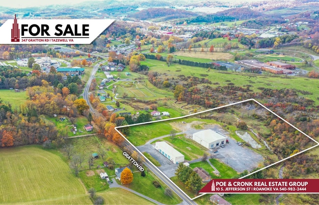
355 Gratton Rd
096 A 0016
EAST OF TAZEWELL 0.95 ACRE
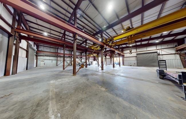
Officebuilding
TAZEWELL
AE The base floodplain where base flood elevations are provided. AE Zones are now used on new format FIRMs instead of A1-A30 Zones.
Virginia
2025
4.95 AC
2025
Virginia Regional
021101
Other Market Areas
7,834 SF
Bluefield, WV-VA
NEARBY LISTINGS FOR SALE OR LEASE
DEMOGRAPHICS near 355 Gratton Rd
1 mile
3 mile
5 mile
2025 Total Population
1,254
4,896
8,171
2030 Population
1,227
4,830
8,087
Pop Growth 2025-2030
(2.15%)
(1.35%)
(1.03%)
Average Age
45
45
45
2025 Total Households
522
2,047
3,421
HH Growth 2025-2030
(2.11%)
(1.32%)
(1.02%)
Median Household Inc
$38,951
$37,952
$44,678
Avg Household Size
2.20
2.20
2.20
2025 Avg HH Vehicles
2.00
2.00
2.00
Median Home Value
$143,558
$134,666
$128,107
Median Year Built
1970
1971
1973
Nearby Places
Map Layers
Map Styles
 Street
 Aerial
Layers
 Traffic
 Biking
Places
Listings with unknown addresses are not visible on the map
- Restaurants
- Banks
- Shops
- Fitness
- Groceries
SALE & LEASE HISTORY
LISTING DATE
SALE/LEASE

Dec 03, 2024
For Sale
Nearby Properties
Address
Land Use
TOTAL SIZE
Lot Size
Zoning
Address
Land Use
TOTAL SIZE
Lot Size
Zoning
142,384 SF
1.83 AC
Address
Land Use
TOTAL SIZE
Lot Size
Zoning
2,208 SF
48 AC
Address
Land Use
TOTAL SIZE
Lot Size
Zoning
12.22 AC
Address
Land Use
TOTAL SIZE
Lot Size
Zoning
37,367 SF
2.51 AC
Address
Land Use
TOTAL SIZE
Lot Size
Zoning
8,580 SF
3.54 AC
Address
Land Use
TOTAL SIZE
Lot Size
Zoning
4.51 AC
Address
Land Use
TOTAL SIZE
Lot Size
Zoning
71,198 SF
6.17 AC
Address
Land Use
TOTAL SIZE
Lot Size
Zoning
4,028 SF
9.30 AC
Address
Land Use
TOTAL SIZE
Lot Size
Zoning
56,482 SF
12.89 AC
Address
Land Use
TOTAL SIZE
Lot Size
Zoning
32,607 SF
4.82 AC
Address
Land Use
TOTAL SIZE
Lot Size
Zoning
35,041 SF
8.84 AC
Address
Land Use
TOTAL SIZE
Lot Size
Zoning
20,716 SF
2.96 AC
Address
Land Use
TOTAL SIZE
Lot Size
Zoning
34,124 SF
2.79 AC
Address
Land Use
TOTAL SIZE
Lot Size
Zoning
3,984 SF
6.69 AC
Address
Land Use
TOTAL SIZE
Lot Size
Zoning
31,604 SF
5.32 AC
Address
Land Use
TOTAL SIZE
Lot Size
Zoning
38,760 SF
4.52 AC
Address
Land Use
TOTAL SIZE
Lot Size
Zoning
50,017 SF
20.16 AC
Address
Land Use
TOTAL SIZE
Lot Size
Zoning
6,600 SF
2.93 AC
Address
Land Use
TOTAL SIZE
Lot Size
Zoning
64,508 SF
4.07 AC
Address
Land Use
TOTAL SIZE
Lot Size
Zoning
1,536 SF
2.32 AC
Address
Land Use
TOTAL SIZE
Lot Size
Zoning
39,270 SF
8.04 AC
Address
Land Use
TOTAL SIZE
Lot Size
Zoning
Address
Land Use
TOTAL SIZE
Lot Size
Zoning
30,822 SF
0.91 AC
Address
Land Use
TOTAL SIZE
Lot Size
Zoning
96,200 SF
3.37 AC
Address
Land Use
TOTAL SIZE
Lot Size
Zoning
3,984 SF
3.12 AC
Address
Land Use
TOTAL SIZE
Lot Size
Zoning
6,048 SF
5.58 AC
Address
Land Use
TOTAL SIZE
Lot Size
Zoning
8,550 SF
1.80 AC
Address
Land Use
TOTAL SIZE
Lot Size
Zoning
2,472 SF
51.37 AC
Address
Land Use
TOTAL SIZE
Lot Size
Zoning
2,050 SF
1.31 AC
Address
Land Use
TOTAL SIZE
Lot Size
Zoning
16,623 SF
2.97 AC
The World's #1 Commercial Real Estate Marketplace
Connect with us
© 2026 CoStar Group
The information above has been obtained from sources believed reliable. While we do not doubt its accuracy we have not verified it and make no guarantee, warranty or representation about it. It is your responsibility to independently confirm its accuracy and completeness. Any projections, opinions, assumptions, or estimates used are for example only and do not represent the current or future performance of the property. The value of this transaction to you depends on tax and other factors which should be evaluated by your tax, financial, and legal advisors. You and your advisors should conduct a careful, independent investigation of the property to determine to your satisfaction the suitability of the property for your needs.