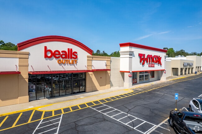
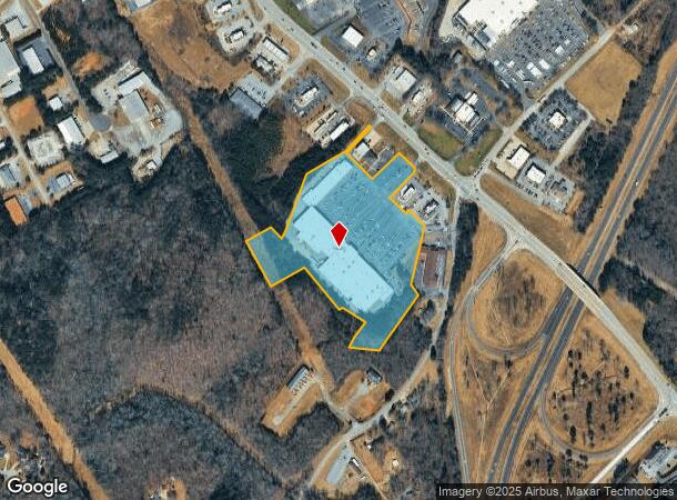
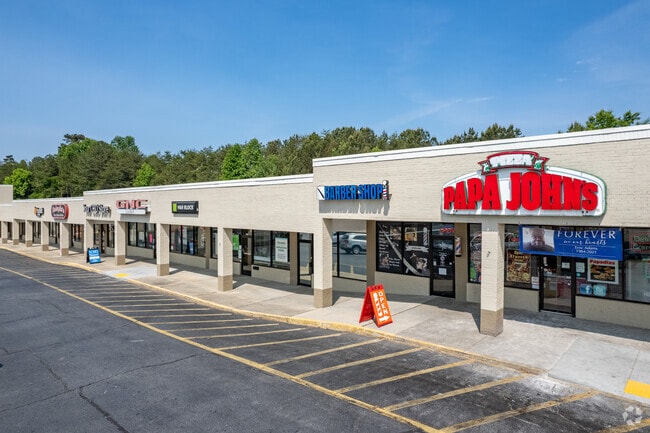
Property Record
355 Hist Hwy, Cornelia, GA 30531
NEARBY LISTINGS FOR SALE OR LEASE
Property Detail
355 Hist Hwy
083-015
New Plan Realty Trust
Wholesaleoutletdiscountstore
K-MART #9657 DB 1188-503
X
Habersham
13137C0216D
Georgia
2025
15.25 AC
2025
Georgia Northeast
000604
Other Market Areas
131,703 SF
Cornelia, GA
DEMOGRAPHICS near 355 Hist Hwy
1 Mile
3 Mile
5 Mile
2024 Total Population
1,280
15,554
27,778
2029 Population
1,406
17,103
30,569
Pop Growth 2024-2029
+ 9.84%
+ 9.96%
+ 10.05%
Average Age
37
38
39
2024 Total Households
446
5,480
9,935
HH Growth 2024-2029
+ 10.09%
+ 9.78%
+ 9.79%
Median Household Inc
$67,916
$52,172
$56,257
Avg Household Size
2.40
2.70
2.70
2024 Avg HH Vehicles
2.00
2.00
2.00
Median Home Value
$190,115
$162,158
$169,984
Median Year Built
1992
1986
1989
Nearby Places
Map Layers
Map Styles
 Street
 Aerial
- Restaurants
- Banks
- Shops
- Fitness
- Groceries
SALE & LEASE HISTORY
LISTING DATE
SALE/LEASE

Sep 25, 2016
For Lease
May 26, 2017
For Lease
Mar 09, 2017
For Lease
Feb 14, 2018
For Lease
Dec 29, 2025
For Sale
Dec 20, 2018
For Sale
Nearby Properties
Address
Land Use
TOTAL SIZE
Lot Size
Zoning
Address
Land Use
TOTAL SIZE
Lot Size
Zoning
200,600 SF
46.46 AC
LI
Address
Land Use
TOTAL SIZE
Lot Size
Zoning
216,507 SF
159.83 AC
MI
Address
Land Use
TOTAL SIZE
Lot Size
Zoning
253,404 SF
22 AC
HI
Address
Land Use
TOTAL SIZE
Lot Size
Zoning
97,985 SF
30 AC
LI
Address
Land Use
TOTAL SIZE
Lot Size
Zoning
97,144 SF
18 AC
R1A
Address
Land Use
TOTAL SIZE
Lot Size
Zoning
88,728 SF
37.73 AC
LI
Address
Land Use
TOTAL SIZE
Lot Size
Zoning
195,516 SF
19.95 AC
B2
Address
Land Use
TOTAL SIZE
Lot Size
Zoning
153,996 SF
24.72 AC
HI
Address
Land Use
TOTAL SIZE
Lot Size
Zoning
75,612 SF
29.13 AC
LI
Address
Land Use
TOTAL SIZE
Lot Size
Zoning
266,882 SF
152.11 AC
I
Address
Land Use
TOTAL SIZE
Lot Size
Zoning
119,632 SF
7.49 AC
HB
Address
Land Use
TOTAL SIZE
Lot Size
Zoning
57,800 SF
2.58 AC
SFR
Address
Land Use
TOTAL SIZE
Lot Size
Zoning
77,729 SF
69.23 AC
I
Address
Land Use
TOTAL SIZE
Lot Size
Zoning
55,608 SF
27.85 AC
I
Address
Land Use
TOTAL SIZE
Lot Size
Zoning
137,005 SF
20.74 AC
HI
Address
Land Use
TOTAL SIZE
Lot Size
Zoning
119,181 SF
12.98 AC
HI
Address
Land Use
TOTAL SIZE
Lot Size
Zoning
210,142 SF
27.50 AC
HI
Address
Land Use
TOTAL SIZE
Lot Size
Zoning
161,855 SF
26.12 AC
HI
Address
Land Use
TOTAL SIZE
Lot Size
Zoning
175,337 SF
10.63 AC
I
Address
Land Use
TOTAL SIZE
Lot Size
Zoning
75,762 SF
9.98 AC
R2
Address
Land Use
TOTAL SIZE
Lot Size
Zoning
27,492 SF
25.58 AC
LI
Address
Land Use
TOTAL SIZE
Lot Size
Zoning
53,453 SF
27.79 AC
R1
Address
Land Use
TOTAL SIZE
Lot Size
Zoning
21,168 SF
5.32 AC
HI
Address
Land Use
TOTAL SIZE
Lot Size
Zoning
35,874 SF
4 AC
HI
Address
Land Use
TOTAL SIZE
Lot Size
Zoning
4,296 SF
5 AC
R111
Address
Land Use
TOTAL SIZE
Lot Size
Zoning
76,344 SF
38.40 AC
HI
Address
Land Use
TOTAL SIZE
Lot Size
Zoning
47,520 SF
2.02 AC
HI
Address
Land Use
TOTAL SIZE
Lot Size
Zoning
137,296 SF
23.65 AC
I
Address
Land Use
TOTAL SIZE
Lot Size
Zoning
30,632 SF
16.42 AC
LI
The World's #1 Commercial Real Estate Marketplace
Connect with us
© 2025 CoStar Group
The information above has been obtained from sources believed reliable. While we do not doubt its accuracy we have not verified it and make no guarantee, warranty or representation about it. It is your responsibility to independently confirm its accuracy and completeness. Any projections, opinions, assumptions, or estimates used are for example only and do not represent the current or future performance of the property. The value of this transaction to you depends on tax and other factors which should be evaluated by your tax, financial, and legal advisors. You and your advisors should conduct a careful, independent investigation of the property to determine to your satisfaction the suitability of the property for your needs.