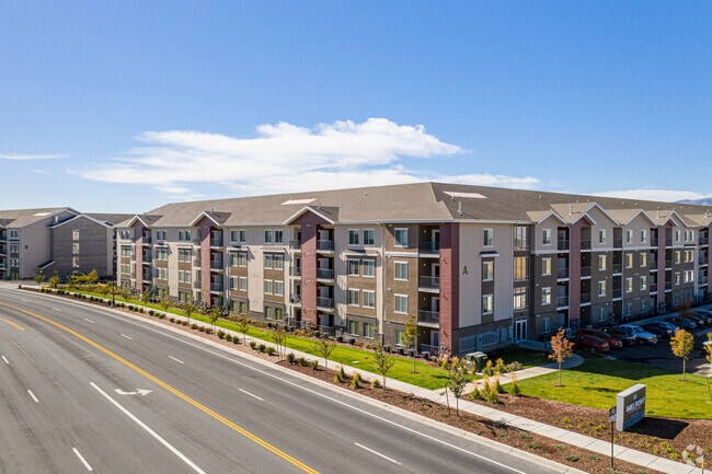
Property Record
355 N Mill Rd, Vineyard, UT 84059

Property Detail
355 N Mill Rd
Provo-Orem-Lehi, UT
PART LOT 1, GENEVA PARK EAST, PHASE TWO SUB DESCRIBED AS FOLLOWS; COM S 0 DEG 3 6 E 52.83 FT & W 1451.14 FT FR NE COR. SEC. 17, T6S, R2E, SLB&M.; S 0 DEG 33 46 E .78 FT; N 89 DEG 26 6 E 12.01 FT; ALONG A CURVE TO R (CHORD BEARS: S 45 DEG 33 52 E 21.2
40-470-0004
Utah
Multifamilydwelling
Utah
2024
1
2025
15.90 AC
002209
Outer Orem
472,365 SF
Salt Lake City
NEARBY LISTINGS FOR SALE OR LEASE
DEMOGRAPHICS near 355 N Mill Rd
1 mile
3 mile
5 mile
2025 Total Population
15,850
91,728
192,738
2030 Population
17,982
100,865
210,936
Pop Growth 2025-2030
+ 13.45%
+ 9.96%
+ 9.44%
Average Age
27
32
33
2025 Total Households
5,014
28,244
59,227
HH Growth 2025-2030
+ 14.18%
+ 10.72%
+ 10.22%
Median Household Inc
$103,107
$89,877
$92,574
Avg Household Size
3.20
3.10
3.20
2025 Avg HH Vehicles
2.00
2.00
2.00
Median Home Value
$640,954
$520,025
$552,602
Median Year Built
2011
1996
1995
Nearby Places
Map Layers
Map Styles
 Street
 Aerial
Layers
 Traffic
 Biking
Places
Listings with unknown addresses are not visible on the map
- Restaurants
- Banks
- Shops
- Fitness
- Groceries
PUBLIC TRANSPORTATION
COMMUTER RAIL
Vineyard Station (FrontRunner - Utah Transit Authority (UTA))
Drive
Walk
Distance
Vineyard Station (FrontRunner - Utah Transit Authority (UTA))
2 min
1.1 mi
Orem Central Station (FrontRunner - Utah Transit Authority (UTA))
Drive
Walk
Distance
Orem Central Station (FrontRunner - Utah Transit Authority (UTA))
5 min
2.2 mi
AIRPORT
Provo Municipal
Drive
Walk
Distance
Provo Municipal
15 min
9.1 mi
Freight Ports
Port of Stockton
Drive
Walk
Distance
Port of Stockton
751 min
733.3 mi
Nearby Properties
Address
Land Use
TOTAL SIZE
Lot Size
Zoning
Address
Land Use
TOTAL SIZE
Lot Size
Zoning
206,178 SF
16.64 AC
Address
Land Use
TOTAL SIZE
Lot Size
Zoning
1,003,185 SF
9.57 AC
Address
Land Use
TOTAL SIZE
Lot Size
Zoning
736,672 SF
7.04 AC
Address
Land Use
TOTAL SIZE
Lot Size
Zoning
349,971 SF
11.43 AC
Address
Land Use
TOTAL SIZE
Lot Size
Zoning
326,355 SF
15.12 AC
Address
Land Use
TOTAL SIZE
Lot Size
Zoning
233,302 SF
15.03 AC
Address
Land Use
TOTAL SIZE
Lot Size
Zoning
333,719 SF
11.99 AC
Address
Land Use
TOTAL SIZE
Lot Size
Zoning
430,273 SF
15.74 AC
Address
Land Use
TOTAL SIZE
Lot Size
Zoning
222,803 SF
18.48 AC
Address
Land Use
TOTAL SIZE
Lot Size
Zoning
268,060 SF
11.73 AC
Address
Land Use
TOTAL SIZE
Lot Size
Zoning
364,248 SF
22.77 AC
Address
Land Use
TOTAL SIZE
Lot Size
Zoning
139,462 SF
3.93 AC
Address
Land Use
TOTAL SIZE
Lot Size
Zoning
266,887 SF
8.12 AC
Address
Land Use
TOTAL SIZE
Lot Size
Zoning
194,483 SF
10.66 AC
Address
Land Use
TOTAL SIZE
Lot Size
Zoning
179,347 SF
13.55 AC
Address
Land Use
TOTAL SIZE
Lot Size
Zoning
72,761 SF
5.92 AC
Address
Land Use
TOTAL SIZE
Lot Size
Zoning
128,992 SF
12.39 AC
Address
Land Use
TOTAL SIZE
Lot Size
Zoning
204,655 SF
8.10 AC
Address
Land Use
TOTAL SIZE
Lot Size
Zoning
59,218 SF
6.88 AC
Address
Land Use
TOTAL SIZE
Lot Size
Zoning
17,165 SF
5.29 AC
Address
Land Use
TOTAL SIZE
Lot Size
Zoning
154,973 SF
5.18 AC
Address
Land Use
TOTAL SIZE
Lot Size
Zoning
135,893 SF
9.93 AC
Address
Land Use
TOTAL SIZE
Lot Size
Zoning
111,474 SF
8.98 AC
Address
Land Use
TOTAL SIZE
Lot Size
Zoning
2.76 AC
Address
Land Use
TOTAL SIZE
Lot Size
Zoning
123,663 SF
5.31 AC
Address
Land Use
TOTAL SIZE
Lot Size
Zoning
210,824 SF
3.42 AC
Address
Land Use
TOTAL SIZE
Lot Size
Zoning
133,455 SF
9.61 AC
Address
Land Use
TOTAL SIZE
Lot Size
Zoning
151,182 SF
6.41 AC
Address
Land Use
TOTAL SIZE
Lot Size
Zoning
127,495 SF
7.01 AC
The World's #1 Commercial Real Estate Marketplace
Connect with us
© 2026 CoStar Group
The information above has been obtained from sources believed reliable. While we do not doubt its accuracy we have not verified it and make no guarantee, warranty or representation about it. It is your responsibility to independently confirm its accuracy and completeness. Any projections, opinions, assumptions, or estimates used are for example only and do not represent the current or future performance of the property. The value of this transaction to you depends on tax and other factors which should be evaluated by your tax, financial, and legal advisors. You and your advisors should conduct a careful, independent investigation of the property to determine to your satisfaction the suitability of the property for your needs.