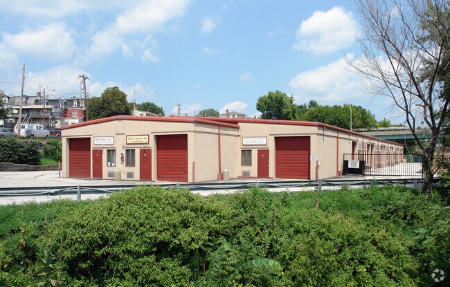
Property Record
355 W Main St, Norristown, PA 19401


NEARBY LISTINGS FOR SALE OR LEASE
Property Detail
355 W Main St
13-00-22976-006
93 X IRR 2.43 AC
Shipyard
Montgomery
AE
Pennsylvania
42029C0120G
2
2024
2.43 AC
2025
East Montgomery Cty
203803
Philadelphia
21,600 SF
Philadelphia-Camden-Wilmington, PA-NJ-DE-MD
DEMOGRAPHICS near 355 W Main St
1 Mile
3 Mile
5 Mile
2024 Total Population
29,319
98,331
195,190
2029 Population
29,787
100,152
199,182
Pop Growth 2024-2029
+ 1.60%
+ 1.85%
+ 2.05%
Average Age
35
40
40
2024 Total Households
10,277
38,928
77,993
HH Growth 2024-2029
+ 1.63%
+ 1.91%
+ 2.18%
Median Household Inc
$50,071
$79,683
$98,050
Avg Household Size
2.70
2.40
2.40
2024 Avg HH Vehicles
1.00
2.00
2.00
Median Home Value
$159,293
$277,328
$368,833
Median Year Built
1949
1964
1970
Nearby Places
Map Layers
Map Styles
 Street
 Aerial
- Restaurants
- Banks
- Shops
- Fitness
- Groceries
PUBLIC TRANSPORTATION
COMMUTER RAIL
Main Street (Norristown) (R6 - Southeastern Pennsylvania Transportation Authority Regional Rail (SEPTA Regional Rail))
DRIVE
WALK
Distance
Main Street (Norristown) (R6 - Southeastern Pennsylvania Transportation Authority Regional Rail (SEPTA Regional Rail))
1 min
2 min
0.1 mi
Elm Street (Norristown) (R6 - Southeastern Pennsylvania Transportation Authority Regional Rail (SEPTA Regional Rail))
DRIVE
WALK
Distance
Elm Street (Norristown) (R6 - Southeastern Pennsylvania Transportation Authority Regional Rail (SEPTA Regional Rail))
1 min
11 min
0.5 mi
AIRPORT
Philadelphia International
DRIVE
WALK
Distance
Philadelphia International
44 min
27.3 mi
Trenton Mercer
DRIVE
WALK
Distance
Trenton Mercer
55 min
39.1 mi
Freight Ports
South Jersey Port
DRIVE
WALK
Distance
South Jersey Port
38 min
23.4 mi
SALE & LEASE HISTORY
LISTING DATE
SALE/LEASE

Nov 20, 2019
For Lease
Mar 18, 2021
For Lease
Mar 01, 2017
For Lease
Nearby Properties
Address
Land Use
TOTAL SIZE
Lot Size
Zoning
Address
Land Use
TOTAL SIZE
Lot Size
Zoning
1,807,465 SF
120.12 AC
R2
Address
Land Use
TOTAL SIZE
Lot Size
Zoning
365,348 SF
80.44 AC
IN
Address
Land Use
TOTAL SIZE
Lot Size
Zoning
679,715 SF
58.23 AC
R2
Address
Land Use
TOTAL SIZE
Lot Size
Zoning
1,724,092 SF
24 AC
SC
Address
Land Use
TOTAL SIZE
Lot Size
Zoning
388,042 SF
24.45 AC
SM
Address
Land Use
TOTAL SIZE
Lot Size
Zoning
454,933 SF
17.85 AC
SM
Address
Land Use
TOTAL SIZE
Lot Size
Zoning
872,232 SF
51.99 AC
G
Address
Land Use
TOTAL SIZE
Lot Size
Zoning
422,975 SF
92.05 AC
RA
Address
Land Use
TOTAL SIZE
Lot Size
Zoning
413,892 SF
21.94 AC
SM
Address
Land Use
TOTAL SIZE
Lot Size
Zoning
843,567 SF
50.79 AC
HI
Address
Land Use
TOTAL SIZE
Lot Size
Zoning
197,108 SF
2.08 AC
SC
Address
Land Use
TOTAL SIZE
Lot Size
Zoning
217,564 SF
12.64 AC
IN
Address
Land Use
TOTAL SIZE
Lot Size
Zoning
231,665 SF
26.34 AC
OSR
Address
Land Use
TOTAL SIZE
Lot Size
Zoning
804,184 SF
26.72 AC
HR
Address
Land Use
TOTAL SIZE
Lot Size
Zoning
381,496 SF
5.37 AC
EC
Address
Land Use
TOTAL SIZE
Lot Size
Zoning
370,404 SF
15.55 AC
SM1
Address
Land Use
TOTAL SIZE
Lot Size
Zoning
310,900 SF
55.48 AC
HI
Address
Land Use
TOTAL SIZE
Lot Size
Zoning
320,804 SF
30.85 AC
CR
Address
Land Use
TOTAL SIZE
Lot Size
Zoning
333,974 SF
18.56 AC
HR
Address
Land Use
TOTAL SIZE
Lot Size
Zoning
667,719 SF
23.73 AC
BP
Address
Land Use
TOTAL SIZE
Lot Size
Zoning
142,124 SF
14.50 AC
AR
Address
Land Use
TOTAL SIZE
Lot Size
Zoning
320,737 SF
0.98 AC
TC
Address
Land Use
TOTAL SIZE
Lot Size
Zoning
639,052 SF
45 AC
SM
Address
Land Use
TOTAL SIZE
Lot Size
Zoning
416,392 SF
26.56 AC
HR
Address
Land Use
TOTAL SIZE
Lot Size
Zoning
208,680 SF
4.54 AC
LCI
Address
Land Use
TOTAL SIZE
Lot Size
Zoning
298,856 SF
9.58 AC
HR
Address
Land Use
TOTAL SIZE
Lot Size
Zoning
118,981 SF
4.24 AC
SM1
Address
Land Use
TOTAL SIZE
Lot Size
Zoning
257,196 SF
14.87 AC
AR
Address
Land Use
TOTAL SIZE
Lot Size
Zoning
299,018 SF
9.42 AC
SC
Address
Land Use
TOTAL SIZE
Lot Size
Zoning
311,784 SF
21.82 AC
A
The World's #1 Commercial Real Estate Marketplace
Connect with us
© 2026 CoStar Group
The information above has been obtained from sources believed reliable. While we do not doubt its accuracy we have not verified it and make no guarantee, warranty or representation about it. It is your responsibility to independently confirm its accuracy and completeness. Any projections, opinions, assumptions, or estimates used are for example only and do not represent the current or future performance of the property. The value of this transaction to you depends on tax and other factors which should be evaluated by your tax, financial, and legal advisors. You and your advisors should conduct a careful, independent investigation of the property to determine to your satisfaction the suitability of the property for your needs.